Maidstone Mapping Party 2010
Where and when
Area
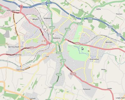
We made great progress during a mapping party over a year ago. Some areas are well mapped while others are completely blank, so check to see what areas need doing before heading out there.
If many people attend the event, we can move on to Leybourne and Snodland - there is no problem with lack of areas!
Meet, Location and Times
10am Saturday 27th March 2010, Plan A Location: Yumm Yumm's Deli Cafe, 2 Rose Lane, Maidstone Map. Their phone and website is disconnected. On the off chance they have closed permanently, I have designated a fall back location if the first venue is closed:
Plan B: Caffe Nero, House of Fraser, 44 Fremlin Walk ME14 1QP Map (Also note that there are two Caffe Neros in Maidstone!) If you don't want to risk walking to the wrong one, phone me on my mobile - I will try to be 15 min early to check the situation.
4pm Saturday 27th March 2010, Location: The Society Rooms (Wetherspoons), Brenchley House, Week Street, Maidstone, Kent, ME14 1RF Web Map
Sunset: 18:25 GMT (The clocks change that weekend, all times GMT)
If there are any changes of plan (i.e. you can't find us), phone Tim on 07719 775716.
What you need
- A GPS: recommended, but not essential. We will lend you one. Please add your name and note below, so we can ensure we will have sufficient receivers.
- You can use walking papers printouts if you don't have a GPS.
- Laptop/PDA: again recommended, but not essential. There are some mapping and tracking programs out there which can be used for generating GPX files and displaying maps.
- A camera: useful for mapping but also to have a nice souvenir
List of persons requesting receivers
Add names here as required.
Activities
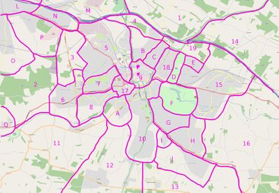
Add your name if you particularly want to do a particular area. I have prioritised the areas with the ones most needing work having letters and others that are more complete getting numbers. I have added the large park areas as priority areas as they probably have paths and other facilities that are not on the map. See also openstreetbugs.
| Area ID | Comments |
|---|---|
| A | Tovil |
| B | North Maidstone, Invicta Park Barracks(?), this area has significantly progressed since the cake diagram was produced. |
| C | North Maidstone, this area has significantly progressed since the cake diagram was produced. |
| D | Vinters Park |
| E | North-east Maidstone |
| F | Mote Park |
| G | North Shepway |
| H | South Shepway |
| I | Small area of south Maidstone |
| J | Parkwood |
| K | Leybourne, New Hythe |
| L | Larkfield |
| M | Aylesford |
| N | British Legion Village |
| O | East Malling |
| P | Ditton |
| Q | Teston |
| 1 | BlueBell Hill |
| 2 | Woods and countryside |
| 3 | Farmland, footpaths need work |
| 7 | Access roads to various schools missing. |
| 9 | Town centre |
| 17 | Several loose ends and missed roads. |
Who
If you are interested in attending to the mapping party, you can sign down here (this is an informal list, just to see who may be coming).
- TimSC 16:52, 1 February 2010 (UTC)
- Gregoryw 08:55, 2 February 2010 (UTC)
- TomS 23:24, 6 February 2010 (UTC) Will be staying in West Malling so happy to do Leybourne/ East Malling
- JennyH
Firefishy- Smsm1 unlikely to make it.
- Peter Childs Due to a mix of Family Problem and Sickness, I'm only going to make the 4pm Pub Meet.
- paulbiv More likely to take the train - cycling up the North Downs ridge after a day out is one of my less favourite journeys
- Joe osm newbie, doing a phd on collaborative mapping, hope you don't mind me tagging along!
Slices
| Gregoryw | H, then moving to G | Finished H, but possibly missed the occasional footpath, since there were lots of them. Only partial progress in G before I ran out of time. |
| TomS | P, O | Surveyed P and nearly finished O. Mapping in progress this week. |
Contact
Talk GB Mailing List or phone Tim +44 (0)7719 775716

