| aSmartHUD NAVI MAP+
|
|
|
| Author:
|
atoll-ordenadores.com
|
| License:
|
Proprietary (0.99$)
|
| Platform:
|
iPhone
|
| Version:
|
7.3 (2018-03-17)
|
| Language:
|
multiple languages
|
| Website:
|
http://atoll-ordenadores.com
|
| Install:
|
|
|
vehicle digital dashboard, unified with in-car navigation system
|
|
Features
| Feature
|
Value
|
| Map Display
|
| Display map
|
yes
|
| Map data
|
vector
|
| Source
|
offline
|
| Rotate map
|
yes
|
| 3D view
|
yes
|
| Shows website
|
?
|
| Shows phone number
|
?
|
| Shows operation hours
|
?
|
| Routing
|
| Routing
|
yes
|
| Create route manually
|
?
|
| Calculate route
|
?
|
| Create route via Waypoints
|
?
|
| Routing profiles
|
car
|
| Turn restrictions
|
?
|
| Calculate route without Internet (Offline routing)
|
?
|
| Routing providers
|
?
|
| Avoid traffic
|
?
|
| Traffic Provider
|
?
|
| Navigating
|
| Navigate
|
yes
|
| Find location
|
?
|
| Find nearby POIs
|
no
|
| Navigate to point
|
yes
|
| Navigation with voice / Voice guidance
|
no
|
| Keep on road
|
no
|
| Lane guidance
|
?
|
| Works without GPS
|
?
|
| Navigate along predefined route
|
?
|
| Tracking
|
| Make track
|
yes
|
| Customizable log interval
|
?
|
| Track formats
|
?
|
| Geotagging
|
?
|
| Fast POI buttons
|
?
|
| Upload GPX to OSM
|
?
|
| Monitoring
?
|
| Editing
?
|
| Rendering
?
|
| Accessibility
|
| Accessibility support
|
?
|
| Complete non graphics text output
|
no
|
| Braille interface
|
no
|
| Exploration modus
|
?
|
| Public Transport mode
|
no
|
| Danger Warnings
|
?
|
| Screenreader
|
?
|
| Screenreader languages
|
?
|
|
|
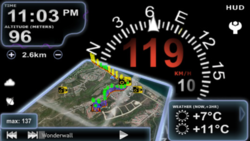
aSmartHUD NAVI MAP+ (http://atoll-ordenadores.com) is an iOS app claiming to be an "advanced and easy to use vehicle digital dashboard" it offers "OpenStreetMap with 6 different color schemes"
It has a database of speed cameras which is presumably NOT based on OpenStreetMap / open data, but does allow editing
