Amsterdam Underground
Overview
The Amsterdam Metro network consists of three heavy rail metro lines Oostlijn (53 & 54), Noord-Zuidlijn (52) and two light rail lines Ringlijn (50) and Amstelveenlijn (51). The inner city part, from Central Station to Amstel station is underground. Most of the tracks are (far) above ground level. In 2018 an addition to the underground rail network, the Noord-Zuidlijn (52), opened.
All lines share much of their track (bed) with NS or other GVB tracks. Those tracks should be and are mapped separately.
The Amsterdam Metro lines are operated by GVB.
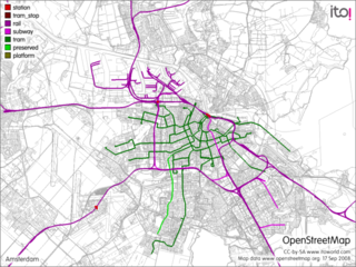
Here is a map of the Metro network.
All lines are standard gauge, power is provided through a third rail.
Lines
Oostlijn (53/54) CS - Zuidoost
The Oostlijn starts at Centraal Station, runs underground to Amstel station, runs above ground to Van der Madeweg, then branches out to Gaasperplas (53) and Gein (54) terminuses. From Amstel to Bullewijk, the track bed is shared with NS tracks.
Stations CS and Amstel are shared with NS train stations. On the Gaasperplas branch 53 also Diemen-Zuid. On the Gein branch 54: Duivendrecht and Bijlmer ArenA (and from 2009 on also Holendrecht).
Status
Stations are mapped. Tracks are mapped.
Relation of route 53 (Gaasperplas): https://www.openstreetmap.org/browse/relation/18532
Relation of route 54 (CS - Gein): https://www.openstreetmap.org/browse/relation/18423
Ringlijn (50) Gein - Isolatorweg
The Ringlijn runs from Gein via Holendrecht, Bijlmer, Duivendrecht, Zuid, Lelylaan, Sloterdijk to its terminus Isolatorweg in Westpoort. All of the track is above ground level. It shares most of its track (bed) with NS or other GVB tracks.
Stations Bijlmer ArenA, Duivendrecht, RAI, Zuid, Lelylaan, Sloterdijk are shared with NS train stations (and from 2009 on also Holendrecht).
Status
Stations are mapped. Tracks are mapped.
Relation of route: https://www.openstreetmap.org/browse/relation/18683
Line 51 CS - Isolatorweg
Line 51 shares its track with the Oostlijn from Central Station to Spaklerweg, then branches west to Zuid and from there one shares its track with the Ringlijn to Isolatorweg. From CS to Amstel underground, rest above ground. It shares most of its track (bed) with NS or other GVB tracks.
Stations CS, Amstel, RAI, Zuid are shared with NS train stations.
Status
Stations are mapped. Tracks are mapped.
Relation of route: https://www.openstreetmap.org/browse/relation/31249
Noord-Zuidlijn (52) Zuid - Noord
The Noord-Zuidlijn runs from Zuid via Roking, Amsterdam CS to its terminus Noord in Amsterdam Noord. From Europaplein to Noorderpark underground, rest above ground.
Stations Zuid, Amsterdam CS are shared with NS train stations.
Status
Stations are mapped. Tracks are mapped.
Relation of route: https://www.openstreetmap.org/relation/8466671
