File:Cincinnati Bike Maps 04.jpg
Jump to navigation
Jump to search


Size of this preview: 800 × 536 pixels. Other resolutions: 320 × 214 pixels | 640 × 428 pixels | 1,024 × 685 pixels | 1,280 × 857 pixels | 2,560 × 1,714 pixels | 3,872 × 2,592 pixels.
Original file (3,872 × 2,592 pixels, file size: 4.38 MB, MIME type: image/jpeg)
This file and its description are from Wikimedia Commons.
This is a Featured image, which means that it has been identified as one of the best examples of OpenStreetMap mapping, or that it provides a useful illustration of the OpenStreetMap project. If you know another image of similar quality, you can nominate it on Featured image proposals.
Front-page image for week 43 of 2014 (20–26 Oct.).
- Image descriptions
- Deutsch : Nate Wessel hat diesen Monat eine aus OpenStreetMap-Daten erzeugte, farbige Fahrradkarte von Cincinnati, Ohio veröffentlicht, von der 9.000 Stück vor Ort verteilt werden. Anders als andere Fahrradkarten, die sich auf eine Auswahl "bevorzugter" Fahrradwege konzentrieren, gibt die Cincinnati Bike Map den Zustand aller Straßen wider.
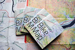
- English : This month, Nate Wessel published a full-color cycle map of Cincinnati, Ohio, United States, based on OpenStreetMap data. A print run of 9,000 is being distributed locally. Unlike many urban cycle maps, which highlight a curated selection of "preferred" routes for cyclists, the Cincinnati Bike Map indicates road conditions for all roads.
- français : Nate Wessel a publié une carte cyclable en couleur de Cincinnati, une ville de l'état de l'Ohio aux États-Unis, utilisant les données d'OpenStreetMap. Un ensemble de 9 000 impressions sont distribuées localement. Contrairement aux autres cartes qui surlignent les routes préférables pour les cyclistes, cette carte indique les conditions de toutes les routes.
- italiano : Questo mese, Nate Wessel ha pubblicato una mappa ciclistica a colori di Cincinnati, Ohio basata su dati di OpenStreetMap. La distribuzione di 9000 copie sta avvenendo localmente. Diversamente da altre mappe ciclistiche cittadine, che evidenziano una selezione curata di percorsi "preferiti" per ciclisti, la Cincinnati Bike Map indica le condizioni di tutte le strade.
- русский : В сентябре этого года участник Нейт Вессел напечатал 9 000 цветных карт для их последующей раздачи велосипедистам города Цинциннати (штат Огайо, США). В отличие от многих похожих листовок, где описаны лишь рекомендованные для велосипедистов участки улиц, на этой карте показано состояние всех местных дорог.
- 中文(繁體) : 這個月,Nate Wessel 使用放街圖圖資,出版美國俄亥俄辛辛那提一帶的全彩單車地圖,將會在全美國各地,總共發行 9,000 份地圖。這份地圖不像其他都市單車地圖,只挑選「偏好」的單車路徑,辛辛那提單車地圖顯示所有道路的道路狀況。
Summary
| Description |
English: The Cincinnati Bike Map, a comprehensive cycle map of Cincinnati, Ohio, based on OpenStreetMap data, shown folded and unfolded. |
| Date | |
| Source | Own work |
| Author | Nate Wessel |
Licensing
I, the copyright holder of this work, hereby publish it under the following license:
This file is licensed under the Creative Commons Attribution 4.0 International license.
- You are free:
- to share – to copy, distribute and transmit the work
- to remix – to adapt the work
- Under the following conditions:
- attribution – You must give appropriate credit, provide a link to the license, and indicate if changes were made. You may do so in any reasonable manner, but not in any way that suggests the licensor endorses you or your use.
| This work contains information from OpenStreetMap, which is made available under the Open Database License (ODbL).
The ODbL does not require any particular license for maps produced from ODbL data. Prior to 1 August 2020, map tiles produced by the OpenStreetMap Foundation were licensed under the CC-BY-SA-2.0 license. Maps produced by other people may be subject to other licences. |
File history
Click on a date/time to view the file as it appeared at that time.
| Date/Time | Thumbnail | Dimensions | User | Comment | |
|---|---|---|---|---|---|
| current | 16:26, 5 October 2014 | | 3,872 × 2,592 (4.38 MB) | wikimediacommons>Nate Wessel | User created page with UploadWizard |
File usage
The following 7 pages use this file: