File:Circuit des Chênes-Openstreetmap-Nantes.png
Jump to navigation
Jump to search


Size of this preview: 800 × 540 pixels. Other resolutions: 320 × 216 pixels | 640 × 432 pixels | 1,024 × 692 pixels | 1,280 × 865 pixels | 2,560 × 1,729 pixels | 3,963 × 2,677 pixels.
Original file (3,963 × 2,677 pixels, file size: 3.01 MB, MIME type: image/png)
Summary
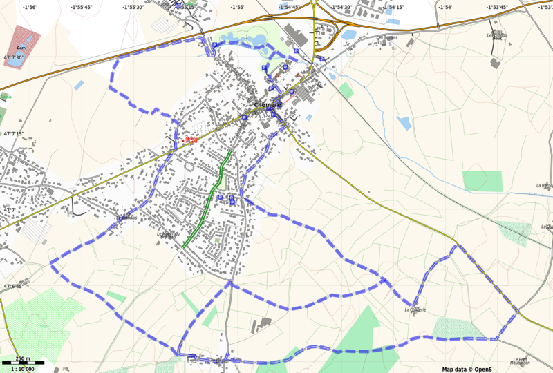
Carte de randonnée du Circuit des Chênes, commune de Chéméré. Cette carte a été produite avec le logiciel Maperitive avec la feuille de style R25 de JBacc1. Carte réalisée lors de l'Opération Libre du 25 au 27 septembre 2015.
Licensing
![]()
![]()
![]()
This work is licensed under the Creative Commons Attribution-ShareAlike 3.0 License.
Missing attribution. You have to add the authors!
THIS LICENSE REQUIRES ATTRIBUTION!
Use {{CC-BY-SA-3.0|Authors}}
Missing attribution. You have to add the authors!
THIS LICENSE REQUIRES ATTRIBUTION!
Use {{CC-BY-SA-3.0|Authors}}
File history
Click on a date/time to view the file as it appeared at that time.
| Date/Time | Thumbnail | Dimensions | User | Comment | |
|---|---|---|---|---|---|
| current | 20:11, 3 October 2015 | | 3,963 × 2,677 (3.01 MB) | Naomap (talk | contribs) | Carte de randonnée du Circuit des Chênes, commune de Chéméré. Cette carte a été produite avec le logiciel Maperitive avec la feuille de style R25 de JBacc1. Carte réalisée lors de l'Opération Libre du 25 au 27 septembre 2015. |
You cannot overwrite this file.
File usage
The following 2 pages use this file:
- Nantes/Evenements/Operation Libre Chéméré
- File:Circuit des Chênes.png (file redirect)