File:EnglandLondon.png
Jump to navigation
Jump to search
No higher resolution available.
EnglandLondon.png (200 × 247 pixels, file size: 12 KB, MIME type: image/png)
This file and its description are from Wikimedia Commons.
| Description |
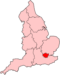
English: Locator map showing Greater London
Français : Carte situant le Grand Londres en Angleterre
Magyar: Nagy-London elhelyezkedését mutató térkép. |
|||
| Source | ||||
| Author | original from Morwen on en: | |||
| Other versions |
|


|
Permission is granted to copy, distribute and/or modify this document under the terms of the GNU Free Documentation License, Version 1.2 or any later version published by the Free Software Foundation; with no Invariant Sections, no Front-Cover Texts, and no Back-Cover Texts. A copy of the license is included in the section entitled GNU Free Documentation License. |
| This file is licensed under the Creative Commons Attribution-Share Alike 3.0 Unported license. | ||
| ||
| This licensing tag was added to this file as part of the GFDL licensing update. |
File history
Click on a date/time to view the file as it appeared at that time.
| Date/Time | Thumbnail | Dimensions | User | Comment | |
|---|---|---|---|---|---|
| current | 20:14, 22 February 2011 | | 200 × 247 (12 KB) | wikimediacommons>Mahahahaneapneap | Transparent background |
File usage
The following page uses this file: