File:Europäische Wasserscheiden.png

Original file (1,200 × 1,184 pixels, file size: 526 KB, MIME type: image/png)
Summary
| Description |
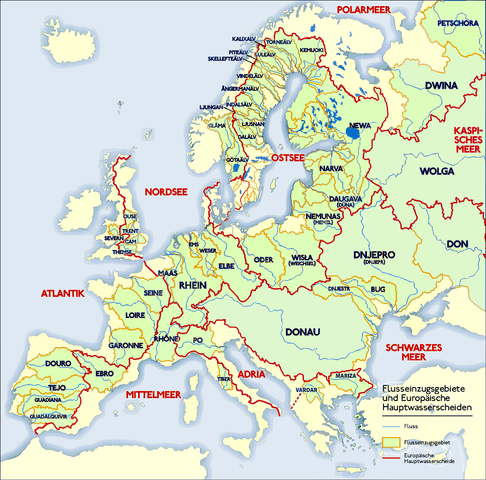
Deutsch: Grafik zeigt die Europäischen Flusseinzugsgebiete und Hauptwasserscheiden.
Zeichnung erstellt 06/2004 von Sansculotte. Bild ist unter der Creative Commons Share Alike zur weiteren Verwendung freigegeben. Quellenangabe und Beleg an sansculotte@despammed.com erbeten.English: The map shows the European rivers' catchment areas and main watersheds.
Chart made on 06/2004 by de:Sansculotte. The image is released under the Creative Commons Share Alike license for futher use. Reference and sources can be requested from sansculotte@despammed.comFrançais : Carte des bassins fluviaux d'Europe. Carte établie en juin 2004 par le contributeur de:Sansculotte
Sources (!) disponibles par demande à sansculotte@despammed.com
|
||||||||
| Date | |||||||||
| Source | Source: German Wikipedia, original upload see file history | ||||||||
| Author | Sansculotte | ||||||||
| Permission (Reusing this file) |
This file is licensed under the Creative Commons Attribution-Share Alike 2.0 Generic license.
|
||||||||
| Other versions |
Derivative works of this file:
|


|
File history German Wikipedia
(Löschen) (Aktuell) 16:54, 15. Jan 2005 . . Sansculotte . . 1200x1184 (602233 Byte) (korr.)
(Löschen) (Zurücksetzen) 05:01, 3. Jun 2004 . . Sansculotte . . 1000x987 (262710 Byte) (eigene Darstellung, GNU FDL, Europäische Flußeinzugsgebiete und Hauptwasserscheiden)
(Löschen) (Zurücksetzen) 04:21, 3. Jun 2004 . . Sansculotte . . 1000x987 (183238 Byte) (eigene Darstellung, GNU FDL, Europäische Flußeinzugsgebiete und Hauptwasserscheiden)
File history
Click on a date/time to view the file as it appeared at that time.
| Date/Time | Thumbnail | Dimensions | User | Comment | |
|---|---|---|---|---|---|
| current | 08:45, 31 July 2019 | | 1,200 × 1,184 (526 KB) | wikimediacommons>1970gemini | entschleiert |
File usage
There are no pages that use this file.