File:FIväistääPaitsitonttiepäselvyys.png
Jump to navigation
Jump to search

No higher resolution available.
FIväistääPaitsitonttiepäselvyys.png (350 × 234 pixels, file size: 57 KB, MIME type: image/png)
Summary
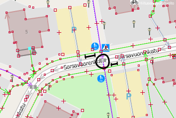
A intersection in Finland between a cycleway and a road, with parking space connections really close. It is unclear, when a driver joining onto the road is no longer "coming from a parking area or similar" but plain "on the road", i.e. at what distance the cyclists crossing the road must then give way to him or her, and not the other way round. Distances marked here are 7 to 9 meters, from cyclist's crossing edge to service way edge.
(OSM data in JOSM with OSM "standard" layer tiles in the background)
Licensing
![]()
![]()
![]()
This work is licensed under the Creative Commons Attribution-ShareAlike 2.0 License.
Missing attribution. You have to add the authors!
THIS LICENSE REQUIRES ATTRIBUTION!
Use {{CC-BY-SA-2.0|Authors}}
Note, there is
There is also
Missing attribution. You have to add the authors!
THIS LICENSE REQUIRES ATTRIBUTION!
Use {{CC-BY-SA-2.0|Authors}}
Note, there is
{{CC-BY-SA-2.0 OpenStreetMap}} for files based on old OSM map data, before the license change made on 2012-09-12.There is also
{{OSM Carto screenshot||old_license}} for files based on old OSM map data, before the license change made on 2012-09-12, created using OSM Carto map style.
File history
Click on a date/time to view the file as it appeared at that time.
| Date/Time | Thumbnail | Dimensions | User | Comment | |
|---|---|---|---|---|---|
| current | 17:45, 22 August 2013 | | 350 × 234 (57 KB) | Alv (talk | contribs) | A intersection in Finland between a cycleway and a road, with parking space connections really close. It is unclear, when a driver joining onto the road is no longer "coming from a parking area or similar" but plain "on the road", i.e. at what distance... |
You cannot overwrite this file.
File usage
The following page uses this file: