File:FIväistääTämäosa.png
Jump to navigation
Jump to search

No higher resolution available.
FIväistääTämäosa.png (350 × 310 pixels, file size: 61 KB, MIME type: image/png)
Summary
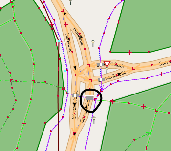
A intersection of two roads in Finland, with a cycleway crossing each road. Here, cyclists must always give way to the drivers on the secondary road on the part circled in this picture. On the western part of that crossing, after the center island, turning vehicles give way to the same cyclists.
(OSM data in JOSM with OSM "standard" layer tiles in the background)
Licensing
![]()
![]()
![]()
This work is licensed under the Creative Commons Attribution-ShareAlike 2.0 License.
Missing attribution. You have to add the authors!
THIS LICENSE REQUIRES ATTRIBUTION!
Use {{CC-BY-SA-2.0|Authors}}
Note, there is
There is also
Missing attribution. You have to add the authors!
THIS LICENSE REQUIRES ATTRIBUTION!
Use {{CC-BY-SA-2.0|Authors}}
Note, there is
{{CC-BY-SA-2.0 OpenStreetMap}} for files based on old OSM map data, before the license change made on 2012-09-12.There is also
{{OSM Carto screenshot||old_license}} for files based on old OSM map data, before the license change made on 2012-09-12, created using OSM Carto map style.
File history
Click on a date/time to view the file as it appeared at that time.
| Date/Time | Thumbnail | Dimensions | User | Comment | |
|---|---|---|---|---|---|
| current | 16:38, 22 August 2013 | | 350 × 310 (61 KB) | Alv (talk | contribs) | A intersection of two roads in Finland, with a cycleway crossing each road. Here, cyclists must always give way to the drivers on the secondary road on the part circled in this picture. On the western part of that crossing, after the center island, tur... |
You cannot overwrite this file.
File usage
The following page uses this file: