United Kingdom Neighbourhood Planning Project

The United Kingdom Neighbourhood Planning Project tested the potential for using OpenStreetMap to store and share information about Neighbourhood Plans in England. (See gov.uk information about Neighbourhood Planning)
User:Semantictourist kicked off this initiative in 2013
Focus
The initial focus was on two aspects:
1. experimenting with different methods to capture and digitise Neighbourhood Plan boundaries
2. experimenting with OSM tags as a means to uniquely identify and re-use Neighbourhood Plan data.
If it works, the hope is that the project will:
1. encourage and involve local communities, e.g. to contribute mapping about planning and the environment in their local area; and
2. enable interactive tools to be built using an OSM-based map
Sources
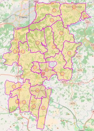
A test dataset was based on 18 designated Neighbourhood Plan areas in mid-sussex.
User:Semantictourist worked his way through these areas, capturing and digitising neighbourhood plan boundaries, as published by Mid Sussex District Council [1].
The boundaries for individual Neigbourhood Plan areas are defined in various ways. The three main variations in the test dataset are:
- areas based on a full Civil Parish boundary. For these, I have re-used the polygon defined by Ordnance Survey, in its latest (May 2012) Boundary-Line product.
- areas based on partial Civil Parish boundaries. For these, I have again used OS's polygon, then edited it to fit the boundary described in the papers published by Mid Sussex District
- areas based on other boundaries - e.g. town councils - to be digitised based on boundaries published by Mid Sussex.
OSM tags
I have used the following OSM tag combination to uniquely identify each Neighbourhood Plan area:
These reflect the fact that Neighbourhood Plan areas are an official layer in the administrative geography (boundary=administrative), but different to other designated areas (hence designation=neighbourhood_plan). They are also typically set at a level equivalent to Parish councils (hence admin_level=10).
I have included additional tags to provide further information about each area where this is available. Individual areas can contain one or more tags from the following list:
- idnparea
- name
- neighbourhood
- sourcemapurl
- local_authority_name
- local_authority_code
- qualifying_area
- area_type
- neighbourhood_plan_stage
- legend
- date_application
- date_designation
- area_site_url
- local_authority_url