Warwick, Rhode Island, USA Case Study
This case study examines two very similar parks in the city of Warwick, Rhode Island, USA Warwick, Rhode Island, USA. It is intended to demonstrate the existence of this class of park as well as show that there is often no distinction between state and city parks:
Map Comparison
Warwick City Park: 11739119 11739119 11739119
|
Tagging notes
|
|
|
- The boundary
 boundary of Warwick City Park is tagged with leisure=park. There are also overlapping regions of natural=wood that reflect natural wooded areas. This is incorrect, because the most of the park is tagged with leisure=park and natural=wood in order to indicate wild, natural wooded areas within the park boundary. However, this tag combination implies "manicured, wooded areas", which is not what is present. In this case, the renderer has "guessed right" in rendering the natural=wood, but there is no way to know from this rendering whether those areas are inside or outside the park. boundary of Warwick City Park is tagged with leisure=park. There are also overlapping regions of natural=wood that reflect natural wooded areas. This is incorrect, because the most of the park is tagged with leisure=park and natural=wood in order to indicate wild, natural wooded areas within the park boundary. However, this tag combination implies "manicured, wooded areas", which is not what is present. In this case, the renderer has "guessed right" in rendering the natural=wood, but there is no way to know from this rendering whether those areas are inside or outside the park.
- Internal regions not otherwise tagged default to the rendering of leisure=park, correctly indicating manicured park land.
- While the park name label does render, the park boundary is not visible because of the overlapping natural=wood areas. It is impossible to tell whether the park extends into the Buttonwoods neighborhood to the south, or into the wetland areas to the north and northwest.
|
Goddard State Park: 11582427 11582427 11582427
|
Tagging notes
|
|
|
- The boundary
 boundary of Goddard State Park is tagged with boundary=protected_area and protect_class=5. This tag combination causes the boundary to render, however, this park is not a conservation area. This is an example of tagging for the renderer. However, there is no semantically-correct way to tag a park border that renders. boundary of Goddard State Park is tagged with boundary=protected_area and protect_class=5. This tag combination causes the boundary to render, however, this park is not a conservation area. This is an example of tagging for the renderer. However, there is no semantically-correct way to tag a park border that renders.
- There are overlapping regions of natural=wood that reflect natural wooded areas.
- Internal regions of manicured park land are explicitly tagged with leisure=park.
- Both the park boundary and internal regions are visible.
- Internal features are tagged as applicable, e.g. the large public leisure=golf_course area. In this example, there is also a private golf course adjacent to and east of park. Without the rendering of the boundary, it would be impossible to determine that one golf course is inside the park and the other is outside the park.
|
Warwick City Park Photo Gallery
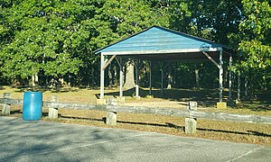
These photos of Warwick City Park demonstrate the mixed-use character of this park. Note that the photos are geotagged, and contain the exact location in the park where the photos were taken.
Gazebo and historical Marker
Wild, natural wooded areas
WDog park within the park
Oakland, California, USA Case Study
![]() Warwick, Rhode Island, USA. It is intended to demonstrate the existence of this class of park as well as show that there is often no distinction between state and city parks:
Warwick, Rhode Island, USA. It is intended to demonstrate the existence of this class of park as well as show that there is often no distinction between state and city parks:
 Warwick City Park, a local, partially-wooded mixed-use park.
 Goddard State Park, a partially-wooded mixed-use state park


