Pt:Bing Maps
Bing is a search service from Microsoft, which includes other wings of operation including the Bing Maps platform. This is the primary map offering from Microsoft. It was previously known as Microsoft Virtual Earth. It includes maps, map embedding APIs, routing etc. This is all powered from their proprietary datasets licensed from various geodata providers, much like google maps, yahoo maps, mapquest.com (the main map portal), and pretty much every other map provider out there. The maps you think of as "free" are all heavily restricted by expensive licenses... however
Bing Maps are investigating working with OpenStreetMap in various ways:
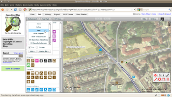
Imagens aéreas do Bing no editores do OpenStreetMap


O Bing Maps autorizou a utilização das suas imagens de satélite nos editores do OpenStreetMap, permitiu também traçar sobre essas imagens a fim de criar os mapas vetoriais.
color="red">new) 'Microsoft imagery details' on opengeodata.org, and 'Bing engages open maps community'
There are various other alternatives for Vertical Aerial Photographs. For several years Yahoo! have very generously allowed us to use their imagery, but bing's imagery eclipses this in resolution and coverage in many parts of the world.
Veja em Bing/Coverage a cobertura das imagens do Bing.
Usando as imagens do Bing
No Potlatch 2
Selecione 'Bing' no campo 'background' (no canto superior esquerdo)
No JOSM
Você vai precisar:
- Atualize seu JOSM para a última versão (Latest)
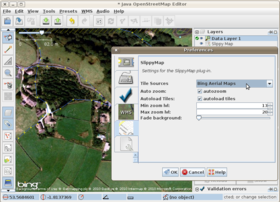
- Vá em Editar > Preferências > Aba Plugins e instale o plugin 'slippy map' (Existe também o plugin 'Imagery' que funciona melhor mas ainda não tem documentação.)
- Reinicie o JOSM
- Vá em Editar > Preferências > Aba Slippy Map (nova) e selecione 'Bing Aerial Maps'. Você deve também setar o 'max zoom lvl' em 20.
Em outros editores
Support in other editors is possible, and development is underway
Precisão
Be aware that at lower zooms, Bing's imagery may be misaligned. This is true of various places in the southwest US and Europe (if you see more areas, please add them here). Areas with height differences (mountains, hills, bridges) seem more prone to this, which suggests that imagery was not always taken at a precise 90 degree angle. As a result, objects at the same height (ground level in a flat area) may be quite precise while objects which are higher (embankments, bridges, buildings) or lower (cuttings) may be slightly off. Use GPS tracks to calibrate the aerial images.
Age of the aerial pictures
At this webservice you are supposed to see when the Bing material has been recorded: https://mvexel.dev.openstreetmap.org/bing/ Zoom in and out to see even different ages of each zoom levels! See discussion.
Source tag
Use source=Bing. (Essa é uma política do OSM, e não uma exigência do Bing.)
Licensa
Veja  . This was valid on 3rd December 2010 and may be superseded by later issues of the licence issued by Microsoft.
Background Information
Robert Scoble has a blog post on his visit to Bing's imaging center. It is not technical in nature, nor does it really provide any particularly reusable information—but is still a nice read.
OpenStreetMap on the Bing Maps platform
They have added an OpenStreetMap layer to their platform. This can be viewed on http://www.bing.com/maps/explore/#5003/s=w/5872/style=Mapnik&pid=50735 (requires Microsoft Silverlight 3—Moonlight 2 (latest stable release as of Dec 2010) will not work) and is available in the "map apps" area.
See also "Microsoft launch an OpenStreetMap Mapnik layer on Bing Maps" Announced Aug 2nd 2010