Sunderland Mapping Party 2009
Introduction
Sunderland was on the 2009 UK Mapping Priorities list, so we had a mapping party over the weekend of 2nd/3rd May 2009 to get some of it mapped! Nearby Durham was mapped quite well already, as was Newcastle so it was time to put Sunderland and its surroundings on the map.
- Aim - To map as much as we can, and naturally have fun in the process.
- Who - Open to all, experienced OSM'ers and new participants alike. Bring the family and children for a great day out.
- How - Bring along some transport (feet, bike, horse, car, rollerblades etc) and if you have one a GPS receiver, and also if you have one a digital camera or Dictaphone. There will be a number of nice GPS receivers with OSM mapping available to loan over the weekend if you need one though.
- Effort - The event will be over a weekend, you can come for just one day if you wish, or even just a few hours.
- More? - See below for more details
Results
When
Saturday 2nd - Sunday 3rd May 10am to 5pm each day (then to the pub!)
Come for a morning, afternoon, day or both days.
Who's Going/Went?
- LastGrape/Gregory both days
- Blackadder is organising and will be there all weekend
- Chippy is interested in attending.
- Sward is attending both days.
- Digital_elysium can't make it (new baby eats up any spare moment I have), but as a resident of Sunderland, would be happy to provide advice.
- Graham Jones will be there work permitting, but I'll need to do a southern bit of the city.
- Sphericalsquare will be attending for most of Saturday and possibly Sunday afternoon.
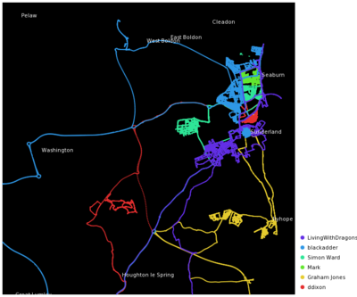
- Ddixon came on Sunday, and mapped bits of areas 5, 7 & 12.
Where
Marriott Hotel on the seafront in Seaburn. Marriott Hotel, Queens Parade, Sunderland, SR6 8DB Phone: 44 191 5292041. Map (ish) About 2 miles as the crow flies from the city centre.
Schedule
- 10am Meet up, learn how to collect the data, pick a section each to map
- 10:30 / 11am Go out and map your section
- 1:00pm Gather back to eat/chat/rest together for those that wish (carrying on mapping or having lunch on your own is fine)
- 2:00pm Out again to finish tackling your section, or another if you did well.
- 4:00pm Gather back again, see how much everyone did. An explanation will then be given on how to add to OSM all the data you collected. This is usually really important/helpful for beginners to set you on the road to map on your own. We should be able to let you try hands on adding the data you collected.
- 5:00pm Either going home or first going to a pub for a bit(unless we find a beer festival somewhere).
The two days will follow roughly the same pattern, although Sunday might involve less explaining (except for/if new people turning up) so you can pick your section and go.
Travel
Train (and metro)
Sunderland is on the "Durham Coast Line", and connects to Newcastle Central (on the East Coast Mainline, frequent/fast trains between Edingburgh and The South). From Newcastle it takes about 20-30 minutes, about 5 trains per hour.
Bicycles are allowed on Northern Rail services only from Newcastle(30 minutes past the hour) heading to Middlesborough. At the end of the tram-like train the 2-seat bench lifts up, providing just about enough space. Watch out for the door opening! Most services are the Tyne & Wear Metro, folding bicycles only (some types have to be in bags).
Car
- From The South: The A1 is a motorway by the time it gets near Durham, junction 61 is where you can come of onto the A690 to go into Sunderland.
- From The North: The A1 is just a primary road, at the junction where it turns into a motoway, come off instead and you can follow the A1231 into Sunderland.
Somewhere to stay
Google for now
The Cake
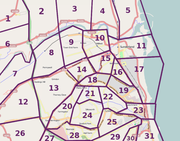
To avoid us all mapping the same area (wasting time and meaning less of an area gets mapped), we divide/slice the area up into a 'cake' and then we can each pick which slice we will map. Sunderland looks in a brilliant state to divide up.
If there is an area you would like to map then you can edit the page and say so, otherwise you can decide when you arrive at the meeting venue.
- Slice number, name, optional comment
- 7, includes Penshaw where someone has helpfully commented that nothing has been mapped, so someone might wantt to map this area for them? [OpenStreetBugs]
- 29, Graham Jones, Can't remember how much there is there. If it's a field it won't take too long so I might need more cake!
- You'd think the tertiary road between 29 and 30 would carry on, but it might not even be a tertiary road. -LastGrape/Gregory
See Also
- Sunderland AFC will be playing Everton at home on the Saturday (4pm) [turned out to be Sunday instead - we foolishly tried to drive past the Stadium of Light at 3pm Ddixon]. This will have a massive impact on the traffic, number of pedestrians, etc. But probably also on things such as hotel availability, etc. There is also a big boxing match on in the city centre on Saturady evening (unrelated to the football ;-) )
Related links follow:
- LwD blog: North East England upcoming events
- LwD blog: Sunderland Maping Party explains what happened.


