TileMill
| TileMill | ||||||||||||||||||||||||||||||||||||||||||||||||||||||||||||||||||||||||||||||||||||||||||||||||||||||||
|---|---|---|---|---|---|---|---|---|---|---|---|---|---|---|---|---|---|---|---|---|---|---|---|---|---|---|---|---|---|---|---|---|---|---|---|---|---|---|---|---|---|---|---|---|---|---|---|---|---|---|---|---|---|---|---|---|---|---|---|---|---|---|---|---|---|---|---|---|---|---|---|---|---|---|---|---|---|---|---|---|---|---|---|---|---|---|---|---|---|---|---|---|---|---|---|---|---|---|---|---|---|---|---|---|
| Author: | MapBox | |||||||||||||||||||||||||||||||||||||||||||||||||||||||||||||||||||||||||||||||||||||||||||||||||||||||
| License: | BSD | |||||||||||||||||||||||||||||||||||||||||||||||||||||||||||||||||||||||||||||||||||||||||||||||||||||||
| Platforms: | macOS, Linux, and Windows | |||||||||||||||||||||||||||||||||||||||||||||||||||||||||||||||||||||||||||||||||||||||||||||||||||||||
| Version: | 1.1.0 (2019-06-05) | |||||||||||||||||||||||||||||||||||||||||||||||||||||||||||||||||||||||||||||||||||||||||||||||||||||||
| Language: | English
| |||||||||||||||||||||||||||||||||||||||||||||||||||||||||||||||||||||||||||||||||||||||||||||||||||||||
| Website: | https://tilemill-project.github.io/tilemill/ | |||||||||||||||||||||||||||||||||||||||||||||||||||||||||||||||||||||||||||||||||||||||||||||||||||||||
| Source code: | https://github.com/tilemill-project/tilemill | |||||||||||||||||||||||||||||||||||||||||||||||||||||||||||||||||||||||||||||||||||||||||||||||||||||||
|
Mapnik webfrontend for custom mapstyles |
||||||||||||||||||||||||||||||||||||||||||||||||||||||||||||||||||||||||||||||||||||||||||||||||||||||||
| ||||||||||||||||||||||||||||||||||||||||||||||||||||||||||||||||||||||||||||||||||||||||||||||||||||||||
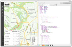
TileMill is a design environment developed by Mapbox for cartography, constituting Mapnik as a renderer, CartoCSS as a stylesheet language, and a locally-served web interface with node.js as a server and based on Backbone.js for the client. Older versions up to 0.10.x are available with a native GUI on all supported platforms. The newer versions since 1.0.x use the browser for the GUI and require a node.js installation, and work on Mac, Ubuntu and Windows.
TileMill works well to load OSM data from a PostGIS database, in addition to loading shapefiles, GeoTIFFs, GeoJSON files, CSV files, both locally and from URLs.
TileMill supports exporting to multiple formats: MBTiles, PDF, PNG, JPG and Mapnik XML configuration files. Mercator is the main supported projection.
In 2015, TileMill was no longer under active development by Mapbox, which replaced it with Mapbox Studio, an online system that uses vector tiles.
In 2016, Mapbox transferred management of the TileMill project to a community of volunteer developers who continue to maintain it. The significant enhancements have been upgrading the library dependencies to keep pace with Mapnik and Carto, as well as improving the static map export functionality. The Kosmtik and Maputnik projects are actively developed alternatives to TileMill.
TileMill works well for individuals looking to render their own custom OpenStreetMap based maps using a simplified interface. The main hurdle to getting a TileMill-OSM environment running is setting up a PostgreSQL database, but which is covered in the installation instructions.
Links
- Project:
- External Guides:
- The Insanely Illustrated Guide To Your First Data-Driven TileMill Map
- TileMill: Open Source Map Design (video)
- Tutorial how to install a database to feed TileMill with raw OSM data working on Windows7.
