Luxembourg/Archive
Postal codes
P&T has given permission to download a file containing the postal codes of all the streets of Luxembourg.This file is published on their homepage. It can be used without any restrictions to complete the postal codes in OSM. --Pierrelu 11:08, 27 September 2010 (BST)
Informationen fir all Ufaenger
Fir all Ufaenger hei kann ech nemmen un d'Herz leen, verdeicht mol am Edit Modus an der "Sandkescht" ronderem ze probeiern wei den Potlatch (numm vum editor vum OSM projee) fonctioneiert, iert se wei well drop lass mapp'en. Och den Wiki ze liesen kann net schuden ech kann ierch do vrun allem dei folgend seiten empfehlen als Anfeierung an d'Matiere: Mapping_techniques ; an ganz besonnesch iert ugefang get mat online editeieren:Editing_Standards_and_Conventions ; an och gudd fir all Fonctionen vum Edit Modus ze kennen: Potlatch/Primer Voila hoffen das domat villen Ufaenger gehollef as! --Petz 16:34, 11 June 2008 (UTC)
Street Names
In Luxembourg, Village names and their signs are bilingual, Luxembourgish and French. One example: French: Bascharage , Luxembourgish: Nidderkäerjeng. Street names generally are only noted in French though. Nevertheless some villages start installing bilingual street signs. Example in French: Rue de Koerich, Luxembourgish: Kärcherwee
The correct tagging would be name = Rue de Koerich name:lb = Kärcherwee
Cycle Routes
Luxembourg has a well organised cycle network, called National cycle route network (Pistes Cyclables). Detailed information can be found at [1]. In addition, there are smaller cycle routes connecting villages. International Cycle Routes are present on some border regions (e.g. SaarLorLux Cycle Route).
Detailed information about my activities on the cycleroute network in Luxembourg you can find on my personal page [2] --Nils Lux 09:18, 16 August 2010 (BST)
Examples of output
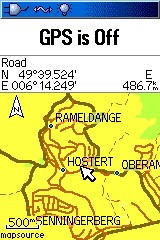
I have uploaded Luxembourg to my Garmin GPS, here is a screenshot of Niederanven which is mapped almost completely. You can find Garmin compatible maps on OSM4You - Luxembourg.
Mapping activity for Luxembourg City
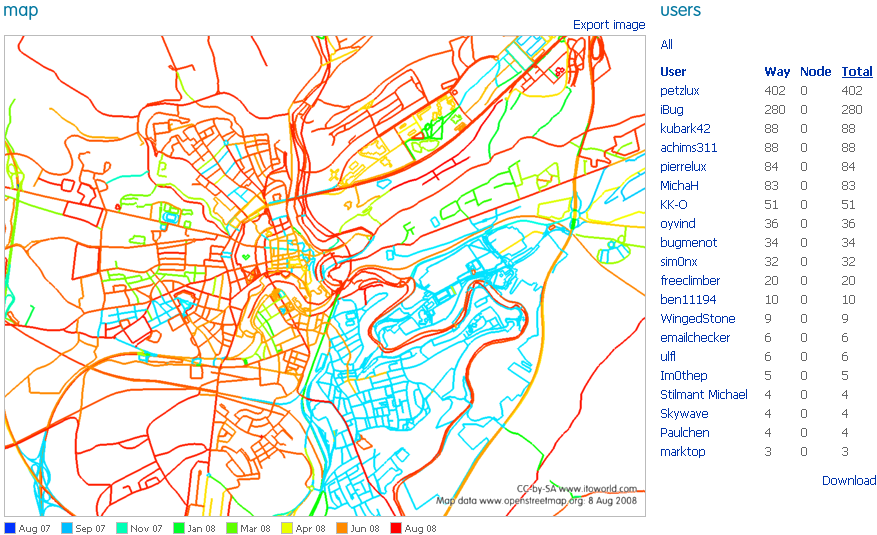
Using the great ITO website , I took this snapshot of mapping activity over the past year for Luxembourg City. This shows the great progress we have been making over the past year. The challenge still lies in filling in the voids and crucially tagging street names.
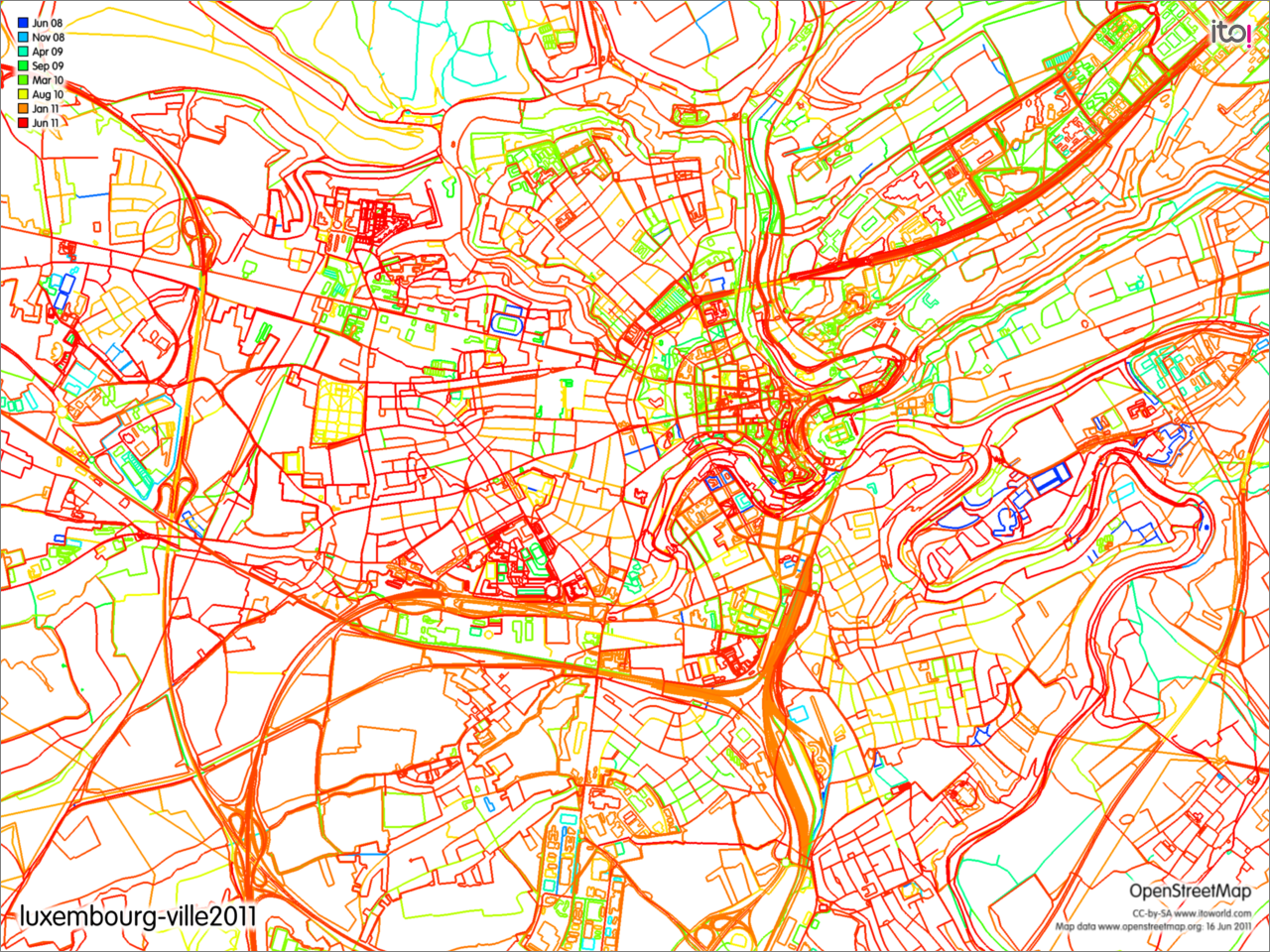
And here you can see how much progress has been made from 2008
Available Data
- Bing has high res aerial imagery for all of Luxembourg . GPS traces for these parts thus are another resource. Street names will still need field investigation.
- Registre national des localites et des rues From the Cadastre, a village, street and address register. Not clear if this is public domain?
- Administration des Ponts et Chaussées has a detailed PDF of the highway network. A routes are motorways, B routes are trunk, N (National) routes are primary and CR (Chemin repris) are secondary. I have been using their data to tag route numbers. According to license on website, data can be used for non commercial purposes as long as attribution is given.
- We are allowed to use the GPS Tracks on [3] made by the user "gusti" [4]
- Le Syndicat d'initiative de la commune de Niederanven nous a permis d'utilser ses traces GPS pour les introduire dans OSM:[5]
Liste of Communes
- BEAUFORT
- BECH
- BECKERICH
- BERDORF
- BERTRANGE
- BETTEMBOURG
- mostly mapped, needs checking and refining possibly--Petz 13:50, 2 September 2008 (UTC)
- BETTENDORF
- BETZDORF
- BISSEN
- BIWER
- BOEVANGE-SUR-ATTERT
- BOULAIDE
- BOURSCHEID
- BOUS
- BURMERANGE
- CLEMENCY
- CLERVAUX
- Clervaux (town) is very inaccurate, many Poi's missing
- villages are ok apart from Marnach where the shopping centre site isnt mapped
- Most unpaved and a view paved tracks missing
- COLMAR-BERG
- CONSDORF
- CONSTHUM
- Consthum and Holzthum should be checked as the Gps data for some new streets, not visible on the aerial pics, didnt match well
- most unpaved ways missing
- CONTERN
- DALHEIM
- DIEKIRCH
- more or less done, needs checking of road names and more details, POI ... --Petz 13:50, 2 September 2008 (UTC)
- DIFFERDANGE
- more or less done, needs checking of road names and more details, POI ... --Petz 13:50, 2 September 2008 (UTC)
- DIPPACH
- DUDELANGE
- more or less done, now checking for POI User: Pierrelu
- ECHTERNACH
- no Yahoo Aerial Coverage, needs GPS traces--Petz 13:50, 2 September 2008 (UTC)
- working on Echternach User:Pierrelu 19:04, 18 October 2008
- I'm in school there so I can update and add tracks and POIs. --User:Ben11194 18:58, 16 December 2008 (UTC)
- ELL
- ERMSDORF
- ERPELDANGE
- ESCH-SUR-ALZETTE
- working on Esch-sur-Alzette musikus
- ESCH-SUR-SURE
- ESCHWEILER
- ETTELBRUCK
- working on Ettelbruck. Know hardly any streetnames though.
- FEULEN
- FISCHBACH
- FLAXWEILER
- FRISANGE
- GARNICH
- GOESDORF
- GREVENMACHER
- GROSBOUS
- HEFFINGEN
- HEIDERSCHEID
- HEINERSCHEID
- Heinerscheid, Lieler and Hupperdange should be checked as streets and Poi's are progressed but inaccurate
- Unpaved ways and tracks missing
- HESPERANGE
- more or less done, needs checking of road names and more details, POI ... --Petz 13:50, 2 September 2008 (UTC)
- HOBSCHEID
- I'm working on this area. User:foxi (since june 2008)
- HOSCHEID
- Villages done but some paved and most unpaved tracks are missing
- HOSINGEN
- mostly done,unpaved ways and tracks missing
- JUNGLINSTER
- more or less done, needs checking of road names and more details, POI ... --Petz 13:50, 2 September 2008 (UTC)
- I live there. --User:Ben11194 13:20, 14 December 2008 (UTC)
- KAYL
- KEHLEN
- KIISCHPELT
- KOERICH
- I'm working on this area. User:foxi (since june 2008)
- KOPSTAL
- LAC DE LA HAUTE-SURE
- LAROCHETTE
- LENNINGEN
- LEUDELANGE
- LINTGEN
- LORENTZWEILER
- LUXEMBOURG
- Working on the following suburbs/areas: Hamm, Pulvermühle, Bonnevoie, Howald ... [iBug]
- Chipped in a bit on the Gare and Kirchberg area --Kenn
- I'm working on Belair, Strassen --LuxBiker 13:53, 10 June 2008 (UTC)
- I registered today some ways along the Péitruss. This area needs to be mapped. Can someone check my uploaded ways? --User:Ben11194 16:38, 21 December 2008 (UTC)
- MAMER
- I'm working on this area --LuxBiker 13:53, 10 June 2008 (UTC)
- MANTERNACH
- MEDERNACH
- MERSCH
- MERTERT
- MERTZIG
- MOMPACH
- MONDERCANGE
- Working on this one -- Nolly 14:56, 6 March 2009 (UTC)
- MONDORF-LES-BAINS
- MUNSHAUSEN
- NEUNHAUSEN
- NIEDERANVEN
- Have added all roads and other features such as churches, industrial/commercial zones and airport detail. Still lacking most road names, cant do them all from memory. Need help!!
- NOMMERN
- PETANGE
- Working here User:Arvoreen
- PREIZERDAUL
- PUTSCHEID
- RAMBROUCH
- RECKANGE-SUR-MESS
- REDANGE/ATTERT
- REISDORF
- REMICH
- ROESER
- ROSPORT
- RUMELANGE
- more or less done, needs checking of road names and more details, POI ... --Petz
- SAEUL
- SANDWEILER
- more or less done, needs checking of road names and more details, POI ... --Petz 13:50, 2 September 2008 (UTC)
- SANEM
- SCHENGEN
- SCHIEREN
- SCHIFFLANGE
- I'm working on this area. User:Stilmant
- SCHUTTRANGE
- more or less done, needs checking of road names and more details, POI ... --Petz 13:50, 2 September 2008 (UTC)
- SEPTFONTAINES
- STADTBREDIMUS
- STEINFORT
- I'm working on this area. User:foxi (since june 2008)
- STEINSEL
- STRASSEN
- I'm working on this area. User:sim0nx
- TANDEL
- TROISVIERGES
- Troivierges itself needs refinement, update on Poi's
- villages are ok
- most unpaved ways in the commune are missing
- footways along castle and abbey not propely mapped
- TUNTANGE
- USELDANGE
- VIANDEN
- more or less done --Petz 13:50, 2 September 2008 (UTC)
- VICHTEN
- WAHL
- WALDBILLIG
- WALDBREDIMUS
- WALFERDANGE
- more or less done, needs checking of road names and more details, POI ... --Petz 13:50, 2 September 2008 (UTC)
- road names added, living there User:dreamlx 11 September 2008
- WEILER-LA-TOUR
- WEISWAMPACH
- WELLENSTEIN
- WILTZ
- needs checking of road names and more details, POI ... --Petz 13:50, 2 September 2008 (UTC)
- WINCRANGE
- WINSELER
- WORMELDANGE


