Concept note
Goal
The main purpose of #MapSudan is to boost the detail of what is mapped in Sudan, with a primary focus on health care and public health management. This can take the form of health services reaching people, so practical navigable assistance to help Health professionals, emergency services and NGOs to reach populations efficiently.
A discussion involving health professionals and mappers based in Britain and Ireland took place on the 14th July 2020 and the discussion looked in general at the state of the map in Sudan. It was generally concluded that Sudan does not have the same progress with completeness of its map as other similar sized/developed African countries, and that the map detail is some way distant from being of any practical use for NGOs on the ground.
The subsidiary goal is to map in harmony with what has already, and is already underway in Sudan's OpenStreetMap database, and to stimulate a more complete map.
Starting Point
The starting point has got to be orientation around Sudan, place-names of all sorts of settlements. This can be achieved using out of copyright maps, or otherwise maps to be agreed for use under the standard OpenStreetMap terms of licence CC-BY-SA. There are various options for these maps, and place-name mapping is a relatively easy task to do, without a lot of training. It can also be done by remote mappers outside of Sudan, and the methodology is simply to harvest place names from printed maps, and insert them into the database using the place=* and name=* tagging convention.
Some options exist for this sort of resource with the Sudan National Survey Authority out of copyright 1:10,000 series or with other maps available from the British Library [subject to licence waiver].
Maturation
There are two next level initiatives which can work in parallel. These require a little more expertise and knowledge of OpenStreetMap tagging conventions. These are:
- Mapping highways to each settlement and connecting each place to the transport network, where it is possible to verify that such a connection exists. The further requirement would be to map, if possible details about the road surfaces.
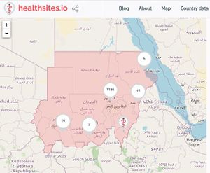
- Mapping further health care service points. At the present time the health sites project has recorded 301 hospitals, 809 Pharmacies, 90 clinics, 13 Doctors (GPs) and 17 Dentists (it is very clear that this is incomplete). This kind of information can only be added and maintained by an animated local mapping community.
Participation
The partnership should be as inclusive as possible, and will involve for example local persons living in Sudan, foreign and local NGOs, the Sudanese diaspora, and in particular youth mappers in Sudan. To ensure that this happens a particular effort will be made to engage the University teachers and student bodies in Sudan in awareness of the empowering and participatory governance of mapping. The aim will be to recruit and form these into a formal youth mapper chapter, so as to leave a sustainable and permanent in-country capacity to improve, update and develop the map.
Initially the project will be an un-funded crowdsource seeking support from the OpenStreetMap community, the HOTOSM networks, and then would develop as a Sudanese based community organisation in its own right. For the starting phase social media can be used to raise awareness of the project, and recruit participants.
Future Projects
Once there is a local chapter future projects with a health focus will be consulted upon and discussed with those on the ground in Sudan as the primary stakeholders. These could include (list not exhaustive):
- An FGM focussed project similar to what is being done with Crowd2map in Tanzania
- A road safety project, with a focus on mapping to help prevent road traffic accidents
- An environmental management or physical planning project similar to #MapLesotho
- A strategic spatial data focus between the Heath Authorities and OpenStreetMap contributors similar to Health Sites in Senegal

