Proposal:Pedestrian river crossing
| Pedestrian river crossing | |
|---|---|
| Proposal status: | Draft (under way) |
| Proposed by: | AHarvey |
| Tagging: | water_crossing_level:foot=* |
| Applies to: | |
| Definition: | Documents the typical grade of the river crossing |
| Statistics: |
|
| Draft started: | 2022-01-26 |
Proposal
To tag a pedestrian stream or river crossing grade, in terms of how wet you'll get on either a node or way where highway=footway or highway=path and a waterway=* intersect.
This proposal is limited to just the water level of the river crossing, how much you'll get wet. There are other important considerations around flow rate and temperature though these are out of scope for this proposal.
Rationale
Particularly on hiking trails, the intersection of a highway=footway or highway=path and a waterway=* can be defined as either:
- A bridge bridge=yes which allows you to walk over the watercourse.
- A culvert tunnel=culvert which takes the water through a tunnel underneath the walking path.
- Stepping stones ford=stepping_stones which allow you to walk through the watercourse without usually getting wet (unless the water level is higher than the stepping stones, this tag doesn't imply you'll always be able to get across)
- A generic stream/river crossing ford=yes where your path passes through the watercourse.
In the last case of ford=yes it can be helpful to describe the usual condition of that stream/river crossing to help give consumers an idea of what they can generally expect.
Mindful that conditions can change depending on upstream rainfall, or it could vary seasonally, but for places where it's usually consistent, this proposal proposes tagging it.
depth=*
There already exists depth=* to tag the water depth in meters, however surveying that is more difficult compared to the proposed values here. Given some data consumers may prefer categorised values rather than raw depth measurements, there is still value in having both tags.
Tagging
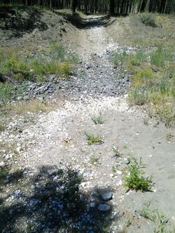
- water_crossing_level:foot=dry: creek/stream crossing where generally the creekbed is dry and you won't get wet.
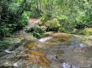
- water_crossing_level:foot=step_over: creek/stream crossing where generally you can step over the waterway, potentially making use of stones or logs to keep dry.
- water_crossing_level:foot=wet_soles: creek/stream crossing where generally the water level is so low that you won't have water ingress in your shoes (even with joggers).
- water_crossing_level:foot=ankle_deep: creek/stream crossing where generally the water level is low but depending on if you have joggers or hiking boots and the waterproof quality your feet may or may not get wet.
- water_crossing_level:foot=knee_deep: creek/stream crossing where your body will stay dry but you'll want to take your shoes off if you prefer to keep them dry
- water_crossing_level:foot=wade: river crossing where your body will get wet, may have a rope to help you cross, but you can wade through the water and won't usually need to swim
- water_crossing_level:foot=swim: river crossing where you'll need to swim across
These values are intended as typical scenarios, sparing sporadic weather events like droughts or floods.
You could use water_crossing_level:foot:min=* and water_crossing_level:foot:max=* to describe typical range (exclude extreme events because every water body would be min=dry and max=swim at extreme events).
Examples
| water_crossing_level:foot | |
|---|---|
| dry | 
|
| step_over | 
|
| wet_soles | 
|
| ankle_deep | |
| knee_deep | |
| wade | |
| swim |
Rendering
This proposed tag is limited only to how much you'll get when on a river crossing, it's not actually a tag to say there is a river crossing here. There could be other tags to indicate other aspects of the crossing like safety line, temperature, typical flow rate. Therefore this tag alone shouldn't trigger any particular rendering.
Features/Pages affected
External discussions
Status
This proposal is currently in early draft stage, taking in wider feedback and discussion. Before the tag is formally proposed it would be nice to see it in use in the OSM database.
Comments
Please comment on the discussion page.
