Deriviste
Jump to navigation
Jump to search
| Deriviste | ||||||||||||||||||||||||||||||||||||||||||||||||||||||||||||||
|---|---|---|---|---|---|---|---|---|---|---|---|---|---|---|---|---|---|---|---|---|---|---|---|---|---|---|---|---|---|---|---|---|---|---|---|---|---|---|---|---|---|---|---|---|---|---|---|---|---|---|---|---|---|---|---|---|---|---|---|---|---|---|
| Author: | Richard Fairhurst | |||||||||||||||||||||||||||||||||||||||||||||||||||||||||||||
| License: | WTFPL with no warranty | |||||||||||||||||||||||||||||||||||||||||||||||||||||||||||||
| Platform: | Web | |||||||||||||||||||||||||||||||||||||||||||||||||||||||||||||
| Version: | 5.0[1] (2020-05-09) | |||||||||||||||||||||||||||||||||||||||||||||||||||||||||||||
| Language: | English
| |||||||||||||||||||||||||||||||||||||||||||||||||||||||||||||
| Website: | osm.cycle.travel/deriviste | |||||||||||||||||||||||||||||||||||||||||||||||||||||||||||||
| Source code: | https://github.com/systemed/deriviste | |||||||||||||||||||||||||||||||||||||||||||||||||||||||||||||
| Programming language: | JavaScript | |||||||||||||||||||||||||||||||||||||||||||||||||||||||||||||
|
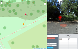
Deriviste is a editor for adding POIs directly from street-level imagery (Mapillary). |
||||||||||||||||||||||||||||||||||||||||||||||||||||||||||||||
| ||||||||||||||||||||||||||||||||||||||||||||||||||||||||||||||
Deriviste is a proof-of-concept OpenStreetMap editor for adding POIs directly from street-level imagery (Mapillary).
The author encourage you to clean up with a real editor after adding POIs.
You cannot see what is missing from the database if it is not rendered on the standard map (OSM Carto).
Seems like this editor has not been working as of April 2022, or possibly even earlier[2].
External links
- (en) Intro to Deriviste and OpenStreetMap
- (en) Video tutorial on YouTube
- (en) Video tutorial on YouTube
- (en) Interview: Richard Fairhurst, maker of Deriviste
- (fr) Contribuer avec Mapillary et Deriviste
