File:Buildings conflation-imagery comparison.png
Jump to navigation
Jump to search


Size of this preview: 800 × 446 pixels. Other resolutions: 320 × 179 pixels | 640 × 357 pixels | 1,024 × 571 pixels | 1,280 × 714 pixels | 2,260 × 1,261 pixels.
Original file (2,260 × 1,261 pixels, file size: 362 KB, MIME type: image/png)
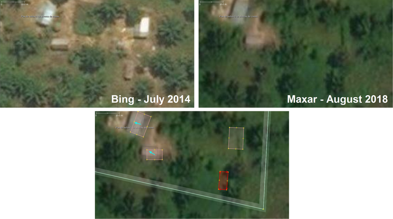
Bing and Maxar imagery comparison while conflating buildings in JOSM
Licensing
![]()
This file is a screenshot of the software JOSM, with imagery in background. It may include OpenStreetMap data, in such case ODbL license also applies.
Imagery in background:

![]()
"JOSM" (Java OpenStreetMap Editor – josm.openstreetmap.de) is free software released under the terms of the GNU General Public License as published by the Free Software Foundation; either version 2 of the license, or any later version.
![]()
![]()
This image is composed entirely, or almost entirely, of Bing aerial imagery.
Bing imagery is not open licensed, but is generously made available to the OpenStreetMap project for deriving open licensed map data in editors such as JOSM, iD or Vespucci. This upload is not covered by permission described at Bing Maps, as OSM Wiki cannot be interpreted as "editor application" and "We require you use access credentials to use the service and require use of transaction tracking and/or session tracking methods for all uses of the service" is not fulfilled.
This image is a relatively minor extract of the (worldwide) Bing imagery, used for illustrative purposes on the OpenStreetMap wiki, to help document ways of using and interpreting the imagery in the OpenStreetMap mapping process.
This image is a relatively minor extract of the (worldwide) Bing imagery, used for illustrative purposes on the OpenStreetMap wiki, to help document ways of using and interpreting the imagery in the OpenStreetMap mapping process.
![]()
![]()
This image is composed entirely, or almost entirely, of Maxar aerial imagery.
Maxar imagery is not open licensed, but is generously made available to the OpenStreetMap project for deriving open licensed map data. This upload is not certain to covered by permission described at Maxar ("you may only use our imagery to trace, and validate edits that must be contributed back to OSM. You cannot download our imagery or use our imagery for any other purpose.".) Maybe this use can fit under "validate edits"?
This image is a relatively minor extract of the (worldwide) Maxar imagery, used for illustrative purposes on the OpenStreetMap wiki, to help document ways of using and interpreting the imagery in the OpenStreetMap mapping process.
This image is a relatively minor extract of the (worldwide) Maxar imagery, used for illustrative purposes on the OpenStreetMap wiki, to help document ways of using and interpreting the imagery in the OpenStreetMap mapping process.
| Contains map data © OpenStreetMap contributors, made available under the terms of the Open Database License (ODbL).
The ODbL does not require any particular license for maps produced from ODbL data, produced maps may be subject also to other licences. |
File history
Click on a date/time to view the file as it appeared at that time.
| Date/Time | Thumbnail | Dimensions | User | Comment | |
|---|---|---|---|---|---|
| current | 10:00, 13 July 2020 | | 2,260 × 1,261 (362 KB) | Claire Halleux (talk | contribs) |
You cannot overwrite this file.
File usage
The following 2 pages use this file: