File:Wrexham b&a.png

Original file (2,354 × 699 pixels, file size: 1.89 MB, MIME type: image/png)
Summary
| Description | Solar power mapping in Wrexham June & August 2020 |
|---|---|
| Author | SK53 |
| Source | OSM |
| Date | 2022-08-11 |
| Permission | OdBL |
Description
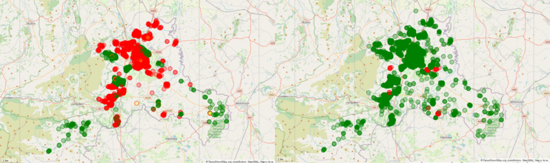
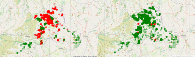
Solar power mapped on OpenStreetMap in the Welsh borough of Wrexham (excluding solar farms mapped as power=plant). Red elements lack detailed tagging for orientation (direction=* or module count generator:solar:modules=*.
Wrexham was originally mapped to a good degree of completeness (>80% of predicted values in 2019), but without detailed tagging. Subsequently in 2022 a more systematic search of all parts of the borough (based on a clustering of buildings) resulted in improving this by around 25% (i.e., close to 100% of predicted coverage). The main thing to note is that there is much more dispersion in position of solar panels: often a better indicator of how comprehensive coverage might be than a raw comparison of completeness.
Licensing
| Contains map data © OpenStreetMap contributors, made available under the terms of the Open Database License (ODbL).
The ODbL does not require any particular license for maps produced from ODbL data, produced maps may be subject also to other licences. |
File history
Click on a date/time to view the file as it appeared at that time.
| Date/Time | Thumbnail | Dimensions | User | Comment | |
|---|---|---|---|---|---|
| current | 14:51, 12 August 2022 | 2,354 × 699 (1.89 MB) | SK53 (talk | contribs) | {{Information | description=Solar power mapping in Wrexham June & August 2020 | source=OSM | date=2022-08-11 | author=SK53 | permission=OdBL | other_versions= }} |
You cannot overwrite this file.
File usage
There are no pages that use this file.