Fremont CA Buildings Import
Jump to navigation
Jump to search
Goal: Import buildings from Fremont City GIS data into OSM (~60K buildings)
Data compatibility: permission obtained in private communication
Data source: http://egis-cofgis.opendata.arcgis.com/datasets/5b4a263844634084af2001f82a5174a5_0 (not accessible as on 10/17/2020)
Stage: in process
Overview:
- Intersect the OSM-layer with GIS-layer, exclude any GIS building that intersects existing OSM-buildings.
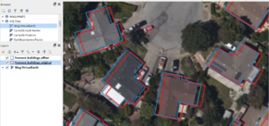
- Use the Microsoft building footprint layer to correct for offset. First, find for each GIS-building, if possible, a corresponding MS-buildings and compute the distance between the centroids of the two buildings (i.e. offset). After that, for each GIS-building compute the median offset for the nearest 30 buildings and use this median offset to shift the given GIS-building. The assumption behind this step is that MS layer is mostly unbiased, yet, has course geometries, while the GIS layer, has detailed geometries, yet, also has some bias that may need to be corrected.
- Orthogonolize the GIS-geometries by solving the following constrained optimization problem: minimize the total Euclidean norm of vectors by which each point of the original polygon needs to be moved in order to make all angles of the polygon equal to either 90- or 180 degrees. Use the resulting squared geometry only if the Hausdorff distance between the resulting and the original geometry is less than 1 meter (otherwise use the original geometry). In other words, if the resulting geometry is VERY different from the original one then it may mean that the building's shape may have some non-90-degree angles/curves and squaring should not be applied.
Code, inputs, outputs: https://mega.nz/folder/CglwnBaA#P5QE3LMzzhXNLgIznhaPpw
OSM account for import: Yury_Yatsynovich_--_OSM_Imports
