GPSBabel
Jump to navigation
Jump to search
| GPSBabel | ||||||||||||||||||||||||||||||||||||
|---|---|---|---|---|---|---|---|---|---|---|---|---|---|---|---|---|---|---|---|---|---|---|---|---|---|---|---|---|---|---|---|---|---|---|---|---|
| License: | GNU GPL | |||||||||||||||||||||||||||||||||||
| Platforms: | Windows, Linux, and macOS | |||||||||||||||||||||||||||||||||||
| Website: | https://www.gpsbabel.org/ | |||||||||||||||||||||||||||||||||||
| Source code: | https://github.com/gpsbabel/gpsbabel | |||||||||||||||||||||||||||||||||||
| Programming language: | C++ | |||||||||||||||||||||||||||||||||||
|
GPS data converter |
||||||||||||||||||||||||||||||||||||
| ||||||||||||||||||||||||||||||||||||
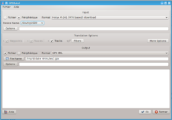
GPSBabel is a crossplatform tool that can convert between the various data formats of GPS traces. There is no single standard among devices and software, but in most cases converting waypoints and tracks to GPX format is enough. GPSBabel also can:
- Handle multiple input files at once
- Apply filters (conditionally add/remove points) during convertion
- Communicate with connected to computer GPS-devices
GPSBabel is non-interactive a command line application, but it has several GUI:
- Built-in, written in Qt
- Alternative Qt GUI Gebabbel
- Web-interface gpsvisualizer.com

