GPX slippy map
This renders GPX files on-the-fly to a transparent slippy-map layer, allowing you to browse tracklogs in more detail than the existing preview image.
Front page is at:
http://dev.openstreetmap.org/~ojw/gpx/list.php
Note thas to find the .gpx ID, you have to go to your own gpx page and try to download it. Something like 1234567.gpx will be proposed, the first 7 numbers are the ID.
Or browse to a URL of the form:
http://dev.openstreetmap.org/~ojw/gpx/?gpx=[the GPX trace ID]
e.g.
http://dev.openstreetmap.org/~ojw/gpx/?gpx=113257
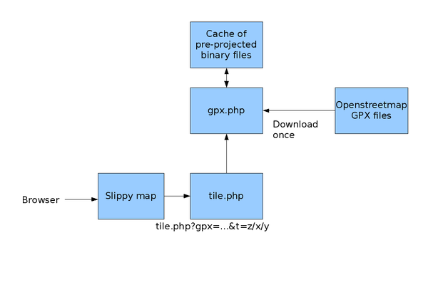
Overview
Source code
Download from:
http://svn.openstreetmap.org/applications/rendering/gpx_slippy_map/
revision history is viewable at:
http://trac.openstreetmap.org/browser/applications/rendering/gpx_slippy_map
Benchmarks
For a 9999-point tracklog:
- Render tile containing data: 140 ms
- Download and process new tracklog: 800ms
- Render tile without data: 3 ms
Optimisations done
- check if bounding box is completely outside the tile, and if so don't draw anything
- precalculate mercator projections when storing tracklog, rather than when drawing tile
- save some space by storing points as integer not floating point
Optimisations to do
- Support for gziped gpx files i.e. 2009_03_29_1600.gpx.gz
please add any suggestions here
How you can help
- If someone could setup a cache in front of the tileserver that would be great (i.e. subsequent HTTP requests for the same tile should come from your disk not from dev server)
- GPX tiles never expire if that helps your caching policy (because a given GPX-id/x/y/z will always return the same image unless the rendering software changes)
Binary file format
# +---------+--------+------+--------------------------+
# | size    | type   | name | description              |
# +---------+--------+------+--------------------------+
# | 4 bytes | int    | n    | number of trackpoints    |
# | 8 bytes | double | xmin | bounding box (W)         |
# | 8 bytes | double | xmax | bounding box (E)         |
# | 8 bytes | double | ymin | bounding box (S)         |
# | 8 bytes | double | ymax | bounding box (N)         |
# +---------+--------+------+--------------------------+
#   then n pairs of:
# +---------+--------+------+--------------------------+
# | 4 bytes | int    | x    | coded position           |
# | 4 bytes | int    | y    | coded position           |
# +---------+--------+------+--------------------------+
#
# xmin,xmax,ymin,ymax,x,and y are stored as positions
# relative to the coverage of the slippy map system
#
# x positions from 0 = 180 degrees west to 1 = 180 degrees west
# y positions from 0 = 85.0511 north to 1 = 85.0511 south
#
# note that these are in the mercator projection, i.e.
# dLat/dy is not constant
#
# encoding of x and y:
# the positions described above are divided by 2^31 for
# storage as an integer,
# i.e.:
#  x: 0 = fully west, to 2^31-1 = fully east
#  y: 0 = fully north, to 2^31-1 = fully south
#
# integers are big-endian
# double-precision floats are platform-dependant
