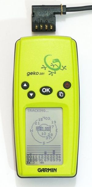
The Garmin Geko series has been discontinued and is no longer available to buy from Garmin.
Geko 101
Basically a geko 201 but without the connector so you can't get data off it.
| Garmin Geko 101
|
| Description
|
|
| GNSS
|
12 channels
augmentation: no
|
| Memory
|
Internal: no (3000 max logging). External: ? no.
|
| Connectivity
|
no
|
| Features
|
 addresses addresses
|
 points of interest points of interest
|
 mass storage mode mass storage mode
|
 Waterproof Waterproof
|
|
Geko 201
| Garmin Geko 201
|
| Description
|
receiver
|
| GNSS
|
12 channels
augmentation: waas;egnos
|
| Memory
|
Internal: no (10000 max logging). External: ? no.
|
| Connectivity
|
rs232
|
| Batteries
|
2*AAA (12hrs lifetime)
|
| Features
|
 addresses addresses
|
 points of interest points of interest
|
 mass storage mode mass storage mode
|
 Waterproof Waterproof
|
|
| Pros
|
- Pretty cheap and small.
- 10000 point memory for track logs, with recording interval highly configurable (by time, distance, or 'auto' which works in a similar way to the eTrex; and with adjustable resolution). The auto mode has selectable resolution and only makes points when you change direction/altitude. When driving around town, auto mode only needs to create a point about every 8 seconds giving 22 hours continuous-use memory!
- Waterproof to 3m
- Happy running on Ni-MH batteries
- Fits standard Garmin serial/power cable
- Fits standard Garmin vehicle / bicycle mounts
- rather robust, my 301 dropped of the car at about 50km/h two year ago and survived.
- Should work well on the dashboard, tucked up by the windscreen. Rubberised back keeps it still. Location repeatability usually within 6ft on mine, even when it says 20ft. I put it on driver's side then try to keep it aligned with center of road.
- Cigarette lighter and data power cord combined available.
- Fluorescent green/yellow front makes it easy to find.
- Small and light enough to attach to car roof with blu-tack for best possible satellite lock and accuracy.
- Clear, high-contrast display makes it easy to read on a bike. IMO, best bike option.
- Supports recording track points based on distance. These are economical for the server and give a matched resolution. The mode saves recording unnecessary points when waiting at bus stop or at a junction. I use the following recording intervals: Towns: 20ft, Unmapped countryside 40-80ft, Motorways 240ft. For these three modes, the Geko has enough memory for 38, 76-152, 454 miles respectively.
|
| Cons
|
- Entering waypoint names is a real pain and they can only be 6 characters long. It's better to use a pen and paper and make a list of waypoint number (generated automatically by the geko) and what it represents, or use Audio mapping
- Keys are too small to use it with gloves
- Battery life significantly worse than equivalent eTrex, and 'remaining battery' indicator rather erratic. If going out in the cold, NiMh battery terminal voltage seems to drop causing low battery indication. I recommend UniRoss 900mah NiMh cells, they seem to have a slightly higher terminal voltage than others.
- Display font used for longitude and latitude waypoint coordinates is very small. This is partially compensated for by decent screen contrast, but this might be an issue for users with poor eyesight. More committed users using the (optional) data cable to transfer the coordinates to their computers will probably not be affected by this very much.
- The Geko series has an excellent capability for accumulating an "Active Track" and can acquire up to 10,000 track-points until it starts rewriting the previous data. While in the active track mode the unit will save the track exactly as received including positional errors from initial satellite tracking, restricted satellite view and other bad conditions. Saving the active track as a "saved track" will subject the raw active track data to an internal process that will average the tracking errors present, refine the raw data eliminating unnecessary track points and reduce the tracklog to 500 points or less. This results in a much smaller, but more accurate and usable tracklog.
|
The geko is a small, cheap unit that runs off two AAA batteries with maybe 12 hours of life. It has a backlight and a 12 channel parallel receiver and can record tracks at a point per second. The standard garmin serial cable allows you to get tracks and waypoints off it with, for example, gpsbabel. See How to get data from a Geko 201. Supports WAAS and European equivalent EGNOS (May need fw upgrade to 2.50) for improved accuracy.
Full reset
The 201 is capable of EGNOS reception (2.50+ firmware), but depending on when you first enabled WAAS mode it may have locked onto the wrong satellites, meaning you never get a differential lock. This can be cured with a full reset, which you can do by turning the unit off, then holding OK, page and power. It will then ask you to confirm the reset. This wipes everything, including waypoints, owner information etc. Once reset, re-enable WAAS mode via Setup->System, and leave the unit with a clear view of the sky for 15 minutes. If all goes well, you'll see the "accuracy: 14ft" line replaced with something like "diff: 7ft" and a peppering of 'D's on the satellite display.
Geko 301
| Garmin Geko 301
|
| Description
|
receiver
|
| GNSS
|
12 channels
augmentation: waas;egnos
|
| Memory
|
Internal: no (10000 max logging). External: ? no.
|
| Integrated equipment
|
compass, altimeter
|
| Connectivity
|
rs232
|
| Features
|
 addresses addresses
|
 points of interest points of interest
|
 mass storage mode mass storage mode
|
 Waterproof Waterproof
|
|
A Geko 201, with a magnetic compass and a pressure altimeter. This is not very useful for OSM datalogging, but very convenient for navigation and Geocaching.

