Goosm
The given reason is: I do not see any significant impact on the historic development of OSM by this app. We can delete this page, can't we? --Nakaner (talk) 15:55, 8 October 2024 (UTC).
| Goosm | ||||||||||||||||||||||||||||||||||||||||||||||||||||||||||||||||||||||||||||||||||||||||||||||||||||||||||||||||||||||||||||||||||||||||||||||||||
|---|---|---|---|---|---|---|---|---|---|---|---|---|---|---|---|---|---|---|---|---|---|---|---|---|---|---|---|---|---|---|---|---|---|---|---|---|---|---|---|---|---|---|---|---|---|---|---|---|---|---|---|---|---|---|---|---|---|---|---|---|---|---|---|---|---|---|---|---|---|---|---|---|---|---|---|---|---|---|---|---|---|---|---|---|---|---|---|---|---|---|---|---|---|---|---|---|---|---|---|---|---|---|---|---|---|---|---|---|---|---|---|---|---|---|---|---|---|---|---|---|---|---|---|---|---|---|---|---|---|---|---|---|---|---|---|---|---|---|---|---|---|---|---|---|---|---|
| Author: | Medianovens | |||||||||||||||||||||||||||||||||||||||||||||||||||||||||||||||||||||||||||||||||||||||||||||||||||||||||||||||||||||||||||||||||||||||||||||||||
| License: | (free of charge) | |||||||||||||||||||||||||||||||||||||||||||||||||||||||||||||||||||||||||||||||||||||||||||||||||||||||||||||||||||||||||||||||||||||||||||||||||
| Platform: | Android | |||||||||||||||||||||||||||||||||||||||||||||||||||||||||||||||||||||||||||||||||||||||||||||||||||||||||||||||||||||||||||||||||||||||||||||||||
| Status: | Broken | |||||||||||||||||||||||||||||||||||||||||||||||||||||||||||||||||||||||||||||||||||||||||||||||||||||||||||||||||||||||||||||||||||||||||||||||||
| Version: | 1.0.4 (2014-06-22) | |||||||||||||||||||||||||||||||||||||||||||||||||||||||||||||||||||||||||||||||||||||||||||||||||||||||||||||||||||||||||||||||||||||||||||||||||
| Languages: | French, English, and ...
| |||||||||||||||||||||||||||||||||||||||||||||||||||||||||||||||||||||||||||||||||||||||||||||||||||||||||||||||||||||||||||||||||||||||||||||||||
| Install: | ||||||||||||||||||||||||||||||||||||||||||||||||||||||||||||||||||||||||||||||||||||||||||||||||||||||||||||||||||||||||||||||||||||||||||||||||||
|
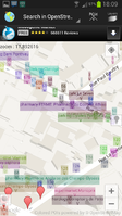
Contains an advanced search engine for POIs. Search any tags and display matching results, then send their position to any application that support intent filters if needed (google streetview, waze, navit, etc.). Create, Update or delete a POI, in two clicks. Autocomplete with most often-used tags, or use custom tags. |
||||||||||||||||||||||||||||||||||||||||||||||||||||||||||||||||||||||||||||||||||||||||||||||||||||||||||||||||||||||||||||||||||||||||||||||||||
| ||||||||||||||||||||||||||||||||||||||||||||||||||||||||||||||||||||||||||||||||||||||||||||||||||||||||||||||||||||||||||||||||||||||||||||||||||
| Discontinued. Goosm is no longer maintained nor available on Google Play Store. |
Goosm was a free map application for Android that uses Google Maps for the default map but Nominatim for searching.
Long click anywhere to display instantly the address and coordinates of a point. You can then send the position to any application that supports intent filters (waze, navit, google streetview, ...)
The list of supported apps is often updated. You can send your requests to the developer.
You can save several positions in the database, and give it a name. You can also place a marker by inputting its coordinates.
There are several layers (Normal, Satellite, Terrain, Hybride, Openstreetmap).
You can use google geocoder service to look for street names, and use an advanced search engine to look for points of interest in Openstreetmap. (e.g. you can search POIs for asian cuisine, or for a 4-5 stars hotel ... etc. You can search around you within a radius, or in the visible region of the map, or all around the world).
Anyone can create or update a POI, after having created a (free) openstreetmap account. Select the OpenstreetMap layer, do a long click to create a new marker or click an existing marker displayed by the search engine, click on the infowindow, and select "edit in Openstreetmap". Add or edit the existing tags, click OK and that's it.
There is also a reminder that will help you to remember where you parked your car. Just go in the "car position" menu and long click on the map to place your car. When you come back to the application, in the "car position" menu, click on the lower left button to locate your car.
