Hartlepool
| V・T・E |
| latitude: 54.683, longitude: -1.211 |
| Browse map of Hartlepool 54°40′58.80″ N, 1°12′39.60″ W |
| Edit map |
|
External links:
|
| Use this template for your locality |
Hartlepool is a town in County Durham at latitude 54°40′58.80″ North, longitude 1°12′39.60″ West.
Hartlepool is a town and unitary authority in the North East region of England. Together with the three unitary authorities of Durham, Darlington and Stockton-on-Tees (north of the river) it forms the ceremonial county of County Durham.
Progress
The end is in sight! Although Laura got bored and stopped coming out mapping with me, Benjamin likes a bike ride (in his trailer), so although it is exhausting, we are making progress on Sunday mornings. Southern Hartlepool is now complete, and the vast majority of Northern Hartlepool is too - just Clavering left!
As Benjamin and I have cycled most of the roads on the map, I will have to work out how many kilometers we have cycled to complete the map...
According to my OSM database of Hartlepool, the town currently (14 Feb 2010) contains the following total lengths of roads etc. (rounded to nearest km):
- Motorways - 0 km (correct)
- Trunk - 21 km (this is because someone has shown the A689 as Trunk)
- Primary - 66 km
- Secondary - 14 km
- Tertiary - 75 km
- Unclassified - 99 km
- Residential - 277 km
- Total Roads - 553 km
In addition there are 9km of tracks, 48 km of cycleways and 57 km of footways.
These look reasonable to me, but I am surprised at how big the totals are for cycleways and footways - I think I must have included some of the Hart-Haswell Cycleway to get this total, plus there is a long route along the sea front.
The SQL required to calculate the total is:
select sum(st_length(way))/1000 as total_roads from planet_osm_line where highway='motorway' or highway='motorway_link' or highway='trunk' or highway='trunk_link' or highway ='primary' or highway='primary_link' or highway='secondary' or highway='tertiary' or highway='unclassified' or highway='service' or highway='residential';
The map that produced these totals can be seen at http://www.townguide.webhop.net/output/80/townguide_poster.pdf.
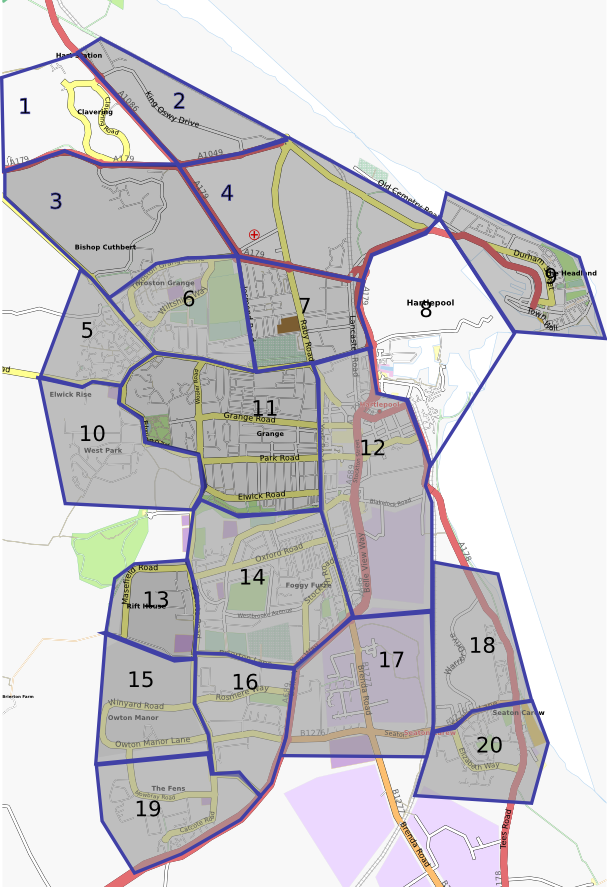
Mapping Areas
Things To Do
- 1:
Clavering (Complete June 2010) - 2:
Hart Station (King Oswy) (Complete 02 May 2010) - 3:
Bishop Cuthbert (Complete 13 September 2009) - 4:
Central Estate/West View (Complete June 2010) - 5:
Posh Aldi Estate (Complete 12 April 2009) - 6:
Throston (Complete 11 April 2009) - 7:
Dyke House (Complete 28 Feb 2010) - 8:
Marina Area (Done, but no detail of docks - want to check a couple of road names) - 9:
Headland (Complete April 2010) - 10:
West Park (Done - Complete 30 April 2009) - 11:
Grange Area (Complete 20 September 2009) - 12:
Stranton (Complete Feb 2010) - 13:
Rift House (Done - Complete 21 June 2009) - 14:
Foggy Furze (Complete May 2009) - 15:
Owton Manor (Complete Jan 2010) - 16:
Rosmere (Complete Jan 2010) - 17:
Industrial Estates (Complete Feb 2010) - 18:
North Seaton Carew (Completed 21 May 2009) - 19:
The Fens (Completed Jan 2010) - 20:
South Seaton Carew (Completed 21 May 2009)

