Key:mountain_pass
| Description |
|---|
| Marks the highest point of a mountain road, railway or path as it passes over a crest. |
| Group: properties |
| Used on these elements |
| Documented values: 1 |
| Useful combination |
| See also |
| Status: approved |
| Tools for this tag |
|
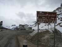
mountain_pass=yes marks the highest point of a mountain road, railway or path as it passes over a crest.
In common usage the term "mountain pass" is ambiguous (see ![]() mountain pass). The meaning can be a highway (road, footway, etc.) passing over a mountain or the topopgraphic saddle point. Unlike in common usage OpenStreetMap clearly differentiates between these two concepts. The notion introduced here is the highway.
mountain pass). The meaning can be a highway (road, footway, etc.) passing over a mountain or the topopgraphic saddle point. Unlike in common usage OpenStreetMap clearly differentiates between these two concepts. The notion introduced here is the highway.
A mountain_pass=yes tag should be the highest point of the way, so it's a single node on that way. For the topopgraphic saddle point see natural=saddle. Be aware that highways don't always go exactly through the saddle point, so that the highest point on the highway and the saddle point can have different positions.
Usage
Applies to the "highest node" on a railway or highway = motorway/secondary/footway/... (could be any appropriate type of highway):
- mountain_pass=yes
- name=Brennerpass
- ele=1370 (metres above sea level)
Lots of passes are the border between two countries and therefore have names in (at least) two languages. These names should be tagged, e.g. name:it=Passo dello Stelvio and name:de=Stilfserjoch (but keep in addition a simple name=Passo dello Stelvio where possible, otherwise simple renderers may display no name at all). The corresponding language abbreviations can be found at ![]() ISO639-1 codes.
ISO639-1 codes.
Example:
- mountain_pass=yes
- name:de=Stilfserjoch
- name:it=Passo dello Stelvio
- name=Stilfserjoch
- ele=2760
Optional:
- wikipedia=* - A lot of the well-known passes have dedicated Wikipedia pages.
- opening_hours=* - Example: Apr-Oct: 24/7
- rtsa_scale=1A - category of the difficulty of the soviet-russian classification system
