Seamarks/Leading Lines
The tags defined on this page will render in various nautical charts.
This page defines tag values for navigation line and recommended track objects.
Categories
| Category (CATNAV) | seamark:navigation_line:category | Definition |
|---|---|---|
| Clearing line | clearing | A straight line that marks the boundary between a safe and a dangerous area or that passes clear of a navigational danger. |
| Transit line | transit | A line passing through one or more fixed marks. |
| Leading line | leading | A line passing through one or more clearly defined objects, along the path of which a vessel can approach safely up to a certain distance off. |
| Category (CATTRK) | seamark:recommended_track:category | Definition |
|---|---|---|
| Based on a system of fixed marks | fixed_marks | A straight route (known as a recommended track, range or leading line), which comprises at least two structures (usually beacons or daymarks) and/or natural features, which may carry lights and/or top-marks. The structures/features are positioned so that when observed to be in line, a vessel can follow a known bearing with safety. |
| Not based on a system of fixed marks | no_fixed_marks | A route (known as a recommended track or preferred route) which is not based on a series of structures or features in line. |
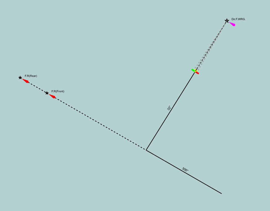
Navigation lines and recommended tracks are mapped as ways (usually just two nodes) laying along the path where the objects are to be displayed. The way should carry the tags for correct rendering. Nodes belonging to other objects, such as leading lights, may be used. The following illustration shows two navigation lines and two recommended tracks. The latter carry seamark:recommended_track:orientation=... tags in order for the bearing to be displayed. The values are decimal numbers, representing the bearing in degrees true.
Do not use these objects to map fairway centrelines. Remember, these objects are straight lines and should normally have only two nodes. Both types must project to a pair of transit objects or other directional object, otherwise they are not navigationally useful. Fairways should be mapped as areas and should not have a separately mapped centreline.
References
OSM seamark resources
- Seamark tag values(en)
- Seamark objects(en)
- Seamark attributes(en)
- Categories of objects(en)
- INT-1 cross reference(en)
- Inland waterway notice marks (CEVNI, Europe)(en)
- Inland waterway lateral marks (CEVNI, Europe)(en)
- Inland waterway notice marks (BNIWR, Brazil)(en)
- Inland waterway notice marks (PPWBC, Brazil/Paraguay)(en)
- Inland waterway notice marks (RIWR, Russia)(en)
JOSM presets & styles
External sources
- S-101 ENC/iENC registry (iho.int), the ENC Data Classification and Encoding Guide (DCEG) can be downloaded as zipped PDF, online access to symbols in Portrayal Register
- International nautical chart symbol legend (Chart INT-1, NOAA)
- Encoding Guide for Inland ENCs (openecdis.org, 2018), an international standard of the Inland ENC Harmonization Group is currently in development (IEHG Publication S-401, 2019)
- European Code for Inland Waterways (CEVNI), (UNECE, Fifth revised version 2015)
- European Code for Signs and Signals on Inland Waterways (SIGNI), (UNECE Resolution N0. 90, 2018)
- U.S. Aids to Navigation System – also details the Western Waters Marking System, Intracoastal Waterway system, and Uniform State Waterway Marking System


