Key:winter_road
| Description |
|---|
| Seasonal road in northern regions that is functioning during winter, usually impassable in summer. |
| Group: highways |
| Used on these elements |
| Requires |
|
| Useful combination |
|
| See also |
| Status: approved |
| Tools for this tag |
|
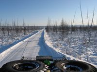
The winter_road=yes should be set on highways that are ![]() winter roads, seasonal roads on land in the arctic region which are functional only during winter and usually impassable in summer. The highway=* may also be present on the way, and its value should reflect the importance of the given highway in the network.
winter roads, seasonal roads on land in the arctic region which are functional only during winter and usually impassable in summer. The highway=* may also be present on the way, and its value should reflect the importance of the given highway in the network.
Large river crossings and those parts of winter roads that run upon water basins, should be tagged as ice_road=yes instead.
Mapping winter roads
In most cases the data source for mapping a winter road is a GPS trace. Rarely, if road runs through a wood cutline, satellite imagery can be used to trace winter roads.
Mapping sections that are passable in summer
Sometimes certain sections of a winter road are also used in summer. Please, don't overwrite the highway=* tag to the highway=track value on these sections. If you want to display that this section can be driven in summer, better remove the winter_road=yes tag and put the surface=dirt/sand/etc on it.
Mapping sections that differ from year to year
Usually, in the tundra some sections of winter roads vary from year to year. The new road may be laid up to several kilometers away from the previous one. The reason for such variations can be intentional, if previous seasons experience shows that some sections are not optimal, either containing too steep slopes, or suffering severely from blizzards, forming deep snow drifts. Also, variations can be unintentional, just because of the lack of GPS equipment in vehicles that service the road.
The suggested practice to map such variations is the following. Once a new GPS trace is uploaded, it should be traced from the beginning to the destination, seeking for places where it went off the mapped road. In these places new ways should be mapped, and highway=* + winter_road=yes put on them. It is also suggested to put the winter_road:year=* tag, that marks the year when the trace was recorded. If a trace was recorded in November or December, the year should be increased by one.
The older path should have the highway=* cleared, for example transformed to was:highway=*. So this way would disappear from rendered maps. The winter_road=yes and winter_road:year=* tags, if present, should be left untouched.
Mapping on water
Large river crossings and those parts of winter roads that run upon water basins, should be tagged as ice_road=yes instead.
See also
- ice_road=yes
- For more information on winter roads, please see the Proposed_features/Winter_roads and its discussion page.
- proposal "trafficability" (see discussion page)
