Ko:Tag:cemetery=grave
Jump to navigation
Jump to search
이 문서는 번역본이지만 번역이 완전하지 않고 빠지거나 잘못 되거나 아직 번역되지 않은 부분이 있습니다.
영어 원본의 내용을 이해할 수 있다면 번역 완료에 힘을 모아 주십시오. 번역 방법에 대해서는 위키 번역 방법에 대한 설명을 읽어주시길 바랍니다. 만약 이 문서의 번역이 충분하다고 판단되면 이 틀을 지워주시길 바랍니다.
이 즈음에는 맡아서 번역을 하는 사람이 없기 때문에, 당신이 이 작업을 해 줄 수 있습니다.
영어 원본의 내용을 이해할 수 있다면 번역 완료에 힘을 모아 주십시오. 번역 방법에 대해서는 위키 번역 방법에 대한 설명을 읽어주시길 바랍니다. 만약 이 문서의 번역이 충분하다고 판단되면 이 틀을 지워주시길 바랍니다.
이 즈음에는 맡아서 번역을 하는 사람이 없기 때문에, 당신이 이 작업을 해 줄 수 있습니다.
| 설명 |
|---|
| 주검을 묻으려 땅을 파서 만든 장소. 때로는 비석 같은 표지일 수도 있습니다. |
| 그룹: 토지 이용 |
| 해당 요소의 사용 |
| 의존하는 태그 |
|
| 유용한 조합 |
| 상태:사실상 표준 |
| 이 태그를 위한 도구 |
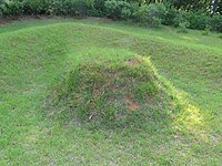
무덤은 주검을 묻으려 땅을 파서 만든 장소로, 봉분이나 석판일 수 있으며 때로는 비석으로 표시되어 있을 수도 있습니다.
무덤이 있는 곳이나 비문의 내용이 개인정보로 간주되는 지역[1]에서는 중요하거나 주목할 만한 무덤만 매핑하십시오.
매핑 방법
Place a node ![]() in the middle of the grave or map the outline
in the middle of the grave or map the outline ![]() of the grave.
of the grave.
Add cemetery=grave and name=* (adding the name of the deceased in the name=* tag is common practice)
inscription=* is a standard tag for recording text written on an object.
Add additional details in a description=* tag.
엮어서 쓸 수 있는 태그
- name=*
- wikipedia=*, wikidata=* – link to the Wikipedia article or Wikidata item about the grave itself
- subject:wikidata=* or buried:wikidata=* – link to the Wikidata item about the buried person(s) - both are in use.
Note that there can be a case where grave of someone is former or symbolic and buried:wikidata=* does not apply.
See also
- historic=tomb - 역사유적으로써의 무덤. 보기: 독무덤[옹관묘], 움무덤[토광묘], 석관묘, 고인돌, 피라미드 등 고분. 'cemetery=grave'는 주검을 묻으려 땅을 파서 만든 장소인 반면, historic=tomb은 건축된 구조물입니다.
- landuse=cemetery - 묘역
- amenity=grave_yard - 종교 시설에 딸린 묘터[묘지]. 여느 무덤이 모여있는 장소에는 쓰지 마십시오.
- 개인정보 매핑 제한 (graves were listed as example as non-mappable and removed after discussion on talk page)
Maps
- Open Burial Map: The "OSM buried:wikidata" source displays graves with buried:wikidata=*
References
- ↑ 나라나 지역마다 상황이 다르기 때문에, 예를 들어 사망자에 대한 정보에 GDPR 규정이 적용될 수도 있고 적용되지 않을 수도 있는 방법을 참조하세요.
