Lane assist/Examples/Motorway exit
Jump to navigation
Jump to search
Location on the map.
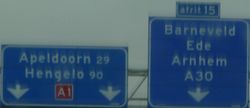
Lane assist example: standard motorway_exit tagging.
Part 1
- Ordinary motorway with two lanes.
highway=motorway
int_ref=E 30
lanes=2
maxspeed=120
oneway=yes
ref=A1
Part 2 This is the deceleration lane, which starts as shown in the example. Compared to part 1 the lanes count increases to 3 and one extra tag (turn:lanes) is used for the direction of the lanes based upon the arrows on the motorway.
highway=motorway
int_ref=E 30
lanes=3
maxspeed=120
oneway=yes
ref=A1
turn:lanes=none|none|slight_right
- The name and reference number of the exit is given on a signpost. At the end of the deceleration lane, the OSM-way of the motorway is split (highway=motorway_junction) and the new OSM-way of the slip road starts. Place the node of the motorway_junction as shown in the example, a little bit before the so-called restricted zone (the white painted area).
 highway=motorway_junction
ref=15
Part 3
- The OSM way of the motorway continues. The signpost above the motorway indicates that the road ahead is referred to as A1 and is leading to Apeldoorn and Hengelo. The tags destination and destination:ref are only used on the first OSM way directly after the motorway_junction.
destination=Apeldoorn;Hengelo
destination:ref=A1
highway=motorway
int_ref=E 30
lanes=2
maxspeed=120
oneway=yes
ref=A1
- The OSM way of the slip road. The signpost above the motorway indicates that the road ahead is referred to as A30 and is leading to Barneveld, Ede and Arnhem.
junction:ref=15
destination=Barneveld;Ede;Arnhem
destination:ref=A30
highway=motorway_link
maxspeed=120
oneway=yes
lanes=1
ref=A1
Note:
whenever possible, try to use destination:ref=* when destination=* is used.

