Livingston
| V・T・E |
| latitude: 55.8834, longitude: -3.5157 |
| Browse map of Livingston, Scotland 55°53′00.24″ N, 3°30′56.52″ W |
| Edit map |
|
External links:
|
| Use this template for your locality |
Livingston, Scotland is a town in Scotland at latitude 55°53′00.24″ North, longitude 3°30′56.52″ West.
Welcome
Welcome to the Livingston Project page. We are a group of volunteers in the Livingston area of Scotland that enjoy getting out and about and exploring, we then map the area using GPS Devices. Our volunteers come from every age and occupation so please be free to join in.
Mapping group, 10 Oct 2015
A small mapping party (limited by the size of the venue so wasn't added to the event calendar) was held at the Forestbank Community Centre. The following notes were created during discussions:
Pavement mapping
Pavements (as part of a road) are rare in Livingston. We think that mapping these is important. We think that any footway separated from the road, even if only by a grass strip, should be mapped as a separate footway (with its own line), but where the pavement is effectively a direct part of the road (with a kerb only separating these) it should be recorded as a 'sidewalk' in with the tagging for the road itself.
- The following 'Overpass Turbo' link will display a map of the roads tagged with 'sidewalk'. A coloured line indicates that sidewalk details have been added. The colour varies according to the detail. Here is a different version of the same thing.
- This paths and footways map (maintained for a temporary period by mapper 'Rostranimin') attempts to show mapped sidewalks in Livingston on a map designed to show footways. Footways on the map are automatically updated quickly. The sidewalk data has to be manually imported to the map so please let 'Rostranimin' know if you have made edits you'd like to see displayed. (Note that a double click on the map zooms it - and the same with the shift key zooms out. Also note that the map design will be improved if possible.)
- The JOSM editor has a 'map paint style' designed for displaying 'sidewalk' data which is particularly helpful during editing in Livingston.
The Mapillary service has many of the main roads shown on it and is useful for sidewalk mapping.
Pavements at roundabouts
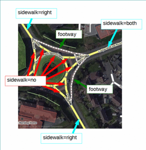
Pavement mapping at Livingston's main roundabouts can be complex. The main roads entering the roundabout may need to be tagged with 'sidewalk' details, but these roads often split at the roundabout entrance, and crossing arrangements become complex. One way to deal with this situation is recorded in the image shown (click to enlarge).
Local Cycle Network - tidying tagging
The Local Cycle Network is unclear in Livingston. Residents widely recognise some key shared-use paths as part of a local cycle network. These main paths through the town are signed with a small number of blue bicycle signs and are named (name=*). Some of these main paths have been added as relations (and the intention is that all the currently signed routes are added in this way).
There have also, in the past, been some reference numbers on relations based on the Core Path reference number. The Core path reference isn't signposted on the ground and core paths are not strictly LCN routes. Past addition of the core path details on OSM has conflated LCN with Core Path. See the West Lothian website for details. It is unclear if the core path network is available as open data and free to add to OSM as it is based on Ordnance Survey copyrighted maps.
Following this discussion with the original editor of the these relations, it is proposed we use Key:unsigned_ref tag to add the core path reference. This reference will not be rendered (on normal mapping).
Furthermore, a number of paths around Livingston have been tagged Local Cycle Network (LCN=yes) but are not signposted on the ground nor part of named paths. All LCN=yes were removed from ways without name=* tags as agreed with local mappers at the mapping party on 10 Oct 2015.
Footways and Bicycle access
Following discussion, the mapping party decided that highway=footway was appropriate in Livingston for the smaller, narrow paths within Livingston which are not specifically designed for bicycles (these are common). All highway=footway will be tagged bicycle=yes unless specifically signposted 'no cycling' on the ground (it is said to be the case that Livingston paths were always authorised for bicycle use).
Signed Route Network - re-survey
'Rostranimin') has (Nov2015) re-surveyed the whole of the Waverley Path, Bankton Mains Path, Newfarm Path, and Alderston Road path - ensuring they are mapped correctly with route relations. Others still require a re-survey - many errors existed. Note that these should be surveyed for existing signage, not for where the routes theoretically exist. The routes which may be signed include:
- Alderstone Path - full survey / corrected Nov 2015
- Almond Path
- Bankton Mains Path - full survey / corrected Nov 2015
- Burnside Path
- Folly Burn Path
- Grange Path
- Harrysmuir Path
- Hospital Path - survey June 2016 (Hobgoblin)
- Loan Path
- Murieston Path
- Nell Burn Path - survey July 2016 (Hobgoblin)
- Newfarm Path - full survey / corrected Nov 2015
- Peel Path - survey June 2016 (Hobgoblin)
- Railway Path
- Waverley Path - full survey / corrected Nov 2015
Social Events
We plan to have a meeting of people that are interested in a pub sometime in the future. See Scotland#Social_Meetings for other meetings in Scotland
Tools
- Keepright is a page dedicated to the small mapping errors that always crop up. Looking over this not only helps keep the map clean of these errors but helps us learn how to avoid errors in the future.
- If you are unsure about a name of a particular street the people that are in charge of this is West Lothian Council. They are the people that supply the information to Ordnance Survey but is more up to date, accurate and free for the Livingston Area. Their website is here
- If you want to see an overview of who is doing which edits in your area have a look at OSM Mapper watch the videos here
- Learning to edit this wiki or Wikipedia is a very useful skill. It well worth spending 20 minutes on this Tutorial
- The superb Map library in Edinburgh is well worth a visit Location. There are not many maps as yet for Livingston because it is such a new town. However there are a few of the surrounding towns. To see a huge selection of their maps go here and type in the name of the town you are looking for into the search box
- You can keep up to date by visiting the Opengeodata Blog, there is also an RSS feed for this
Cycle Routes
- "In 1987 legislation was passed to enable the footpaths in Livingston New Town to be used for cycling except at identified footbridges where cycling is prohibited for safety reasons. Source; Leaflet entitled Cycle Routes In Livingston published in 1988 by Lothian Regional Council." (see Civic Centre Bike User Group page). This exact phrase also appears on a map entitled "Livingston for Cyclists" (1998, Harvey Map Services Ltd, 'compiled from photogrammetric and... ...information supplied by West Lothian Council'). "In 1987 legislation was passed to enable the footpaths in Livingston New Town to be used for cycling except at identified footbridges where cycling is prohibited for safety reasons. The network includes footpaths away from roads which are well signposted, and traditional footways along the sides of roads."
- Footpaths in Livingston should therefore be marked either as highway=cycleway or as bicycle=yes.
- There was a volunteer cycle route surveying project run by West Lothian Council (see here). Perhaps the results could be obtained from the Council's cycling officer.
Other Maps
The Openstreetmap community is not allowed to copy other maps due to copyright restrictions. You will also find that a lot of the satellite images are out of date and that our map is already more accurate . The maps below are only here to show what other groups are doing.
- West Lothian Council have released Paths and rights of way information. These are very detailed maps of Livingston and are covered by Crown copyright, so we cannot copy them. We can use them to explore the area around and use our GPS to make our map. Start with DCPP 6 – Plan 5 Detailed Map Index. This will give you and idea which area you would like then download the Pdf at the bottom of the page.
- Livingston for Cyclists map, published by Harvey Maps, 1998.
- Spokes West Lothian map, published by Spokes, 2005.
- If you go to the wikipedia site for Livingston look for the part that says Coordinates Lat 55.8834 Lon -3.5157 W. Click on the link and you will get a list of maps for our area. You can do this for any location. See Livingston, Scotland and maps
- ELGIN Electronic Local Government Information Network Livingston
- Comparative maps can be interesting, you will also notice that Google satelite images are out of date see here and here
- Even more Other_maps
Examples and Inspiration
In this section there are examples of mapping and derived maps for your interest and inspiration. Please remember that it is very important that we do not copy other maps data into our map.
- The Best of OSM is a website that shows some of the best mapping in OSM, maybe we can get parts of Livingston in there.
- On the main map page of OSM by clicking on the '+' sign on the top right hand corner you can get the map represented as Open Cycle Map or Osmarender
- 2008 A year of Edits Is a video showing the progress of Openstreetmap throughout the world
- Interested in seeing the map in different styles see Cloudmade
- Lots of videos from State of the Map 2009 Highlighting Mapping of Historical Sites in Japan - Kinya Inoue and 20 Things You Never Knew About Potlach
- Vector graphics in the future see cartagen
- Scottish Openstreetmap in Gaelic here


