Mansfield Mapping Event 2009
Mansfield was identified as being a mapping priority in early 2009. A mapping weeking/party thing should help to improve the situation.
CANCELLED
THIS EVENT IS CANCELLED - James has the flu (nothing too serious we hope), and Matthew has had a bit of a roller coaster month or two and can't make it. Sorry all who were interested
Is this event likely to happen now it's a bit sunnier in 2010, or should the page be removed? If it's happening, then there's a few folks in Chesterfield who may be able to help. Thanks - Simon
When
TBA: Late July 2009?
A good provisional date is 25th-26th of July, in order to avoid overlapping with the State of the Map.
Where
Mansfield, Nottinghamshire, UK.
Meetup Location
- The Court House on the Market Square next to the Town Hall. Within five minutes' walk of the train station. "Pay later" parking available in the Four Seasons car park or Pay and Display parking on Quaker Way. Free wi-fi and food available. Location: 53.143986N 1.1969991W
What
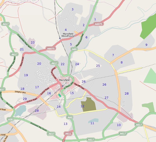
Mansfield has large areas which are sparsely mapped. Lets try to get as much of the road network as possible, and make a start on amenities and so on.
Higher res version available here.
| Slice # | Who | Time | Notes |
| 1 | |||
| 2 | |||
| 3 | |||
| 4 | |||
| 5 | |||
| 6 | |||
| 7 | |||
| 8 | |||
| 9 | |||
| 10 | |||
| 11 | Large slice | ||
| 12 | Large slice | ||
| 13 | |||
| 14 | |||
| 15 | |||
| 16 | |||
| 17 | |||
| 18 | |||
| 19 | |||
| 20 | |||
| 21 | |||
| 22 | |||
| 23 | |||
| 24 | |||
| 25 | Large slice | ||
| 26 | Large slice | ||
| 27 | Large slice | ||
| 28 | Large slice |
Who's Coming
- Matthew Gates
- James Tait
- Tom Reavey (Saturday morning and Sunday)
- (add yourself by adding a line containing *~~~ )
Organiser Contact
- Matthew Gates
- email: matthewg42 -at- gmail *dot* com
- IRC: matthewg42 @ OFTC (#osm channel)
- 07784367301
