| MapStalt Mini
|
|
|
| Author:
|
Microsoft
|
| License:
|
Proprietary (free as in beer)
|
| Platform:
|
Windows Phone
|
| Status:
|
Broken
|
| Version:
|
1.0.0.0 (2011-08-01)
|
| Language:
|
English
|
| Install:
|
|
| Programming language:
|
C#(?)
|
|
"MapStalt puts to power to complete the map into the hands of the mobile user" (grammar by Microsoft)
|
|
Features
| Feature
|
Value
|
| Map Display
|
| Display map
|
no
|
| Map data
|
POI(?)
|
| Source
|
online;cache;
|
| Rotate map
|
?
|
| 3D view
|
?
|
| Shows website
|
?
|
| Shows phone number
|
?
|
| Shows operation hours
|
?
|
| Routing
|
| Routing
|
no
|
| Create route manually
|
?
|
| Calculate route
|
?
|
| Create route via Waypoints
|
?
|
| Routing profiles
|
?
|
| Turn restrictions
|
?
|
| Calculate route without Internet (Offline routing)
|
?
|
| Routing providers
|
?
|
| Avoid traffic
|
?
|
| Traffic Provider
|
?
|
| Navigating
|
| Navigate
|
no
|
| Find location
|
?
|
| Find nearby POIs
|
?
|
| Navigate to point
|
?
|
| Navigation with voice / Voice guidance
|
?
|
| Keep on road
|
?
|
| Lane guidance
|
?
|
| Works without GPS
|
?
|
| Navigate along predefined route
|
?
|
| Tracking
|
| Make track
|
?
|
| Customizable log interval
|
?
|
| Track formats
|
?
|
| Geotagging
|
?
|
| Fast POI buttons
|
?
|
| Upload GPX to OSM
|
no
|
| Monitoring
|
| Monitoring
|
?
|
| Show current track
|
?
|
| Open existing track
|
no
|
| Altitude diagram
|
no
|
| Show POD value
|
?
|
| Satellite view
|
?
|
| Show live NMEA data
|
?
|
| Show speed
|
no
|
| Send current position
|
?
|
| Editing
?
|
| Rendering
?
|
| Accessibility
|
| Accessibility support
|
?
|
| Complete non graphics text output
|
no
|
| Braille interface
|
no
|
| Exploration modus
|
no
|
| Public Transport mode
|
no
|
| Danger Warnings
|
no
|
| Screenreader
|
?
|
| Screenreader languages
|
?
|
|
|
Overview
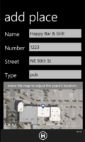
MapStalt Mini is a POI editor for Window Phone 7 that allows a user to add POIs and upload detailed information about a place directly to OpenStreetMap. It was released by Microsoft in August 2011.
Known bugs
- Puts a "create_by" tag (instead of created_by=*) on its changesets.
- Creates empty changesets (80 % of all changesets).
- Creates empty ("") changeset comments.
