Marikina Mapping Party/Announcement
What is a Mapping Party?
Mapping Parties are events where anyone can come and participate in the OpenStreetMap project. OpenStreetMap is a free and open source map that can be contributed, edited and used by anyone anywhere. Mapping Parties are social events where experienced and new mappers can meet to share and learn more about the project. The events are generally held in a public place, and allow time for discussions, mapping and editing.
The event is open to all. Are you a newbie interested in OpenStreetMapping? We will help you get started right away. Are you a business owner who wants a map showing your business location? We can help get your business location in the map. Are you a Garmin GPS owner who wants a routable map in your device? We will load our map in your device.
It's fun. It's free. You can help.
Schedule of activities
The event will start at 9:00 am at the Blue Wave Mall and will continue until the night. This event will push through rain or shine. (But given that it is El Niño season, it will likely be sunny.) If you're not interested in the actual mapping activity but would like to meet fellow mapping or GPS enthusiasts, then you should attend the socials in the evening.
| Time | Venue | Activity |
|---|---|---|
| 9:00 am - 10:00 am | Jollibee, Blue Wave Mall | Assembly and briefing |
| 10:00 am - 2:00 pm | All over Marikina | Field mapping (POI colletion) |
| 2:00 pm - 5:00 pm | SM City Marikina (exact place TBA) | Data editing and tutorials (free Wi-Fi!) |
| 5:00 pm onwards | TBA | Socials |
What will we map?
General objectives
- Create the best map of Marikina City that anyone can use and enjoy :-)
- Most roads in the city are already mapped, but some need verification for street names and footways.
- Add more points-of-interest to the city map as well as tackle areas that still need mapping.
- Focus on places like good eats, theme parks, museums, heritage places, historical places, trade hubs, and specialty crafts. Ed of WaypointsDotPH has volunteered to lead this effort.
Cake Slices
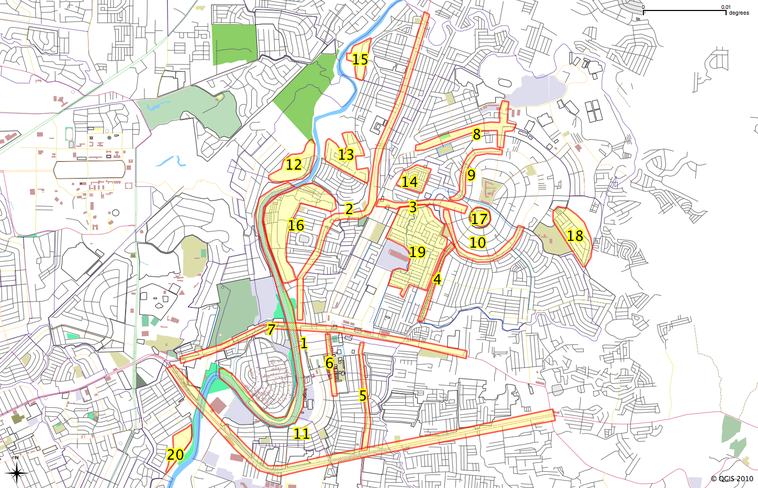
Cake slicing is a phrase used in OpenStreetMap Mapping Parties where the area to be mapped (the cake) gets divided into smaller areas (the slices) such that each slice can be surveyed and mapped by around one to three people. It's basically your simple divide-and-conquer approach to mapping! The assignment of which cake slices will be surveyed by which people will be done during the briefing at 9:00am.
The planned cake slices are shown on the map below and listed in the table after.
| Slice Code | Priorities | Link to the existing map | Assigned people |
|---|---|---|---|
| 1 | POIs, amenities (picnic tables, playgrounds) along Marikina River Park | http://www.openstreetmap.org/?way=25175881 | |
| 2 | POIs along JP Rizal (from Sto Nino to Nangka) | http://www.openstreetmap.org/?way=4910297 | |
| 3 | POIs Bayan-bayanan Avenue | http://www.openstreetmap.org/?way=4357062 | |
| 4 | POIs along Katipunan Road | http://www.openstreetmap.org/?way=30704804 | |
| 5 | POIs along Gil Fernando | http://www.openstreetmap.org/?way=4603203 | |
| 6 | POIs along Shoe Avenue | http://www.openstreetmap.org/?way=4357058 | |
| 7 | POIs along Don Juan Sumulong and Bonifacio Avenue | http://osm.org/go/4zhToHLrg-- | |
| 8 | POIs along Gen B. G Molina | http://www.openstreetmap.org/?way=4893513 | |
| 9 | POIs along General Ordonez (Parang) | http://osm.org/go/4zhZFRUCs- | |
| 10 | POIs along General Ordonez (Marikina Heights) | http://www.openstreetmap.org/?way=4603220 | |
| 11 | POIs along Marcos Highway | http://osm.org/go/4zhS5MQ5 | |
| 12 | new housing development | http://osm.org/go/4zhTtW@s8- | |
| 13 | new roads and name verification, footways and others POIs in Tumana | http://osm.org/go/4zhT4uHB5- | |
| 14 | add road names, cannot access without sticker or permit | http://osm.org/go/4zhTvyTvs- | |
| 15 | footways and road names | http://osm.org/go/4zhT8uL1Z- | |
| 16 | footways, road, and names verification Footways in Malanday | http://osm.org/go/4zhTsRVW6- | |
| 17 | road names and amenity details | http://osm.org/go/4zhZEWs1T-- | |
| 18 | verify road names | http://osm.org/go/4zhZGPVzX- | |
| 19 | verify road names | http://osm.org/go/4zhTukx62- | |
| 20 | add footways and roads in Industrial Valley | ||
Note: Most of the slices are small and can be mapped in 2 hours or less, experienced mappers can take on 2 or 3 slices.
Other suggestions
For those who cannot join the field mapping, you can participate by doing armchair mapping, like:
- Cleaning openstreetbug and keepright reports
- Add landuse and building polygon
- Clean-up maning's Marikina checklist
Who will attend
If you own a GPS or laptop computer, please bring it along. If not, we will have GPS units to loan.
You can also signify your attendance over at Facebook.
Main contact person
- Maning Sambale: emmanuel.sambale@gmail.com

