Mobile Trail Explorer
| Mobile Trail Explorer | ||||||||||||||||||||||||||||||||||||||||||||||||||||||||||||||||||||||||||||||||||||||||||||||||||||||||
|---|---|---|---|---|---|---|---|---|---|---|---|---|---|---|---|---|---|---|---|---|---|---|---|---|---|---|---|---|---|---|---|---|---|---|---|---|---|---|---|---|---|---|---|---|---|---|---|---|---|---|---|---|---|---|---|---|---|---|---|---|---|---|---|---|---|---|---|---|---|---|---|---|---|---|---|---|---|---|---|---|---|---|---|---|---|---|---|---|---|---|---|---|---|---|---|---|---|---|---|---|---|---|---|---|
| Author: | Tommi Laukkanen | |||||||||||||||||||||||||||||||||||||||||||||||||||||||||||||||||||||||||||||||||||||||||||||||||||||||
| License: | GNU GPL | |||||||||||||||||||||||||||||||||||||||||||||||||||||||||||||||||||||||||||||||||||||||||||||||||||||||
| Platform: | Java ME | |||||||||||||||||||||||||||||||||||||||||||||||||||||||||||||||||||||||||||||||||||||||||||||||||||||||
| Version: | 1.14 (2009-03-24) | |||||||||||||||||||||||||||||||||||||||||||||||||||||||||||||||||||||||||||||||||||||||||||||||||||||||
| Language: | 5
| |||||||||||||||||||||||||||||||||||||||||||||||||||||||||||||||||||||||||||||||||||||||||||||||||||||||
| Website: | http://code.google.com/p/mobile-trail-explorer/ | |||||||||||||||||||||||||||||||||||||||||||||||||||||||||||||||||||||||||||||||||||||||||||||||||||||||
| Source code: | http://mobile-trail-explorer.googlecode.com/svn/trunk/ | |||||||||||||||||||||||||||||||||||||||||||||||||||||||||||||||||||||||||||||||||||||||||||||||||||||||
| Programming language: | Java | |||||||||||||||||||||||||||||||||||||||||||||||||||||||||||||||||||||||||||||||||||||||||||||||||||||||
| ||||||||||||||||||||||||||||||||||||||||||||||||||||||||||||||||||||||||||||||||||||||||||||||||||||||||
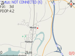
Mobile Trail Explorer is an application where user can view and record tracks using the mobile phone and GPS device (either external or internal). Recorded tracks can be exported in KML or GPX formats so that they can be viewed in Google Earth application. See further MTE Documentation.
Selling Points
- Free & open source software.
- Loads Open Street Map (as well a few other providers') data from the web or a previously cached session.
- Records tracks and save them to GPX format (this is the main format JOSM and Open Street Map support.) The interface is simple enough that you can easily record and save multiple tracks to custom file names when you're on the go.
- Records and export waypoints in GPX format. By default you can set a waypoint by pressing the pound (#) key. There is an additional menu that allows you to create and name waypoints, as well as assign metadata.
- Voice waypoint recording
- SMS your location to another phone.
- Has a dead simple interface for navigating through
- Map view
- Elevation graph
- Altitude/heading/speed/misc data, targeted at bike & bushwalking enthusiasts.
- Waypoints
- Satellite availability & strength
- Sky view — a graphical representation of the previous screen mapped on a sphere.
- Speedometer
Loading Maps
Open Street Maps can be loaded onto Trail Explorer via a tool called CacheCreator. CacheCreator takes a directory of cached tiles in the /%d/%d/%d.png format and converts them into the format Trail Explorer needs to run.
This process uses the command line, so it's expected you're familiar with the basic command line functionality of your operating system. The directions on the CacheCreator page are reasonably straightforward.
Note that you should only include limited number of tiles, because Trail Explorer doesn't handle large amounts of tile data well. You may be able to load more, but testing with Nokia 6120 shows you should generally keep the map size under 3 megabytes.
Open Street Map Use
This is a very useful piece of software for contributing to Open Street map. The track recording is simple enough you could potentially record a single track for each road/path on foot. The waypoint functionality is simple enough that you could tag items on the run, and fill in the metadata later.
While the map size limitation is frustrating, this is easily one of the more appropriate mapping applications for less powerful handsets.
