New Zealand/Missing Streets
| New Zealand Missing Streets | ||||||||||||||||||||||||||||||||||||||||||||||||||||||||||||||||||||||||||||||
|---|---|---|---|---|---|---|---|---|---|---|---|---|---|---|---|---|---|---|---|---|---|---|---|---|---|---|---|---|---|---|---|---|---|---|---|---|---|---|---|---|---|---|---|---|---|---|---|---|---|---|---|---|---|---|---|---|---|---|---|---|---|---|---|---|---|---|---|---|---|---|---|---|---|---|---|---|---|---|
| Author: | Kylenz | |||||||||||||||||||||||||||||||||||||||||||||||||||||||||||||||||||||||||||||
| License: | MIT License | |||||||||||||||||||||||||||||||||||||||||||||||||||||||||||||||||||||||||||||
| Platform: | Web | |||||||||||||||||||||||||||||||||||||||||||||||||||||||||||||||||||||||||||||
| Status: | Active | |||||||||||||||||||||||||||||||||||||||||||||||||||||||||||||||||||||||||||||
| Version: | 2.0.0 (2024-02-18) | |||||||||||||||||||||||||||||||||||||||||||||||||||||||||||||||||||||||||||||
| Language: | English
| |||||||||||||||||||||||||||||||||||||||||||||||||||||||||||||||||||||||||||||
| Website: | https://osm-nz.github.io/missing-streets | |||||||||||||||||||||||||||||||||||||||||||||||||||||||||||||||||||||||||||||
| Source code: | osm-nz/missing-streets GitHub | |||||||||||||||||||||||||||||||||||||||||||||||||||||||||||||||||||||||||||||
| Programming language: | TypeScript | |||||||||||||||||||||||||||||||||||||||||||||||||||||||||||||||||||||||||||||
|
Identifies street names that are missing in OpenStreetMap, using data from LINZ. |
||||||||||||||||||||||||||||||||||||||||||||||||||||||||||||||||||||||||||||||
| ||||||||||||||||||||||||||||||||||||||||||||||||||||||||||||||||||||||||||||||
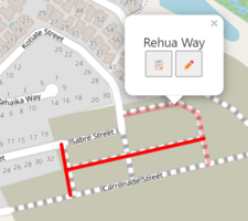
The 'Missing Streets' tool allows you quickly find and fix missing street names in New Zealand. This is based on the NZ Roads dataset from LINZ.
The editor allows you to make simple edits, for example, fixing a typo in a road name. For more complex edits, a button takes you straight to the iD editor.
How to use it
Visit the tool, and find a street that you want to add or fix.
Adding new streets
There are some streets that the tool suggests which do not exist yet. Use highway=construction or highway=proposed for these roads.
There are also cases where the street no longer exists or never existed (e.g. ![]() Paper roads).
In most cases these roads should be ignored.
Paper roads).
In most cases these roads should be ignored.
Updating names
In some cases the street is already mapped, but the name is incorrect.
You can either:
- replace the current name=* tag
- or add the suggested name to a tag like alt_name=*, old_name=*, official_name=*, or not:name=* (if the suggestion is incorrect)
Code & Data
The code for the tool is available from osm-nz/missing-streets GitHub. The data comes from LINZ's Roads dataset, which is updated weekly.
How it works
The tool extracts every highway=* feature in New Zealand from the OpenStreetMap Planet, and compares them with the dataset from LINZ. Names that are completely missing in OSM are shown in the tool. This process takes about 5 minutes.
This script automatically runs on Wednesday morning (NZ time), and uploads the result to the ![]() CDN. The website fetches the latest data from that CDN.
CDN. The website fetches the latest data from that CDN.
