North East India
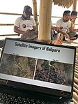
OpenStreetMap North East India was formed to coordinate and organize more local events in the northeastern states of India. The north-eastern state of India comprises of Arunachal Pradesh, Assam, Manipur, Meghalaya, Mizoram, Nagaland, Sikkim and Tripura commonly known as North East India. These regions are least mapped and often disconnected in reality. As a solution to this through community mapping OpenStreetMap North East India community was formed on 16th January 2023 in Baligaon village, Sonitpur, Assam. A workshop was conducted in association with Open Mapping Hub Asia Pacific and Balipara Foundation to educate the students and the members of the local community on how to use OpenStreetMap to create and update accurate, freely editable, and sharable maps of the North East region as the first program of OSM North East India community.
Past Events
OSM North East India Mapathon
- Date: 19/08/2023
- Location: Online mode
- Description: Disaster Mapathon: Digitizing roads and buildings in flood affected India.
Introductory workshop on OpenStreetMap
- Date: 16/01/2023
- Location: Sonitpur, Assam
- Description: Workshop on OSM for students and indigenous community.
Collaboration
GRED FOUNDATION
- Description: GREd Foundation is a GIS training institute in the Northeast India.


