Nottingham/Mapping Meetup

Next Meeting: 2019 New Year meeting
See details on separate page: Nottingham/Mapping Meetup/New Year 2019
Location: Lees, Derbyshire. Date: tbd.
2018 New Year Meeting : Saturday 30th December 2017
Meet at Blackhorse, Coton-in-the-Elms at 10:30 (mapping) or between 12:30 and 13:00 (social & lunch) at , Rosliston.
Event Details
The New Year mapping meeting will be in the same format of the initial meeting, and again will be focussed on mapping footpaths and other rights of way. A lunch time pub stop also gives other interested people a chance to join the group. This time we will be in South Derbyshire, S of Swadlincote, an area which is poorly mapped with the exceptions of areas of the National Forest.
The villages of Rosliston, Coton-in-the-Elms, Lullington and Southseal all lack detail. Most footpaths, with the exceptions of one long-distance path and trails in a couple of National Forest areas, are missing.
The countryside is mainly on Keuper Marl (Mercia Mudstones) with the NE edge of the area being more geologically complex. Farming is mainly arable so there's likely to be a fair amount of mud.
- Morning Meeting Point: Black Horse pub, Coton in the Elms
- Lunch & Afternoon Meeting Point: Bulls Head pub (5266821772
 5266821772)
The format is as follows, with 3 discrete activities which allows people to participate in 1 or 2 if they wish:
- 10:30: Meet for morning footpath session (either together or splitting up to maximise area covered)
- 12:30-13:00: Pub lunch (pub lunch, some walkers may arrive a bit after 12:30)
- 14:00-14:30: Further footpath or other mapping sessions.
Mapping Objectives
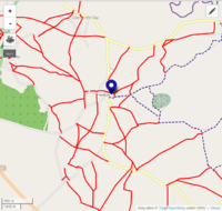
- Public Rights of Way. See this Umap instance to see what might be missing. There are several possible loops from both Coton-in-the-Elms and Rosliston, but also from nearby points.
- Villages. Plenty of detail missing in the villages mentioned.
- Better Photos, Mapillary sequences to assist interpretation of aerial imagery, maps for remote mapping of the area.
- Countryside detail, hedges , watercourses, woodland etc. Feel free to add detail before the event as it will be cross-checked on the ground.
Useful sources of Info
- Wikipedia accounts of villages: Coton in the Elms
![[W]](/w/images/2/24/Wikipedia-16px.png) Coton in the Elms, Rosliston
Coton in the Elms, Rosliston ![[W]](/w/images/2/24/Wikipedia-16px.png) Rosliston, Derbyshire
Rosliston, Derbyshire
14th January 2017, Scalford, Leicestershire
t.b.a.
5th March 2016, Consall Forge / Ipstones
Meet at Old Red Lion, Ipstones at 10:30 (mapping) or between 12:30 and 13:00 (social & lunch) at Black Lion Consall Forge.
Note - there are many duplicately named "lion" pubs of various hues in this area. Make sure you go to the right ones!
Event Details
The next mapping meet will follow the existing formula, and again will be focussed on mapping footpaths and other rights of way. A lunch time pub stop also gives other interested people a chance to join the group. This time we will be in Mid Staffordshire, and area which is poorly mapped with much added from old maps and aerial images.
- Morning Meeting Point: Ipstones
- Lunch & Afternoon Meeting Point: Black Lion pub (92205316
 92205316)
The format is as follows, with 3 discrete activities which allows people to participate in 1 or 2 if they wish:
- 10:30: Meet for morning footpath session (either together or splitting up to maximise area covered)
- 12:30-13:00: Pub lunch (pub lunch, some walkers may arrive a bit after 12:30)
- 14:00-14:30: Further footpath or other mapping sessions.
Mapping Objectives
- Public Rights of Way. See this Umap instance to see what might be missing. There are several possible loops from Abbots Bromley, but also from nearby points (some may be awkward for parking, the availability of more than one car means that these might be specifically useful targets).
- Villages. Plenty of detail missing in Abbots Bromley itsefl.
- Better Photos, Mapillary sequences to assist interpretation of aerial imagery, maps for remote mapping of the area.
Who Came
trigpoint,SomeoneElse,SK53,dudley,brianboru
What Got Mapped

Past Meeting: 30th December 2015, Abbots Bromley
Useful sources of Info
- Wikipedia accounts of villages: Abbots Bromley
![[W]](/w/images/2/24/Wikipedia-16px.png) Abbots Bromley== Last Meeting: 30th December 2015, Abbots Bromley ==
Abbots Bromley== Last Meeting: 30th December 2015, Abbots Bromley ==
Meet at Buttercross, Abbots Bromley at 10:30 (mapping) or between 12:30 and 13:00 (social & lunch) at Coach & Horses.
Event Details
The New Year mapping meeting will follow on from the successful format of the initial meeting, and again will be focussed on mapping footpaths and other rights of way. A lunch time pub stop also gives other interested people a chance to join the group. This time we will be in South Staffordshire, and area which is poorly mapped with much added from old maps and aerial images.
- Morning Meeting Point: Buttercross, Abbots Bromley
- Lunch & Afternoon Meeting Point: Coach & Horses pub (2078053609
 2078053609)
The format is as follows, with 3 discrete activities which allows people to participate in 1 or 2 if they wish:
- 10:30: Meet for morning footpath session (either together or splitting up to maximise area covered)
- 12:30-13:00: Pub lunch (pub lunch, some walkers may arrive a bit after 12:30)
- 14:00-14:30: Further footpath or other mapping sessions.
Mapping Objectives
- Public Rights of Way. See this Umap instance to see what might be missing. There are several possible loops from Abbots Bromley, but also from nearby points (some may be awkward for parking, the availability of more than one car means that these might be specifically useful targets).
- Villages. Plenty of detail missing in Abbots Bromley itsefl.
- Better Photos, Mapillary sequences to assist interpretation of aerial imagery, maps for remote mapping of the area.
Useful sources of Info
- Wikipedia accounts of villages: Abbots Bromley
![[W]](/w/images/2/24/Wikipedia-16px.png) Abbots Bromley
Abbots Bromley
Last Meeting: 14th March 2015, Gringley on the Hill
Meet at Blue Bell, Gringley-on-the-Hill at 10:30 (mapping) or between 12:30 and 13:00 (social & lunch).
Event Details
The second mapping meeting will follow on from the successful format of the first meeting, and again will be focussed on mapping footpaths and other rights of way. A lunch time pub stop also gives other interested people a chance to join the group. This time we will be in North Nottinghamshire, and area which is poorly mapped with much added from old maps and aerial images.
Meeting & Lunch Point: Blue Bell, Gringley-on-the-Hill. (not apparently on OSM at time of writing).
The format is as follows, with 3 discrete activities which allows people to participate in 1 or 2 if they wish:
- 10:30: Meet for morning footpath session (either together or splitting up to maximise area covered)
- 12:30-13:00: Pub lunch (pub lunch, some walkers may arrive a bit after 12:30)
- 14:00-14:30: Further footpath or other mapping sessions.
Mapping Objectives
- Public Rights of Way. See this Umap instance to see what might be missing. There are several possible loops from Gringley on the Hill, but also from nearby villages (e.g, from Everton to Everton Carr or between Everton & Mattersey.
- Villages. Plenty of detail missing in Everton, Gringley-on-the-Hill, Walkeringham etc.
- Better Photos, Mapillary sequences to assist interpretation of aerial imagery, maps for remote mapping of the area.
Useful sources of Info
- Wikipedia accounts of villages: Everton
![[W]](/w/images/2/24/Wikipedia-16px.png) Everton, Nottinghamshire, Walkeringham
Everton, Nottinghamshire, Walkeringham![[W]](/w/images/2/24/Wikipedia-16px.png) Walkeringham, Misterton
Walkeringham, Misterton ![[W]](/w/images/2/24/Wikipedia-16px.png) Misterton, Gringley on the Hill
Misterton, Gringley on the Hill ![[W]](/w/images/2/24/Wikipedia-16px.png) Gringley on the Hill
Gringley on the Hill - Mattersey was had a monastery (Mattersey Priory) 328043786
 328043786 of the only English indigenous monastic order, the [Gilbertine]s. On English Heritage website
 - The last (true) Princess of Wales is buried at Mattersey.
Who Came
Tom, Jerry and Andy spent the whole day mapping footpaths. Initially together and then splitting off before lunchtime to rendezvous at the pub. The morning concentrated on paths due S of Gringley-on-the-Hill. The afternoon was spent to the SE of Gringley-on-the-Hill walking together. [[User:SK53|Jerry] also did some mapping on Everton Carr before we met.
Things Mapped
1st Meeting : January 2015
The first of the Nottingham group's meetups specifically aimed at doing some mapping, organised as a joint event with Mappa Mercia.
Report on the day at Maps Matter blog
Event details
Cock Inn, Hanbury Hill, Staffordshire 77045831![]() 77045831. 3rd January 2015, start time 10:30.
77045831. 3rd January 2015, start time 10:30.
We have chosen the area around Hanbury and Draycott in the Clay which is to the west of Burton-on-Trent. There are a good number of completely unmapped footpaths between these two locations, and a number of pubs. Of particular interest is the Fauld Crater which can be reached from a path starting at the Cock Inn, Hanbury Hill.
Meet at 10:30 in the car park of the Cock Inn. Lifts may be available from Jerry (Derby, Nottingham area), and Rob (Coventry, Warwick), and we can arrange a pick-up from Burton Station too. We may be able to split up to maximise the number of these we can get in the time available. Aim is to return to the Cock between 12:30 and 13:00 for a drink and/or lunch.
Who came
Planning stated with a Doodle poll where 8 people indicated they could attend (see here). Since then Dudley has also indicated that he hopes to attend.
A total of 9 attended, with a hardy crew of 8 actually going out in the murk to look at the crater. We were joined by User:brianboru for lunch. After lunch some detail was mapped in the village of Hanbury and 3 separate parties covered further footpaths on the ground.
Mapping

Current plan is to start by doing a short walk as a group. We'll walk from the car park to Fauld crater chatting as we go. From there we can split into a few groups. Some current ideas include:
- Jerry: Roughly I plan a walk to look at the crater followed by mapping the footpaths between Hanbury & Draycott.
- Rob: I'll do a circular walk. Most likely will drive to Draycott and do the light blue dashed walk shown on the map. I am flexible if others want to do Draycott instead :-)
Some more ideas:
- Map the buildings and addresses in the village of Hanbury.
- Photograph and map the historic listed buildings (see link below).
- Get dropped of at Draycott in the Clay to map the village and walk back on the footpaths.
See also
- Wikipedia:Hanbury
- Nationally listed buildings, search for "Hanbury" and select "Hanbury, Staffs" from the results.
- Footpaths map
- Missing footpaths (in red)