OSM Buildings
(Redirected from OSMBuildings)
| OSM Buildings | ||||||||||||||||||||||||||||||||||||
|---|---|---|---|---|---|---|---|---|---|---|---|---|---|---|---|---|---|---|---|---|---|---|---|---|---|---|---|---|---|---|---|---|---|---|---|---|
| Author: | Jan Marsch | |||||||||||||||||||||||||||||||||||
| Status: | Unmaintained | |||||||||||||||||||||||||||||||||||
| Website: | https://osmbuildings.org/ | |||||||||||||||||||||||||||||||||||
| ||||||||||||||||||||||||||||||||||||


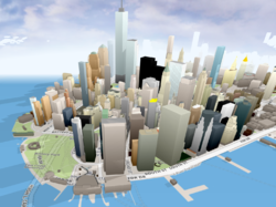
OSMBuildings is an engine for displaying 3D buildings on a web map.
You can download the javascript code to run this as an effect overlaid upon maps with OpenLayers or Leaflet. It uses HTML5 canvas, which will require a modern web browser.
License
Fronted code is a free software, while backend code is proprietary.
You can navigate by mouse, or using touch screen.
Development
Classic 2.5D version on github https://github.com/kekscom/osmbuildings
Modern WebGL version on github https://github.com/OSMBuildings/OSMBuildings. Not updated since 2020 after a name dispute
Created by Jan Marsch

![OSMBuildings [1]](/w/images/e/e3/Logo%2BText.small.png)