OSM Open
| OSM Open | ||||||||||||||||||||||||||||||||||||||||||||||||||||||||||||||||||||||||||||||||||||||||||||||||||||||||||||||||||||||||||||||||
|---|---|---|---|---|---|---|---|---|---|---|---|---|---|---|---|---|---|---|---|---|---|---|---|---|---|---|---|---|---|---|---|---|---|---|---|---|---|---|---|---|---|---|---|---|---|---|---|---|---|---|---|---|---|---|---|---|---|---|---|---|---|---|---|---|---|---|---|---|---|---|---|---|---|---|---|---|---|---|---|---|---|---|---|---|---|---|---|---|---|---|---|---|---|---|---|---|---|---|---|---|---|---|---|---|---|---|---|---|---|---|---|---|---|---|---|---|---|---|---|---|---|---|---|---|---|---|---|---|
| Author: | Hauke Stieler | |||||||||||||||||||||||||||||||||||||||||||||||||||||||||||||||||||||||||||||||||||||||||||||||||||||||||||||||||||||||||||||||
| License: | GNU GPL v3 | |||||||||||||||||||||||||||||||||||||||||||||||||||||||||||||||||||||||||||||||||||||||||||||||||||||||||||||||||||||||||||||||
| Platform: | Web | |||||||||||||||||||||||||||||||||||||||||||||||||||||||||||||||||||||||||||||||||||||||||||||||||||||||||||||||||||||||||||||||
| Version: | 1.2.0 releases (2025-02-08) | |||||||||||||||||||||||||||||||||||||||||||||||||||||||||||||||||||||||||||||||||||||||||||||||||||||||||||||||||||||||||||||||
| Language: | English
| |||||||||||||||||||||||||||||||||||||||||||||||||||||||||||||||||||||||||||||||||||||||||||||||||||||||||||||||||||||||||||||||
| Website: | https://hauke-stieler.de/osm-open/ | |||||||||||||||||||||||||||||||||||||||||||||||||||||||||||||||||||||||||||||||||||||||||||||||||||||||||||||||||||||||||||||||
| Source code: | https://github.com/hauke96/osm-open | |||||||||||||||||||||||||||||||||||||||||||||||||||||||||||||||||||||||||||||||||||||||||||||||||||||||||||||||||||||||||||||||
|
Web app to visualize and filter opening hours of POIs. |
||||||||||||||||||||||||||||||||||||||||||||||||||||||||||||||||||||||||||||||||||||||||||||||||||||||||||||||||||||||||||||||||
| ||||||||||||||||||||||||||||||||||||||||||||||||||||||||||||||||||||||||||||||||||||||||||||||||||||||||||||||||||||||||||||||||
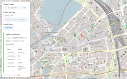
OSM Open is a simple web application to load POIs and visualize their opening hours.
Usage
General usage is as follows:
1. Zoom to the area you want to search in. 2. Select a point in time for which the opening hours should be checked. 3. Select a tag filter (either from the selection menu or manually type in an Overpass-like-expression) 4. Click on "Load data" to load all elements with opening hours. 5. Click on a point to get further information.
By clicking on a point, you see a link to the OSM-object, additional details and all tags of this object.
Colors on the map
Each POI on the map is a colored point with one of the following colors:
- Red: Is closed at the selected point in time.
- Green: Is open at the selected point in time.
- Gray: Matches the tag-filter, but has no opening hour data in OSM.
Filter expression
A filter expression has the operators = for simple equality matching and ~ for regular expressions using the same syntax Overpass uses.
The filtering is case-sensitive.
Examples:
- Just restaurants:
amenity=restaurant - Everything with a name containing "Burger" or "burger" (making it a case-insensitive query):
name~.*[bB]urger.* - Pubs and bars:
amenity~(pub|bar)
Technical details
- This app has no backend and simply uses Overpass-Turbo to get the data.
- All data within the map extent is queried that fulfills the given tag-filter.
Development
The code is on GitHub. Development documentation can be found there.
