Tasking Manager
| Tasking Manager | ||||||||||||||||||||
|---|---|---|---|---|---|---|---|---|---|---|---|---|---|---|---|---|---|---|---|---|
| License: | FreeBSD License | |||||||||||||||||||
| Status: | Active | |||||||||||||||||||
| Website: | https://github.com/hotosm/tasking-manager/ | |||||||||||||||||||
| Source code: | https://github.com/hotosm/tasking-manager/ | |||||||||||||||||||
| Programming languages: | JavaScript and Python | |||||||||||||||||||
|
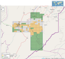
Tool for teams to coordinate mapping on OpenStreetMap. The screenshot shows a project progress overview of the Tasking Manager. |
||||||||||||||||||||
| ||||||||||||||||||||
The Tasking Manager is a tool for coordination of volunteers and organization of groups to map on OpenStreetMap. It was initially designed and built by and for the Humanitarian OSM Team (HOT), and is nowadays used by many other communities and organizations. The purpose of the tool is to divide up a mapping job into smaller tasks that can be completed rapidly. It shows which areas need to be mapped and which areas need the mapping validated. This approach facilitates the distribution of tasks to the various mappers. It also allows control of the progress and the homogeneity of the work done (i.e. elements to cover, specific tags to use, etc.).
You can see the tool in action: log into the widely used HOT Tasking Manager and start mapping. Check the HOT Tasking Manager Organizations page to see a list of organizations which are present on HOT's Tasking Manager.
For information on how to use the Tasking Manager please review the manuals on LearnOSM. When creating a project in the Tasking Manager, you may want to have a look on the default instructions for tagging roads, buildings, waterways.
The Tasking Manager is Free and Open Source Software and is continuously maintained and actively further developed by a community. The source code is on Github: https://github.com/hotosm/tasking-manager and inquiries, issues and bugs also managed there.
Operational installations of the Tasking Manager
Several Tasking Managers are no longer maintained and are crossed out below to indicate this:
- Projects worldwide:
- https://tasks.hotosm.org/ – for Humanitarian OSM Team (TM version 4)
- https://tasks.teachosm.org/ – for TeachOSM (TM version 4)
http://taches.francophonelibre.org/– TM version 2 (lighter and faster) run by Les Libres Géographes, currently focuses mostly on French-speaking Southern countries & the Erasmus+ project euYoutH_OSM but basically open to project creation by any contributor making the request - please send an email to contact @ leslibresgeographes.org for rights to project creation or any info)https://osm.earth – for OSM Earth- https://tasks.kaart.com/ – for Kaart (TM version 4)
- https://tasks.mapwith.ai/ - fork of TM4 used by the mapping teams at Meta. This instance also plans to build experimental integrations with MapWithAI data and services. Use of this TM is available to any OSM users. (TM version 4)
- https://tasks.opensidewalks.com/ - OpenSidewalks (TM version 4)
- Projects in the Americas:
http://tasks.osmcanada.ca/ – for OSM Canada (TM version 2)http://gt.osmqc.ca/ – for OSM Quebec- https://tasks.openstreetmap.us/ – for OSM US (TM version 4)
http://osmcolorado.com/ – for OSM Colorado (TM version 3)http://tareas.mapazonia.org/ – for Mapazonia (OSM Latam)http://tasks.atlasurbano.org - for Atlas Urbano PY (OSM Paraguay)- https://tareas.nomadas.org.pe/ - for OSM Peru (TM version 4)
- Projects in Europe:
https://tasks.osm-hr.org/ - for OSM Croatia (TM version 4)http://ijjarvin.kapsi.fi/osmtm – for OSM Finland- https://tm.osm.grin.hu/explore/ - for OSM Hungary (TM version 4)
- https://tasks.openstreetmap.ie/ – for OSM Ireland (TM version 4)
- https://osmit-tm4.wmcloud.org/ – for OSM Italy (operated by Wikimedia Italia, changesets are marked with #osmitaly) (TM version 4)
https://tarefas.openstreetmap.pt/ – for OSM Portugal- https://tareas.openstreetmap.es/ – for OSM Spain (TM version 4)
http://tasks2.openstreetmap.se/ – for OSM Sweden- https://tasks.osm.ch/ – public instance operated by SOSM (Switzerland) (TM version 4)
- https://tasks.euthmappers.com - for EUthmappers(TM version 4)
- Projects in Asia:
http://tasks.openstreetmap.in/ – for OSM India- https://mapmykerala.in/ - for OSM community in Kerala, India (TM version 4)
http://tasks.openstreetmap.id/ – for OSM Indonesiahttp://tasks.transcaucasiantrail.org/ – for TransCaucasianTrail
- Project(s) in Oceania
- https://tasks.smartcitiestransport.com/ - for Oceania (loosely affiliated with Maptime Oceania slack workspace - TM version 4)
- Other purposes:
- https://tasks.openhistoricalmap.org – for OpenHistoricalMap (TM version 4)
