Divide and map. Now.
| Divide and map. Now. | ||||||||||||||||||||||||||||||||||||||||||||||||||||||||||||||||||||||||||||||||||||||||||||||||||||||||||||||||||||||||
|---|---|---|---|---|---|---|---|---|---|---|---|---|---|---|---|---|---|---|---|---|---|---|---|---|---|---|---|---|---|---|---|---|---|---|---|---|---|---|---|---|---|---|---|---|---|---|---|---|---|---|---|---|---|---|---|---|---|---|---|---|---|---|---|---|---|---|---|---|---|---|---|---|---|---|---|---|---|---|---|---|---|---|---|---|---|---|---|---|---|---|---|---|---|---|---|---|---|---|---|---|---|---|---|---|---|---|---|---|---|---|---|---|---|---|---|---|---|---|---|---|
| Author: | qeef | |||||||||||||||||||||||||||||||||||||||||||||||||||||||||||||||||||||||||||||||||||||||||||||||||||||||||||||||||||||||
| License: | GNU AGPL (free of charge) | |||||||||||||||||||||||||||||||||||||||||||||||||||||||||||||||||||||||||||||||||||||||||||||||||||||||||||||||||||||||
| Platform: | Web | |||||||||||||||||||||||||||||||||||||||||||||||||||||||||||||||||||||||||||||||||||||||||||||||||||||||||||||||||||||||
| Status: | Active | |||||||||||||||||||||||||||||||||||||||||||||||||||||||||||||||||||||||||||||||||||||||||||||||||||||||||||||||||||||||
| Version: | https://git.sr.ht/~qeef/damn-deploy/refs | |||||||||||||||||||||||||||||||||||||||||||||||||||||||||||||||||||||||||||||||||||||||||||||||||||||||||||||||||||||||
| Language: | English
| |||||||||||||||||||||||||||||||||||||||||||||||||||||||||||||||||||||||||||||||||||||||||||||||||||||||||||||||||||||||
| Website: | https://damn-project.org/ | |||||||||||||||||||||||||||||||||||||||||||||||||||||||||||||||||||||||||||||||||||||||||||||||||||||||||||||||||||||||
| Source code: | https://sr.ht/~qeef/damn-project/ | |||||||||||||||||||||||||||||||||||||||||||||||||||||||||||||||||||||||||||||||||||||||||||||||||||||||||||||||||||||||
| Programming languages: | SQL, Python, and JavaScript | |||||||||||||||||||||||||||||||||||||||||||||||||||||||||||||||||||||||||||||||||||||||||||||||||||||||||||||||||||||||
|
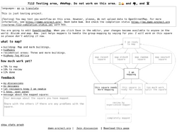
The damn project helps mappers by dividing a big area into smaller squares that people can map together. |
||||||||||||||||||||||||||||||||||||||||||||||||||||||||||||||||||||||||||||||||||||||||||||||||||||||||||||||||||||||||
| ||||||||||||||||||||||||||||||||||||||||||||||||||||||||||||||||||||||||||||||||||||||||||||||||||||||||||||||||||||||||
Divide and map. Now. -- the damn project -- helps mappers by dividing a big area into smaller squares[1] that people can map together.
The damn project supports collaborative mapping with the common workflow of map -> review -> done. Other supported use-cases include Review the work of the mapper, Download notes periodically, and Mapping with prepared data.
The damn project consists of several clients aimed at a specific group of mappers: Mapping beginner, mappers who ensure quality and/or help beginners improve, and mappers who manage areas to be mapped.
Running instances
- damn-project.org demonstrates the damn project by running the latest deployement version. There is API documentation of the server and by default, the JOSM
damnplugin uses the damn-project.org instance.RSS feeds are daily updated and all-areas info feeds are translated to fediverse (do not forget to click on the bell next to "Unfollow" if you want to be notified):
References
- ↑ Planar shapes, to be exact. New area can be divided automatically into rectangles, diamonds, hexagons, bricks, and rhombs. It is possible to provide already divided area with custom shapes.

