OpenMaps (IZE)
| OpenMaps | ||||||||||||||||||||||||||||||||||||||||||||||||||||||||||||||||||||||||||||||||||||||||||||||||||||||||||||||||||||||||||||||||
|---|---|---|---|---|---|---|---|---|---|---|---|---|---|---|---|---|---|---|---|---|---|---|---|---|---|---|---|---|---|---|---|---|---|---|---|---|---|---|---|---|---|---|---|---|---|---|---|---|---|---|---|---|---|---|---|---|---|---|---|---|---|---|---|---|---|---|---|---|---|---|---|---|---|---|---|---|---|---|---|---|---|---|---|---|---|---|---|---|---|---|---|---|---|---|---|---|---|---|---|---|---|---|---|---|---|---|---|---|---|---|---|---|---|---|---|---|---|---|---|---|---|---|---|---|---|---|---|---|
| Authors: | IZE, Ltd. | |||||||||||||||||||||||||||||||||||||||||||||||||||||||||||||||||||||||||||||||||||||||||||||||||||||||||||||||||||||||||||||||
| License: | Proprietary (2,39€ , free) | |||||||||||||||||||||||||||||||||||||||||||||||||||||||||||||||||||||||||||||||||||||||||||||||||||||||||||||||||||||||||||||||
| Platform: | iOS | |||||||||||||||||||||||||||||||||||||||||||||||||||||||||||||||||||||||||||||||||||||||||||||||||||||||||||||||||||||||||||||||
| Status: | Broken | |||||||||||||||||||||||||||||||||||||||||||||||||||||||||||||||||||||||||||||||||||||||||||||||||||||||||||||||||||||||||||||||
| Version: | 4.6.4 (2012-11-01) | |||||||||||||||||||||||||||||||||||||||||||||||||||||||||||||||||||||||||||||||||||||||||||||||||||||||||||||||||||||||||||||||
| Language: | English
| |||||||||||||||||||||||||||||||||||||||||||||||||||||||||||||||||||||||||||||||||||||||||||||||||||||||||||||||||||||||||||||||
| Website: | ||||||||||||||||||||||||||||||||||||||||||||||||||||||||||||||||||||||||||||||||||||||||||||||||||||||||||||||||||||||||||||||||
| Install: | ||||||||||||||||||||||||||||||||||||||||||||||||||||||||||||||||||||||||||||||||||||||||||||||||||||||||||||||||||||||||||||||||
|
Share & comment on OSM places via Twitter |
||||||||||||||||||||||||||||||||||||||||||||||||||||||||||||||||||||||||||||||||||||||||||||||||||||||||||||||||||||||||||||||||
| ||||||||||||||||||||||||||||||||||||||||||||||||||||||||||||||||||||||||||||||||||||||||||||||||||||||||||||||||||||||||||||||||
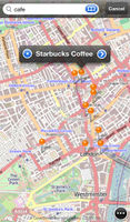
OpenMaps is an unmaintained map app based on OpenStreetMap and also Twitter. It lets you check in to and share OpenStreetMap places with your Twitter friends and has some great & useful map tools like such as route directions.
The feature to download maps for offline use was not compliant with Tile Usage Policy and created a problem for our volunteer-run OpenStreetMap server infrastructure, resulting in a block in October 2011 that has since been lifted. Development was discontinued in August 2013, but the application can still be installed from the iTunes App Store.
"OpenMaps for the iPhone is gonna do a bang-up job with this task. [...] Download OpenMaps!" - AppJudgement, Revision3
Features
- Pinpoint your location on the map with a tap of a button.
- Use the digital compass to rotate the onscreen map to match the direction you're facing. (Your device must have a digital compass built in in order for this feature to be available.)
- Turn off location services to reserve battery if you don't need them.
- Find out more info about places by simply tapping on their icons on the map.
- Search online for a location. (For best results when searching for addresses search this way "housenumber street city", e.g. "1 infinite loop cupertino".)
- Advanced users can add custom map types that they can browse.
Download maps for offline use.- Downloading OpenStreetMap standard tiles in this way is a breach of the Tile Usage Policy- Find out what people tweet around you or anywhere in the world by scanning the map for geotweets.
- Log in to Twitter to read your timelines and view your friends' tweets and mentions of you on the map.
- Send out checkin or comment tweets about OSM places and follow the recent Twitter conversation about them within the app.
- Do some basic edits to the map like editing tags, or even adding new places.
- Calculate the car, bike or pedestrian route with directions between any two locations with the help of online route providers. (YOURS online route provider has some limitations, such as no turn-by-turn directions, no support for transit point routing and long (> 200 km) routes.)
- Set transit points for the routes and bookmark the routes.
- Send feature requests and bug reports right within the app.
- Vote on these ideas and talk about them with other users, letting us know what your favorite ones are.
Follow ![]() @OpenMapsApp
@OpenMapsApp![]() on Twitter for updates.
on Twitter for updates.
