Open Door Logistics Studio
Open Door Logistics Studio is a standalone open source application for performing (a) geographic analysis of customers, (b) sales territory design, mapping and management and (c) 'last mile' transport planning using the jsprit vehicle routing toolkit. ODL Studio uses OSM mapping via the JxMapViewer2 project and also supports geocoding data in an Excel using OpenStreetMap's Nominatim webservice. It uses an Excel spreadsheet as its primary file format to allow easy integration into your existing workflow.
Go to www.opendoorlogistics.com for tutorials and to download ODL Studio. ODL Studio is released under a business-friendly LGPL licence.
Territory design
Open Door Logistics studio is an open source solution for territory design, territory management and territory mapping. It can be used to manage either sales territories – where a territory defines the area covered by a single salesperson or sales team or freight delivery territories – where a territory is the area covered by a transport depot. Generally speaking, well-designed sales territories are balanced - no territory is too big or too small. There are many benefits to optimising your sales territories, for example:
- Travel costs can be reduced by ensuring territories are geographically compact.
- Team morale can be improved by ensuring an amicable balance of sales revenue and workload.
- Customer satisfaction can be increased by ensuring your sales team have enough time to properly cater for their customers’s needs.
Watch the youtube video for a quick overview of territory planning in ODL Studio. ODL Studio includes the following features:
- Design territories using customer points or geographic building-blocks (zipcodes, postcode areas, etc...)
- Use geographic building blocks held in shapefiles – a popular format for geographic data.
- Aggregate statistics from customer points to building blocks.
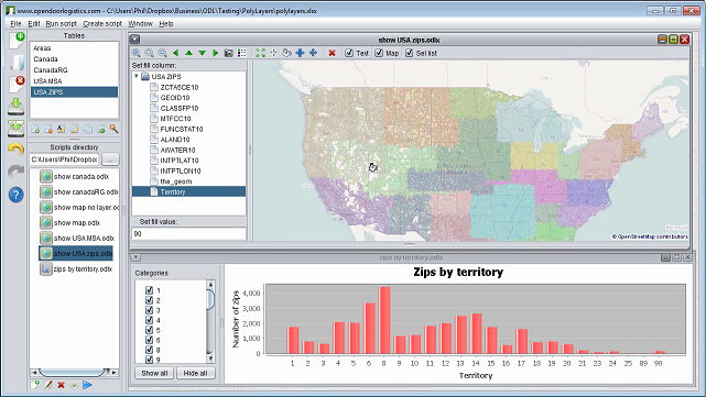
- Visualise territories in an interactive map.
- User-defined labelling highlights key building block statistics.
- Set territory colour using a separate table or let ODL Studio automatically assign one.
- Use the legend control to zoom on, show or hide territories.
- Design territories by painting them on a map, using the territory painter tool.
- Key territory statistics are shown in table controls or barcharts and automatically update as you paint.
- Experiment with different territory designs using undo and redo functions.
- Automatic territory designer
- Powerful algorithm automatically optimises territory design.
- Set different capacities (i.e. maximum sales or workload) per territory.
- Fix a subset of territory centres and optimise others.
- All data held in an Excel spreadsheet to ensure easy interoperability with other systems.
Territory mapping
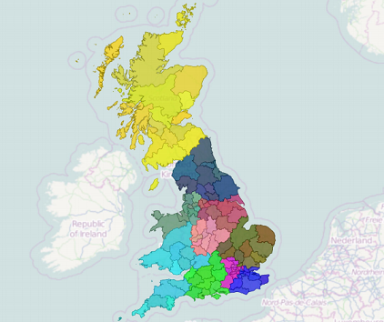
Using ODL Studio you can create beautiful territory maps for any type of geography where shapefiles are available – e.g. zipcode boundaries, postcode districts or areas. You can customise the maps by specifying colours for each territory, the building blocks that form the territory or blending a territory colour and block colour together. User-defined labelling can show sales or workload statistics, the building blocks zipcode, the territory name or any combination of these you choose.
You can export territory maps to pdf, together with text details & key statistics for the whole territory or its individual component blocks. Map images for each territory can be configured to:
- Highlight the current territory and grey-out surrounding ones.
- Show only the current territory.
- Show all territories, but zoomed-in on the current one.
- Combine a territory map with a map of your key customers.
Vehicle fleet planning
Vehicle routing systems help transport managers plan and optimise their daily vehicle routes, enabling them to reduce both fuel costs and fleet size. ODL Studio uses the jsprit vehicle routing library to provide the world’s first open-source vehicle routing & scheduling system.
Using ODL Studio with jsprit, you can:
- Automatically schedule an efficient set of vehicle routes to serve delivery points.
- Model routes using real road networks, provided by the Graphhopper project and powered by OSM data.
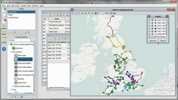
- Edit vehicle routes and see how your changes effect the route shape and key statistics.
- View tabular breakdowns of key statistics – e.g. total mileage and drivetime.
- View the routes in an interactive map.
- Analyse time usage using a Gantt chart control.
- Generate detailed reports and export them to pdf or other formats.
See the vehicle routing tutorial for more details or watch the youtube video.
Download link
Download ODL Studio for free from here.


