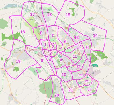
Oxford/Cyclox map 2009
Cyclox and the University of Oxford's Sustainable Transport Office are working together to create a printed map of the city and/or outlying, commutable areas with special relevance to cyclists, students, and university staff. User achadwick here is providing technical assistance.
More details as they emerge.
Past events
- 2008-12-04 - Informal mapping group meeting at FFTMC: 10 or so interested and motivated technical people... a good start! Handout:
- 2009-01-22 - More formal talk at the West Oxford Community Centre explaining OSM and what we can hope to achieve to Cyclox. 13 volunteers for a paper-based distributed mapping party over the next 3 or so weeks: see #Division of work below for the cake-slice diagram. Thanks to Simon Banks for organising food and the venue, Artem Pavlenko for coming along and saying hi, and to James Styring for getting people organised.
- Media:20090122_cycloxmap_presentation_wiki.pdf
- Media:20090122_cycloxmap_handout_wiki.pdf - there were B&W maps too: everyone got given their own custom one though; all were different. See below for links to the cakes slices and some images you can print out. --achadwick 14:12, 30 January 2009 (UTC)
- 2009-02-10 - Meeting with Ed Wigzell of OUED and others to discuss the University's requirements, catch up generally. Small requirements-gathering exercise; gathered info to come, watch this space.
Upcoming events & What's Next
- TODO: Organise a few more volunteers for the data gathering via Cyclox. Update: images below, break process out online.
- Get a printing deal worked out with a map publisher or a printing firm. Need to see where Ed Wigzell is with this.
- 2009-02-?? - Mapping workshop. Venue and date TBA. This will be hard-nosed data entry, getting information that people have gathered into the database. Maybe a little of a hackfest too, depends on who turns up. Work on a custom cycle map rendering for Oxford?
- Organise 'back cover' information: though I think that'll largely be more maps (yay!) - large-scale renderings of the city centre or problematic junctions and approaches spring to mind. Think about an A-Z style grid index too. Cyclox and University people to advise here.
Division of work
Data gathering
The image links in the table below reproduce what was handed out in physical paper form on the 22nd. Slices are further split into sub-pages for ease of printing; make sure you get all the bits you need if you want to lay claim to a slice.

| Slices and images | Volunteers |
|---|---|
| 1, 2, 3 | Sally and Colin |
| 4a, 4b | Artem Pavlenko |
| 5a, 5b | Stephen Gower |
| 6a, 6b, 12a, 12b, 13a, 13b, 14a, 14b, 26a, 26b | Low Carbon Headington |
| 7a, 7b, 8 | Simon Li |
| 9a, 9b | Richard Mann |
| 10 | Kate Dobson |
| 11a, 11b, 11c | James Styring |
| 12a12b | Simon Hunt |
| 15a, 15b | Unassigned |
| 16, 17a, 17b | Sue Baines |
| 18, 19a, 19b | Marcos Guillen |
| 20a, 20b | Glyn |
| 21a, 21b, 22a, 22b, 23a, 23b, 24, 25a, 25b | Unassigned |
Hope I've not misspelled anyone's name or missed any slices off. I'll try to do some of the ones that are left over --achadwick 21:35, 27 January 2009 (UTC)
On the 22nd Jan 2009, we handed out a "paper mapper's pack" consisting of a stamped addressed envelope plus an A4 map (or two), instructions, and a blank space for people to make notes. Reason for this being that many Cyclox members who'd like to take part don't have either the time or the technical know-how to contribute via the OSM website, but would still like a good map. The idea is that we get people to go out pencil-and-paper mapping over the course of the following few weeks, gather the information back, and enter what Cyclox members have been gathering in a mapping workshop later on. Hopefully this is a process that won't bottleneck anywhere.
Oxford is pretty well-mapped already, but we should be able to improve the data in a cool way, and hopefully knock together a Mapnik stylesheet that'll generate a really nice map for publication.