Philmont Scout Ranch
Quick Links to Philmont Locations
OSM Philmont Map Status
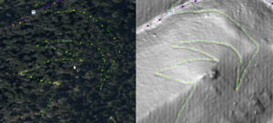
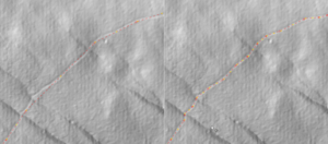
Extensive updates were made in March, 2022. Many of the updates were due to availability of LIDAR imagery in the JOSM editing tool. LIDAR makes constructed trails (i.e. treads cut into the side of slopes), eroded trails, tracks, and roads visible even under tree canopies. By using a combination of regular and LIDAR imagery most trails can be very accurately traced far more accurately than GPS track recordings from consumer grade GPS units.
2023 Updates
- New camps for 2023 have been added.
- The ridge trail from Clear Creek to Mount Phillips has been closed by Philmont in lieu of the new OATC trail. OSM has been updated to include "closed 2022" in this trail's name and the access property has been set to access=private to prevent GPS auto-routing algorithms from using this trail.
- Trail locations have been enhanced using the Strava heat map particularly in areas where LIDAR imagery does not clearly identify a trail.
2022 Updates
- Trails, tracks, roads, and water features updated using more accurate Bing imagery and USGS 3D Elevation Program LIDAR imagery.
- Trails found incorrectly tagged as tracks (and vice versa) have been corrected per 2021 published Philmont itinerary guides and maps.
- All tracks without proper names updated to use the Philmont "4WD", "Emergency Use", or "Out of Service" naming. Philmont does not name tracks or trails and it is important for mappers not to "make up" names (e.g. from-to destinations). First, doing so is not inline with OSM conventions. Second and more importantly, a crew calling into basecamp for emergencies would only confuse Philmont emergency responders by stating they are on a trail or road that someone has made up. They should report the type of track (or a trail) consistent with the published Philmont maps.
- Philmont trails that have previously created from-to trail names have been left alone - for now - with the exception of trails under construction. These have had "under construction" appended to the existing name for trails already entered or named simply "Under Construction" if added in 2022. Trails under construction also have FIXME tags to identify them to future mappers when trail construction is completed and the final route established. Current trail route information is that available from Philmont as of 2022 enhanced using LIDAR imagery for portions of such trails completed prior to the 2022 hiking season.
- All known Red Roof Inns (latrines) have been updated to have the same OSM tagging and named "RRI" for easy identification.
- The tag "foot=yes" has been added to all trails, tracks, and service roads to better support auto-routing for hiker profiles in mapping tools.
- Data points for trailheads (previously called "turnarounds") have been added or updated with the POI tag "highway=trailhead".
- Many livestock (burro) pens have been added with fences ways and tagged "landuse=farmyard".
- Campsite POIs found to be located on the main cabin of campgrounds have been moved off the main cabin building. Such overlaps are not in compliance with OSM tagging conventions as it places a camping site on top of a building and obscures on or the other when maps are generated. The campsite POI is for the campgrounds - not the main cabin. Main cabins should be simply "Main Cabin" otherwise using the name tag on the building itself (e.g. "MyCamp Cabin").
- Any "access=private" tags to Philmont features have been removed. Philmont is far from private (is permissive at best). Use of access=private particularly on roads, trails, and tracks will prevent most auto-routing programs from include privately tagged features.
- Structures located in the 2018 Ute Park Fire burn scar and likely burned have been left untouched on the assumption most will be rebuilt. Several new or rebuilt buildings in the burn scar have been added if visible in 2022 Bing imagery in JOSM.
- Non-existent trails based on some crew's GPS recording have been removed. See the section below on the Valle Vidal Unit Hiking.
- Several previously unmapped adits visible in LIDAR have been added.
- Changed all "Restricted Use" track names to "Emergency Use" consistent with a change in the way Philmont labels these tracks.
Trails, Tracks, Roads
As of September 2023, all trails, tracks, and roads at Philmont have been added to OSM. Some of these are based on GPS track data and some on tracing of aligned imagery (overhead, LIDAR, and Strava heat map).
Water Features
Water features such as lakes, reservoirs, and wetlands have for the most part been added. A good many rivers and streams have been added or updated using LIDAR imagery and accurately locate water features to within a few meters and should not need any adjusting.
Campsites
All campsites current as of 2023 have been added. Please do not move or otherwise alter the position of campsites.
Adjoining Philmont Use Properties
The Elliot Barker Wildlife Area, Colin Nesbitt Wildlife Area, Chase Ranch, Kimberlin Ponil Ranch (discontinued in 2022), Hect Place (formerly the Vermejo Park Ranch Heck Tract), Vermejo Park Ranch Greenwood Tract, UU Bar Ranch and Carson National Forest Valle Vidal Unit are adjoining properties which Philmont has permissive use. Property boundaries have been added.
Tiger Cleanup
Tiger cleanup has been completed for Philmont Scout Ranch and surrounding areas including the ranches, state parks, and portions of the Carson National Forest used by Philmont. Please DO NOT use Tiger as a data source as it is terribly inaccurate.
OSM Philmont Map Use
The first and primary source for crew navigation at Philmont is a compass and a Philmont produced topographic map. OSM maps containing Philmont data should only be used as a secondary navigation tool - preferably only by Crew Advisors. Crew Leader youth and the daily crew navigator (or "naviguesser") should stick with the basic map and compass. With that said, the Philmont data on OSM is excellent for use as a planning tool prior to a Philmont expedition.
Crew Advisors using OSM data downloaded to a GPS device should only used to verify their hunch that the crew has gone off course. Rather than telling the crew they've gone astray, it is best for the advisor to instead question the crew about the day's trek and let them figure it out.
- What direction are we supposed to be hiking today?
- What direction does the sun rise (or set)?
- Should the upslope be to our right or left?
- How long should it take us to reach our first landmark (e.g. trail fork, camp, stream, etc.)?
- How long have we been hiking?
Conventions for Mapping Philmont on OSM
The following conventions both follow OSM conventions and closely aligned with the Philmont published maps.
Trails and Roads
There are lots of trails but very few improved roads on Philmont. Most roads are considered tracks Philmont uses three distinctly defined tracks styles where OSM has only one track rendering style.
| Philmont Map | OSM Tags |
|---|---|
| Trail (dotted line) | The highway=path and surface=ground should be used for all trails. Optional tags is foot=yes. Please tag any trails (or tracks) open to burro packing with horse=yes. Name trails with endpoints at camps "CampOne - CampTwo Trail" using a dash vice the word "to" as every trail goes both ways. Rename any that have the "to" left with a dash. If a trail can quickly diverge to many different camp (has one or more forks in between and/or intersects with roads), simply name the with the name of the closest trail. |
| Highway | US 64 is tagged highway=primary. State road 21 is tagged highway=secondary. Both are tagged surface=asphalt and lanes=2. |
| Improved Roads | Improved roads are generally the dirt/gravel roads suitable for a Philmont bus up to a turnaround where crews are dropped off and picked up. Use highway=service. If you know the surface then use the surface tag accordingly. |
| 4WD Road | Four wheel drive (4WD) roads are mainly used to resupply camps. Some itineraries use 4WD roads for short distances when no foot trail exists. Tag all 4WD roads with highway=track and simply name them with name=4WD. |
| Emergency Use | Tag emergency use tracks with "highway=track" and "name=Emergency Use". All tracks previously named "Restricted Use" have been renamed to "Emergency Use" consistent with a change in the way Philmont refers to these tracks. |
| Out of Service | Tag out of service tracks with "highway=track" and "name=Out of Service". |
| Bridges | Map bridges as you would normally in OSM. Most bridges qualify as beam structures. Set the tags bridge=yes and layer=1. |
DO NOT USE access=private. The primary reason to not use access=private is most auto-routing will not include private ways in routes. If all the trails and tracks in Philmont were tagged private auto-routing would not work. OSM conventions actually frown upon tagging house driveways private (unless they have security gates and private signs) as most guest are allowed to pull into the driveway.
Routes
Do not enter Philmont Itinerary Guidebook routes in Open Street Map. Philmont itineraries change each year and thus have to be updated yearly. Let each crew create their own trek using their assigned itinerary. There are many tools and applications using OSM data (e.g. Garmin Base Camp, OSMand, CalTopo, GAIA, All Trails, etc.) that crews can use for route planning. OSM is for permanent features, not temporary. Routes should only be applied only when mapping expansive trails such as the Appalachian Trail that travel along trails and roads of other names.
Water Features
When adding water features, use the USGS 3D Elevation Program LIDAR imagery available in the JOSM editor. The bottom of ravines, dams, lakes, and similar are clearly visible in LIDAR. Large water bodies appear as flat areas in LIDAR and even if the water level is low, will clearly show the banks of rivers and lakes. Map to the banks, not the water level as of the last overhead imagery.
| Philmont Map | OSM Tags |
|---|---|
| Springs | natural=spring |
| Improved Water Sources | Wells use man_made=water_well. For windmills use man_made=windmill. |
| Stream | waterway=stream - Be sure the way flows downhill the way water flows downhill. If a stream is named on the Philmont or a USGS map please use the name tag to name the stream. If the stream is not named on the map but the valley or canyon the stream it is in is named, apply the valley or canyon name to the stream. Please do not make up names for streams. |
| Intermittent Stream | waterway=stream and intermittent=yes |
| Streams crossings | For trails and tracks, simply intersecting the stream and trail at a common point is enough. Trails following narrow ravines will cross many time so please DO NOT USE ford=yes for every trail-stream crossing. Consider only tagging such crossing at major streams where streams flow year round. Do you the ford=yes tag on tracks where vehicles do indeed drive through streams (if a wide stream, use a line vice point much like a bridge). If there is a constructed bridge, tag the segment over the water with bridge=yes, foot=yes, and if known, surface=wood as appropriate. For streams crossing under roads, break up the stream way to have a point on either side of the road and tag the portion running under the road as tunnel=yes and layer=-1. |
| Lakes, ponds, and natural basins | Draw a way around the bank or high water mark and tag the way with natural=water. If the water feature is intermittent add intermittent=yes. Add a name tag for named water features. A natural basin is a low spot where water collects but never drains such as Devil's Wash Basin. |
| Reservoirs | Draw a way around the high water mark and tag the way with man_made=reservoir and reservoir_type=water_storage. If the frequently goes dry add intermittent=yes. Add a name tag for named reservoirs. |
| Basins | A basin in OSM terms is a man made retention ponds to filter runoff from roads and other improved areas. They may be found in Philmont back country to prevent erosion, particularly in burn scars where they are built as part of the fire recovery effort. Use landuse=basin and basin=retention. |
Buildings
Map buildings by outlining the building and tagging building=yes. Please further refine the building with the name, type, and any other relevant information as you would normally tag a building in OSM. Tag Red Roof Inns at minimum with name="RRI", building=yes, amenity=toilets, toilets:disposal=pitlatrine, and unisex=yes. The best way to place an unmapped Red Roof Inn is to copy an existing one and the rotate to align (select way and use ctrl-shift and mouse to rotate in JOSM). Please do not bother tagging back country latrines (with no structures) as these tend to migrate locations from year-to-year as pits are filled and new ones are dug.
Valle Vidal Unit Hiking
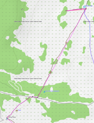
Since 1988, Philmont has trekked through pieces of the 100,000-acre Valle Vidal. In the "Valle", building new trails is not allowed and thus most treks through the Valle require a crew "bushwack" using map and compass (take a bearing, pick a landmark, walk to it, repeat). Crews are also required to "prairie walk" dispersed rather than behind each other in a column. This is to prevent tromping down plants creating a trail where there should not be one (thing Leave No Trace). To encourage this practice, please do not convert GPS tracks through the Valle into paths/trails where there is no established trail. When creating trails through the Valle using Base Camp, simply convert the activity to direct routing (same when using a GPS in the Valle - but of course that would be cheating). See the example of how well my 2019 crew did.
Using GPS Tracks
By far the most accurate way to map trails is using GPS tracks. Please use these when possible and please upload public tracks to OSM so others can use them and NOT redo trails already mapped to accurate tracks. Tag uploaded tracks with "Philmont Scout Ranch." It is easy to pull OSM tracks when downloading OSM data into JOSM by clicking the "Raw GPS data" checkbox in the download window. Use your best judgement before using some oft these tracks as they are of poor quality (double check using imagery to make sure they are at least close). Preference would be to not perform any automatic smoothing on the GPS track as it tends to cut out some switchbacks and straighten out curves. Instead, compensate for variations when tracing the track into OSM (e.g. GPS errors, obvious diversions from the trail for nature calls, etc.).
Note that Philmont has started publishing GPS track data to their website GIS page. However a lot of it is of low quality so be careful if you use it for mapping. GIS data available as of December 2020 has already been considered and the data already in OSM is far more complete and accurate than most the Philmont data.
Using Imagery
As of March 2022, the best imagery sets in JOSM are the bing imagery and and USGS 3D Elevation Program (LIDAR) imagery. Resolution of the Bing imagery is at a higher resolution than available when the initial Philmont mapping was conducted. The USGS LIDAR imagery is most useful when the ground is obstructed by vegetation in satellite imagery. Both imagery sets are aligned pretty good. No imagery offsets were used in the 2022 updates.
Other Resources
Philmont Scout Ranch
The Philmont Scout Ranch web site is the go-to source for information Philmont especially for crews planning Philmont treks.
The Philmont Spatial Data page contains a link to a download of spatial data provided by the Philmont GIS department. They only provide a Google Earth KMZ formatted file for which there are plenty of converters available on the Internet for converting KMZ to the GPX format common to most handheld GPS devices. Note the Philmont provided spatial data is generally not useful for auto-routing software as the tracks are not connected. However, they do provide routes for each trek itinerary.
The Philmont topographical maps are available for purchase from the Tooth of Time Traders.
OSM-PHILMONT-GARMIN-MAP
This map is a custom build for Philmont and surrounding areas that uses the same bread crumbs for trails and tracks as the printed Philmont maps making it easy to go back a forth between the two. Elevation data is shown using hill shading. An installer is included to install the map into Garmin Base Camp making it easy to perform itinerary planning and to create routes for each day's trek. Installed on a Garmin GPS, add the OpenTopoMap (see below) US-West Garmin contours for both hill shade and contours. The contours map can be turned on or off to reduce screen clutter.
https://www.gpsfiledepot.com/maps/view/879
OpenTopoMap Garmin Maps
Next to the OSM-PHILMONT-GARMIN-MAP map, the OpenTopoMap distribution is the best option as it is updated more often (monthly) than the USA OSM Topo Routable maps (3-4 months). You will want to download and install the North-America US-West Garmin and Garmin Contours maps. Contour lines can be turned on or off by turning the US-West Garmin Contours map on or off on your Garmin device.
https://garmin.opentopomap.org/#north_america
GPS File Depot
User mhinch has maintained a downloadable collection of Philmont trails for several years. See the Philmont Scout Ranch Trails Map on GPS File Depot.
USA OSM Topo Routable
This USA OSM Topo Routable site provides downloadable topographic maps based on OSM data and formatted for Garmin GPS devices. The maps are provided in six sections - download the Mountain section to include Philmont. Note it can be difficult to use the auto-route function on a GPS device as the availability of trails and auto-route created may not be the route recommended by your itinerary. Save auto-route for emergencies or when near your campsite but always in conjunction with the Philmont topographical maps.
Garmin Base Camp
Garmin Base Camp is a free download from Garmin intended for use with your Garmin GPS device. Garmin, of course, wants you to purchase their topographical maps. However, other maps formatted for download to Garmin GPS devices (such as the USA OSM Topo Routable maps above) can be loaded into Base Camp and use to create routes. Once created, the map and routes can be downloaded to Garmin devices using Base Camp. After returning home, you can download your Philmont tracks and export to GPX format for upload to OSM to contribute to maintenance of the Philmont map in OSM. See the Base Camp website for information on how to use Base Camp.
Garmin Base Camp Map Transfer Issue
There is a bug in the MapInstall application that comes in Base Camp 4.7.x versions. It causes crashes/failures when using Base Camp to transfer a map (like USA OSM Topo) to a Garmin GPS. The workaround is to use version 4.6.2 to do this transfer. Multiple versions can be installed so you don't have to give up 4.7.x. See info on this bug and workarounds here: Do NOT Update to Base Camp 4.7.0 – MapInstall 4.2.0 is broken!
Combining Routes in Base Camp
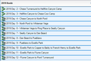
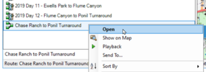
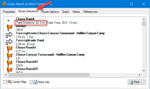
When creating your Philmont routes, the recommendation is to create one track for each day. Once downloaded to a GPS it is easy to pull these up. In Base Camp, one can open all these individual tracks but the elevation plot produces draw over themselves. To get an elevation plot for the entire trek it is easiest to combine all the data tracks into a single track so an elevation graph for the entire trek can be generated. Doing so is also convenient for comparison to the elevation track in the Itinerary Guidebook as a verification your crew mapped the recommend route. These are the steps to combine daily routes into an overall route.
| Step | Description | Screenshot |
|---|---|---|
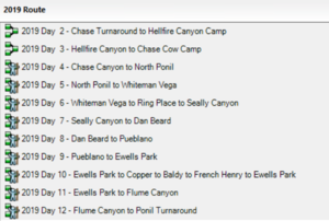
| 1 | Create routes for each day. Hiking starts at Philmont on day 2 (day 1 is in base camp). A space can be used in front of the single digit days for the routes to naturally sort in order (using the date you'll be on the trail that day is another method). | |
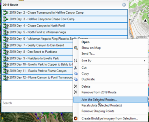
| 2 | Selected the routes you want to combine. | |
| 3 | Use the right-click mouse button menu to select "Joint the Selected Routes. | |
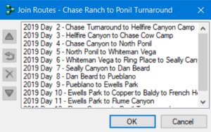
| 4 | Ensure the routes are listed in the correct order. If out of order, select a day out of order and then use the up/down buttons to put it in order (repeat until all are in order). | |
| 5 | Important: Select No - You don't want to delete your original routes. | |
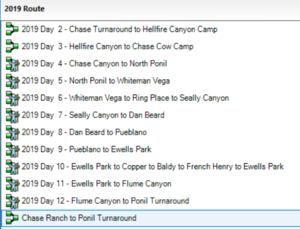
| 6 | Your overall routes is created using the names of the start and end points. | |
| 7 | Right click on the overall route and select Open. | |
| 8 | Select the Route Direction tab and see your total trek distance. |
Garmin GPS Power Saving Tips
The following tips will maximize power saving when using a Garmin GPS. This tips were put together based on experience with both Garmin 64 and 66 GPS handheld units.
- Under Setup -> Display
- Set the backlight timeout to 15 seconds.
- Turn on Powersave. This requires using the power button to turn the display back on. Otherwise, every time a key gets hit while the unit is bouncing around the display will come on.
- Turn the GPS off during long breaks. This will also give you more accurate distance because even when sitting still, the GPS is recording fixes that bounce all over due to fix accuracy errors.
Quick Start for Using Philmont Trails in OSM on your Crew Trek
This quick start is more or less specific to folks who have Garmin GPS units the plan to carry and users of Garmin Base Camp that want experiment with routes to determine the best route for your trek. Philmont rules require crews to camp at the designated site each night Violators of this rule my have their trek terminated as they put themselves and Philmont staff at risk should an evacuation such as that during the 2002 Ponil Complex fire caused. With that said, crews are in control of which trails they take each day to the designated camp. My 2019 did this twice, once to divert by a staffed camp to get another stamp on their Philmont Passports and once to optimize our Baldy side hike and food pickup day.
For this second route, the Trek book had a crazy route from Ewells Park to Baldy Town to pick up food and then up and over Baldy down to French Henry for program before returning to Ewells Park. Issues with this Trek book route were
- It's best to get an early start up Baldy so the crew can be up and down before the afternoon thunderstorm,
- the commissary at Baldy Town doesn't open until after 8 a.m.,
- picking up food before the ascent means those packing it have to carry it up and over, and
- the ascent from Baldy Town is steep and for each two step forward you slide one step back.
To avoid these issues at the cost of a few extra (but easy) miles, our crew was on the trail by 5 a.m. passing through Baldy Town taking the easy back trail to Copper Park and then up the primo switchbacks traversing the ridge up and over Baldy through Baldy Town where we then picked up food before taking an easy trail to French Henry. The difference was about three miles but with a much better elevation profile, something we knew well ahead of time using the steps below.
Step 1 - Install Garmin Base Camp
Garmin Base Camp is a free download for your computer and does not require a Garmin device. If you do have a Garmin GPS and plan to take it with you, download version 4.6.2 of Base Camp vice the latest version 4.7.x. There's a bug in the MapInstall program which prevents you from using Base Camp to download the map to your device. See Garmin Base Camp below for more details.
If you have installed the OSM-PHILMONT-GARMIN-MAP you can stop here and follow the instructions in the readme.txt file, then jump to #5 after you have created some routes.
Step 2 - Install the Mountain USA OSM Topo Routable Map into Base Camp
The USA OSM Topo Routable site provides downloadable topographic maps based on OSM data and formatted for Garmin GPS devices. Installation is as easy as downloading the zip file, unzipping it, and running an installation bat file. Being a routable map, you can pick a destination and create a route that follows the trails vice a point-to-point direct vector.
Step 3 - Use Base Camp to Create your Preferred Trek Route
Simply start with your drop-off point (or Philmont's base camp) and create your route. The best approach is to create a new route for each day. This makes it easy to create alternative routes to play the "what if" game. When you have your preferred routes, follow the step below in Combining Routes in Base Camp to see your overall mileage.
Step 4 - Use Base Camp to Install the Mountain USA OSM Topo Map onto your Garmin GPS
If you are using Base Camp 4.7.x, you may have to uninstall it and install version 4.6.2. IMPORTANT: Create a backup first before you install. Note the backup from 4.7.x is not backward compatible so you won't be able to import the routes just created into 4.6.2. That's OK as once you've installed the map you can uninstall 4.6.2 and reinstall 4.7.x. Supposedly, this bug is fixed in Base Camp 4.8.x but as of this writing that version is only available for Mac and not Windows.
Step 5 - Use Base Camp to Transfer Trek Routes to your Garmin GPS
It is now a simple matter to push your routes to your GPS for use on you trek. As discussed above, your crew should use map and compass but as a leader, you can use yours to see how far remains and use that information to decide how long you want them to take a wrong trail before asking them to "check your maps."
Disclaimer
The OSM Philmont Scout Ranch mapping project has no affiliation with Philmont Scout Ranch.
As always, the OSM disclaimer and copyright apply.
