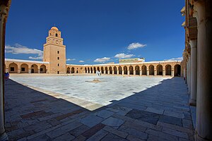
Proposal:Courtyard
| Courtyard | |
|---|---|
| Proposal status: | Proposed (under way) |
| Proposed by: | Fkv |
| Tagging: | man_made=courtyard |
| Applies to: | |
| Definition: | an area enclosed by a building |
| Statistics: |
|
| Rendered as: | usually only name and/or ref |
| Draft started: | 2015-03-06 |
| RFC start: | 2015-03-06 |
Rationale
A courtyard is an area open to the sky and horizontally (completely or to the most part) enclosed by buildings.
Alternative keys such as landuse=*, leisure=*, place=* or building:part=* do not really match this, see the thread "courtyards" in the tagging mailinglist. man_made=* seems best suited, because a courtyard is man made (as opposed to natural). Just as man_made=cutline, a courtyard is a a clear space and defined by its surroundings.
How to Map
- Quick mapping: Create a node in the middle of the courtyard.
- Exact mapping: Draw the enclosed area, or the area to which the name applies. It is permitted to include arcades, making the courtyard overlap with the building.
Then, set man_made=courtyard and attributes such as name=*.
If the courtyard is not at the outer ground level of the building, add level=*.
Rendering
Depends on the additional tags. The courtyard should be labelled with name=* or ref=* if present.
Courtyards that are part of the building polygon (because level is >0) should be outlined or rendered in a different tone than the rest of the building.
Useful Combinations
Examples
- 293340874
 293340874
 - 2208835
 2208835 - the place=locality tags would be replaced with man_made=courtyard
Discussion
Use the Talk page.
Voting
Not yet.

