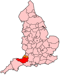
Somerset
| V・T・E |
| latitude: 51.095529, longitude: -2.832232 |
| Browse map of Somerset 51°05′43.90″ N, 2°49′56.04″ W |
| Edit map |
|
External links:
|
| Use this template for your locality |
Somerset is a county in South West England at latitude 51°05′43.90″ North, longitude 2°49′56.04″ West.
The ceremonial county of Somerset, in the South West region of England, is made up of the non-metropolitan county of Somerset together with the unitary authorities of Bath and North East Somerset 81941![]() 81941 and North Somerset 80277
81941 and North Somerset 80277![]() 80277 (highlighted in Orange in the map below).
80277 (highlighted in Orange in the map below).
The relation for the ceremonial county of Somerset boundary is 72894![]() 72894. The county has borders with the counties of Bristol, Devon, Dorset, Gloucestershire and Wiltshire
72894. The county has borders with the counties of Bristol, Devon, Dorset, Gloucestershire and Wiltshire
Districts
The non-metropolitain county of Somerset is divided into five districts:
| Number complete | |||||
|---|---|---|---|---|---|
| Area | Cities | Towns | Villages | Notes | Boundary Relation |
| Mendip [1] | |||||
| Sedgemoor [2] | |||||
| South Somerset [3] | |||||
| Taunton Deane [4] | |||||
| West Somerset [5] | |||||
Towns in Somerset
This is a list of towns and cities within the ceremonial county of Somerset.
Taken from the Wikipedia page: Template:Somerset
- Alcombe
- Axbridge
- Bath
- Bridgwater
- Bruton
- Burnham-on-Sea
- Castle Cary
- Chard
- Clevedon
- Crewkerne
- Dulverton
- Frome
- Glastonbury
- Highbridge
- Ilminster
- Keynsham
- Midsomer Norton
- Minehead
- Nailsea
- North Petherton
- Portishead
- Radstock
- Shepton Mallet
- Somerton
- South Petherton
- Taunton
- Watchet
- Wellington
- Wells
- Weston-super-Mare
- Wincanton
- Wiveliscombe
Roads in Somerset
| %age roads complete | |||||
|---|---|---|---|---|---|
| Postal Area | Town Name | Tracks | Mapped | Labelled | Notes |
| Roads between towns and villages | 0% | 0% | 0% | ||
| Bridgwater | 0% | 0% | 0% | ||
| Chard | 0% | 0% | 0% | ||
| Crewkerne | 0% | 0% | 0% | ||
| Frome | 0% | 0% | 0% | ||
| Glastonbury | 0% | 0% | 0% | ||
| Minehead | 0% | 0% | 0% | ||
| Somerton | 0% | 0% | 0% | ||
| Shepton Mallet | 0% | 0% | 0% | ||
| Street | 0% | 0% | 0% | ||
| Wellington | 0% | 0% | 0% | ||
| Wells | 0% | 0% | 0% | ||
| Yeovil | 5% | 0% | 0% | ||
Quantock Hills Area of Outstanding Natural Beauty
Following an of Information request and the copies of the order and [6] subsequently provided, the boundary of the Quantock Hills AONB 113802638![]() 113802638 has now been mapped. The boundary has been tagged as a national park because the AONBs have equivalent status to National Parks, have the same landscape qualities, and are created under the same legislation (National Parks and Access to the Countryside Act, 1949), and are designated by the National Parks Commission. M Briggs 20:20, 1 June 2011 (BST)
113802638 has now been mapped. The boundary has been tagged as a national park because the AONBs have equivalent status to National Parks, have the same landscape qualities, and are created under the same legislation (National Parks and Access to the Countryside Act, 1949), and are designated by the National Parks Commission. M Briggs 20:20, 1 June 2011 (BST)

