Sustrans Millennium Mileposts
Sustrans commissioned 'Millennium Mileposts' across the country as part of early work on the National Cycle Network in the UK.
Around 2009 Sustrans GIS department permitted OSM to have the list of their Millennium Mileposts (and also Artwork) that exists on the National_Cycle_Network. The full listing can be found in the table below. In 2016 they made the data available as open data (broken link, kept here for purposes of verification). Sustrans are interested in situations where OSM contributors map milepost locations more accurately than in these records. 2019 edit: Sustrans open data current list contains known milepost locations, although some have alternate MPxx ID numbers to earlier lists.
Please add links to OSM data to the table and add the Sustrans ID tag to the OSM data to make it easier to find. suggest using sustrans_ref=* as the key when tagging.
Why not add a photo too, like some of the Yorkshire and Humberside ones.
Mileposts already in OSM are tagged with ncn_milepost=* where the value is one of mills, dudgeon, mccoll or rowe. These will appear on the cycle map on zoom level 13 or higher.
In some instances it is difficult to distinguish between two or more mileposts. Blackadder can help sort these instances out from additional information he has from Sustrans
Channel Islands
| Region | Sustrans ID | Milepost Type | Location | OSM data link | Icon | Photo |
|---|---|---|---|---|---|---|
| Channel Islands | unknown | Mills | Victoria Avenue, Saint Helier, Jersey | 6680166504 |
||
| Channel Islands | unknown | McColl | St Aubin, Jersey | 7095175674 |

East Midlands Region
| Region | Sustrans ID | Milepost Type | Location | OSM data link | Icon | Photo |
|---|---|---|---|---|---|---|
| East Midlands | MP1072 | Mills | Phoenix Park, London Road, Greenhill, North West Leicestershire, Leicestershire | 7012102321 |
||
| East Midlands | MP772 | Dudgeon | Market Harborough (western end of Welland Park, by bridge over river), Leicestershire | 459663748 |
||
| East Midlands | MP885 | Dudgeon | Redmile, Leicestershire Sustrans open data locates milepost here |
|||
| East Midlands | MP1000 | Dudgeon | Redmile Walk, by Grantham Canal, Earlesfield Lane, Earlesfield, Grantham, Lincolnshire | 6418243060 |
||
| East Midlands | MP51 | McColl | Great Central Way, Glen Parva, Blaby, City of Leicester | 197738956 |
||
| East Midlands | MP52 | McColl | Cloud Trail Greenway, Breedon on the Hill, North West Leicestershire, Leicestershire | 2493915341 |
||
| East Midlands | MP53 | McColl | Brampton Valley Way, Great Oxendon, Harborough, Northamptonshire | 502520721 |
||
| East Midlands | MP54 | McColl | Watermead Park, Leicester Sustrans open data locates milepost here |
|||
| East Midlands | MP204 | McColl | Loughborough, Mountsfields School Sustrans open data locates milepost here |
|||
| East Midlands | MP205 | McColl | Beacon Academy, Woodthorpe Road, Charnwood, Leicestershire | 7026962627 |
||
| East Midlands | MP335 | McColl | NCN 6, near Cracknuts Lane, Great Houghton, Northampton, Northamptonshire | 7124515196 |
photo on Waymarking.com | |
| East Midlands | MP336 | McColl | Northampton (Becketts Park) Sustrans open data locates milepost here |
|||
| East Midlands | MP386 | McColl | Leicester Sustrans open data locates milepost here |
|||
| East Midlands | MP387 | McColl | Grand Union Canal Market Harborough Arm, near to Harborough Road, Foxton, Harborough, Leicestershire | 7026956084 |
||
| East Midlands | MP388 | McColl | Public Footpath (A67), by River Welland, Harborough, Leicestershire | 502520252 |
||
| East Midlands | MP389 | McColl | Countesthorpe Leysland Community College, Winchester Road, Blaby, Leicestershire | 4999355572 |
||
| East Midlands | MP399 | McColl | Derby Road, Egginton CP, South Derbyshire, Derbyshire | 7026185722 |
||
| East Midlands | MP487 | McColl | Notts/Lincs county boundary | 192718605 |
||
| East Midlands | MP540 | McColl | Stamford Sustrans open data locates milepost here |
|||
| East Midlands | MP567 | McColl | Darley Playing Fields, Folly Road, Cathedral Quarter, Darley Abbey, Derby | 2194919812 |
poor photo | |
| East Midlands | MP734 | McColl | Caistor Road / Limber Road, Swallow CP, West Lindsey, Lincolnshire | 663418675 |
||
| East Midlands | MP738 | McColl | Lincoln | 663965821 |
||
| East Midlands | MP910 | McColl | Harlaxton Wharf, The Drift, Harlaxton CP, South Kesteven, Lincolnshire | 6418243056 |
||
| East Midlands | MP998 | McColl | Grantham, Stenwith Sustrans open data locates milepost here |
|||
| East Midlands | MP4 | Mills | Worthington Sustrans open data locates milepost here |
|||
| East Midlands | MP16 | Mills | Water Rail Way, near to Ferry Lane, Washingborough CP, Lincoln, Lincolnshire | 663977736 |
||
| East Midlands | MP145 | Mills | Greenwich Drive South, California, Mackworth Estate, Derby | 7026130709 |
||
| East Midlands | MP173 | Mills | Melbourne Road, Nottingham | 1781726472 |
||
| East Midlands | MP267 | Mills | Draycott | 2493915344 |
||
| East Midlands | MP270 | Mills | near to Red Cross Street, Green Hill, Grantham, Lincolnshire | 6418243047 |
||
| East Midlands | MP338 | Mills | Chesterfield | 2337674034 |
||
| East Midlands | MP397 | Mills | Derwent Valley Heritage Way, near to Main Road, Elvaston Meadows, Elvaston CP, South Derbyshire, Derbyshire | 2604554729 |
||
| East Midlands | MP398 | Mills | Long Eaton, West Park | 1265404041 |
||
| East Midlands | MP401 | Mills | Great Northern Greenway, Bearwardcote CP, South Derbyshire, Derby | 6695507050 |
||
| East Midlands | MP488 | Mills | Skellingthorpe | 192703888 |
||
| East Midlands | MP492 | Mills | Boundary Wood, near to Gilbert Way, Blidworth CP, Newark and Sherwood, Nottinghamshire | 1535824630 |
||
| East Midlands | MP532 | Mills | Linwood Road, Linwood CP, West Lindsey, Lincolnshire | 663953475 |
||
| East Midlands | MP604 | Mills | Main Street, Willoughby Waterleys, Harborough, Leicestershire | 7024410885 |
||
| East Midlands | MP1121 | Mills | West of Bardney on NCN1, Water Rail Way, Washingborough CP, Lincoln, Lincolnshire | 663979268 |
||
| East Midlands | MP735 | Mills | Bardney | 663979363 |
||
| East Midlands | MP737 | Mills | Thoresway | 663427245 |
||
| East Midlands | MP771 | Mills | Brampton Valley Way, Great Oxendon, Harborough, Northamptonshire | 479295502 |
||
| East Midlands | MP830 | Mills | Melton Country Park, near to Harvey Street, Melton, Leicestershire, East Midlands | 7024364032 |
||
| East Midlands | MP1001 | Mills | Denton Wharf, Casthorpe Road, Denton CP, South Kesteven, Lincolnshire | 7024326206 |
||
| East Midlands | MP1014 | Mills | Belton, North West Leicestershire, Leicestershire | 5776805891 |
||
| East Midlands | MP1069 | Mills | Running Furrows Gate, Kingscliffe Road, Gonerby Hill Foot, Grantham, Lincolnshire | 7024286264 |
||
| East Midlands | MP125 | Rowe | Brampton Valley Way, Boughton, Northampton, Northamptonshire | 7026938363 |
||
| East Midlands | MP126 | Rowe | Brampton Valley Way, Lamport, Daventry, Northamptonshire | 7024361401 |
||
| East Midlands | MP146 | Rowe | Alvaston Park Lake, Persian Close, City Point, Crewton, Derby | 1642965832 |
||
| East Midlands | MP328 | Rowe | Hazel Gap (A616) Budby Drive, Carburton, Mansfield, Nottinghamshire | 2097297717 |
||
| East Midlands | MP340 | Rowe | Staveley | 2337672817 |
photo on Waymarking.com | |
| East Midlands | MP400 | Rowe | Great Northern Greenway, Etwall CP, South Derbyshire, Derbyshire | 6695541957 |
||
| East Midlands | MP486 | Rowe | Harby | 192723383 |
||
| East Midlands | MP491 | Rowe | Witham Way Country Park, Haworth Way, Boston, Lincolnshire | 7024314589 |
||
| East Midlands | MP493 | Rowe | Clipstone | 3160433832 |
||
| East Midlands | MP494 | Rowe | Newstead | 2359493800 |
||
| East Midlands | MP495 | Rowe | Bestwood Country Park, Bestwood Road, Bestwood Village, Gedling, City of Nottingham | 3613700125 |
||
| East Midlands | MP496 | Rowe | Worksop/Clumber Park | 175882918 |
||
| East Midlands | MP497 | Rowe | Chesterfield Canal, Shireoaks, Bassetlaw, Nottinghamshire | 7024291358 |
||
| East Midlands | MP539 | Rowe | Woolsthorpe By Belvoir CP, South Kesteven, Lincolnshire | 7024282513 |
||
| East Midlands | MP683 | Rowe | in carpark off Station Road, Ashbourne CP, Derbyshire Dales, Derbyshire | 7026960015 |
||
| East Midlands | MP736 | Rowe | Thoresway CP, West Lindsey, Lincolnshire | 663427900 |
||
| East Midlands | MP999 | Rowe | Granta Crescent, Harrowby Estate, Grantham, Lincolnshire | 7024283969 |
||
| East Midlands | unknown | Dudgeon | Fingers Lake Car Park, Watermead Country Park, Watermead, Leicester | 7026945642 |
||
| East Midlands | MP339 | Rowe | Trans-Pennine Trail, Station Road, Rennishaw, North East Derbyshire, Derbyshire located in 2024 but has been here for years |
8184083819 |
https://www.cyclestreets.net/location/207784/cyclestreets207784.jpg |


East of England Region
| Region | Sustrans ID | Milepost Type | Location | OSM data link | Icon | Photo |
|---|---|---|---|---|---|---|
| East of England | MP384 & MP1097 & MP1122 | Mills | Ipswich Hospital, Heath Road, Broke Hall, Ipswich, Suffolk | 283375599 |
||
| East of England | MP1123 | Mills | Rushbrooke with Rougham, West Suffolk, Suffolk | 895907479 |
||
| East of England | MP1132 | Mills | Limbury Mead Park, Westmorland Avenue, Limbury, Luton | 7006148201 |
||
| East of England | MP1133 | Mills | Watford Rugby Football Club, Radlett Road, Watford Heath, Watford, Hertfordshire | 6533479712 |
||
| East of England | MP587 | Dudgeon | Ryefields, Thurston, Mid Suffolk, Suffolk | 6349101803 |
||
| East of England | MP601 | Dudgeon | Needham Market Sustrans open data locates milepost here |
|||
| East of England | MP48 | McColl | Prince of Wales Road, Lakenham, Norwich, Norfolk | 107153027 |
||
| East of England | MP149 | McColl | Middle Mill, Handford Place, Myland, Colchester, Essex | 426858755 |
photo on flickr | |
| East of England | MP549 | McColl | Whitlingham Visitor Centre, Whitlingham Lane, Trowse with Newton, South Norfolk, Norfolk | 107109493 |
||
| East of England | MP551 | McColl | Ingloss Lane (near water tower), Loddon, South Norfolk, Norfolk | 283338154 |
||
| East of England | MP667 | McColl | Birch Road / Garlands Farm, Layer-de-la-Haye, Colchester, Essex | 426858758 |
photo on flickr | |
| East of England | MP710 | McColl | Whittlesey Road, March, Cambridgeshire note: Milepost on the Greenwich Meridian |
322901810 |
||
| East of England | MP795 | McColl | Whittlesey, Fenland, Cambridgeshire | 196347953 |
||
| East of England | MP968 | McColl | King's Dyke, near to Framlingham Road, Cardea, Peterborough, City of Peterborough | 196277593 |
||
| East of England | MP975 | McColl | Peterborough, Castor, Ferry Hill, near Milton Ferry Bridge | 160126243 |
||
| East of England | No ref inferable: lies between 973 and 974 | McColl | Peterborough, Broadway, south corner of Central library | 6853411014 |
||
| East of England | MP11 | Mills | Sandringham Railway Path, Lynnsport, King's Lynn | 430364835 |
||
| East of England | MP102 | Mills | NCN 51, near to Cross Cut Court, Hythe, Colchester, Essex | 417657767 |
photo on flickr | |
| East of England | MP106 | Mills | Alban Way, Colney Heath, St Albans, Hertfordshire | 280130223 |
||
| East of England | MP150 | Mills | Ferry Marsh (Colne Local Nature Reserve), Wivenhoe Trail, Wivenhoe, Colchester, Essex | 280552734 |
photo on flickr | |
| East of England | MP210 | Mills | Hadleigh, Suffolk Sustrans open data locates milepost here |
|||
| East of England | MP218 | Mills | Queen Elizabeth Way / Cat's Bottom Road, Sandringham, King's Lynn and West Norfolk, Norfolk | 667479517 |
||
| East of England | MP299 | Mills | Rectory Wood, Hodings Road, The High, Harlow, Essex | 7033984233 |
||
| East of England | MP396 Alternate Sustrans ID: MP1131 |
Mills | Gogg's Mill Road, Fakenham, North Norfolk, Norfolk | 721057742 |
||
| East of England | MP548 | Mills | Six Hills Way, Bedwell, Stevenage, Hertfordshire | 160088982 |
||
| East of England | MP550 | Mills | The Street, Geldeston, South Norfolk, Norfolk | 7033873207 |
||
| East of England | MP552 | Mills | Bridge Street, Loddon, South Norfolk, Norfolk | 7033871988 |
||
| East of England | MP553 | Mills | Lower Road, Rockland St. Mary, South Norfolk, Norfolk | 283331566 |
||
| East of England | MP570 | Mills | Rawhall Lane / Fakenham Road, Beetley, Breckland, Norfolk | 725459410 |
||
| East of England | MP603 | Mills | Alban Way, Hatfield, Welwyn Hatfield, Hertfordshire | 280123598 |
||
| East of England | MP796 | Mills | near to Benwick Road, Whittlesey, Fenland, Cambridgeshire | 196384788 |
||
| East of England | MP799 | Mills | Truman Avenue, March, Fenland, Cambridgeshire | 322896500 |
||
| East of England | MP800 | Mills | near to Twenty Foot Road, Elm, Fenland, Cambridgeshire | 322896503 |
||
| East of England | MP801 | Mills | Ring's End Nature Reserve, Long Drove, Elm, Fenland, Cambridgeshire | 322896504 |
||
| East of England | MP802 | Mills | Begdale Road, Elm, Cambridgeshire | 322896505 |
poor photo | |
| East of England | MP803 | Mills | Corporation Road / Elm Road, Wisbech, Fenland, Cambridgeshire | 323080433 |
||
| East of England | MP838 | Mills | Gracious Street / Orchard Street, Whittlesey, Fenland, Cambridgeshire | 7040624967 |
||
| East of England | MP967 | Mills | Broadway, Eastgate, Peterborough, City of Peterborough | 6853411014 |
||
| East of England | MP969 | Mills | King's Dyke, near to Havelock Drive, Cardea, Peterborough, City of Peterborough | 196277873 |
||
| East of England | unknown | Mills | Peterborough | 160129663 |
||
| East of England | MP132 | Rowe | near to FieldView Drive, Lowestoft, East Suffolk, Suffolk | 7033868702 |
||
| East of England | MP139 | Rowe | Gryme's Dyke North / King George Field, Clairmont Road, Lexden, Colchester, Essex | 411566794 |
||
| East of England | MP147 | Rowe | Grove Hill, Langham, Colchester, Essex | 426858753 |
photo on flickr | |
| East of England | MP148 | Rowe | Brinkley Lane, Highwoods, Colchester, Essex | 378855450 |
photo on flickr | |
| East of England | MP300 | Rowe | Netteswell Road, Templefields, Harlow, Essex | 7033838816 |
||
| East of England | MP325 | Rowe | Lee Navigation, near to Burgage Lane, Ware, East Hertfordshire, Hertfordshire | 160080113 |
photo on Waymarking.com | |
| East of England | MP414 | Rowe | Croxley Green Junction, Ebury Way, Watford Heath, Watford, Hertfordshire | 280115760 |
||
| East of England | MP569 | Rowe | Gateley Road / Mill Road, Gateley, Breckland, Norfolk | 725252622 |
||
| East of England | MP586 | Rowe | Stowmarket Sustrans open data locates milepost here |
|||
| East of England | MP768 | Rowe | The Flitch Way, Rayne, Braintree, Essex | 3414571803 |
||
| East of England | MP798 | Rowe | Isle of Ely Way, March, Fenland, Cambridgeshire | 322896496 |
||
| East of England | MP804 | Rowe | Church Terrace / Little Church Street, Wisbech, Fenland, Cambridgeshire | 323080436 |
||
| East of England | MP814 | Rowe | West Park, Beeches Road, Westlands, Chelmsford town, Chelmsford, Essex | 4349812455 |
||
| East of England | MP815 | Rowe | Central Park Lake, Parkway, Boarded Barns, Chelmsford town, Chelmsford, Essex | 1745209741 |
||
| East of England | MP816 | Rowe | Kings Head Walk, near High Bridge Road, Springfield Park, Chelmsford town, Chelmsford, Essex | 4349812454 |
||
| East of England | MP853 | Rowe | Roundacre, Lee Chapel, Basildon, Essex | 7033845812 |
||
| East of England | MP970 | Rowe | Wessex Close, Stanground, Peterborough, City of Peterborough | 7040723709 |
||
| East of England | MP971 | Rowe | near to Shanks Millenium Bridge, Whittlesey, Fenland, City of Peterborough | 7040722642 |
||
| East of England | MP972 | Rowe | River Nene / Nene Way, Fengate, Peterborough, City of Peterborough | 160135560 |
||
| East of England | MP973 | Rowe | River Nene / Nene Way, near to Frank Perkins Parkway, Eastgate, Peterborough, City of Peterborough | 194482110 |
||
| East of England | MP976 | Rowe | Peterborough, Castor, junction of Loves Hill with Ferry Hill. | 160096811 |
||
| East of England | MP974 | Mills | Thorpe Meadows, near to Winchester Way, Woodston, Peterborough, City of Peterborough | 6920684522 |
link to photo | |
| East of England | MP1010 | Rowe | Bury St Edmunds Sustrans open data locates milepost here |
|||
| East of England | MP769 | Mills | NCN 16, near to Queenborough Lane, Great Notley, Braintree, Essex This milepost was moved sometime after 2010 from TL 74708 21186 after gradually getting covered by a hedge |
1752324173 |


Eire
| Region | Sustrans ID | Milepost Type | Location | OSM data link | Icon | Photo |
|---|---|---|---|---|---|---|
| Eire | MP921 | Rowe | Townparks, Ballyshannon, County Donegal | 2334946983 |

London Region
| Region | Sustrans ID | Milepost Type | Location | OSM data link | Icon | Photo |
|---|---|---|---|---|---|---|
| London | MP590 | Dudgeon | Crayford Ness, Slade Green, Erith | 262904037 |
||
| London | MP713 | Dudgeon | Greenwich Peninsula, was on Olympian Way near Greenwich time line in 2011, now missing. | 35123482 |
||
| London | MP301 | McColl | New Beckenham, Lennard Road (entrance to Cator Park) | 417672853 |
||
| London | MP588 | McColl | Erith (Corinthian Manorway) | 35132183 |
||
| London | MP722 | McColl | Mile End, Mile End Park (south side of the Green Bridge), Tower Hamlets, East London | 279847371 |
||
| London | MP14 | Mills | Millennium Commission HQ | |||
| London | MP242 | Mills | Deals Gateway, Broadway Fields park (under DLR flyover), Lewisham, South-East London | 6993083875 |
||
| London | MP245 | Mills | Catford, River Pool Linear Park (near where Ravensbourne River / Pool River join), Lewisham, South-East London | 30151952 |
||
| London | MP246 | Mills | Lower Sydenham, path between Westerley Crescent and Fambridge Close | 30152199 |
||
| London | MP268 | Mills | Crossness (Thames Path), Abbey Wood, South-East London | 35129639 |
||
| London | MP302 | Mills | Elmers End, Maberley Road (entrance to Maberley Road Playing Fields), South-East London | 763634711 |
||
| London | MP544 | Mills | Elmers End, South Norwood Country Park (eastern end of park), South-East London | 7030995423 |
||
| London | MP595 | Mills | Tripcock Point / Margaret Ness (Thames Path), Thamesmead, South-East London | 35127673 |
||
| London | MP243 | Rowe | Lewisham, Waterway Avenue (just inside park) | 3517140259 |
||
| London | MP244 | Rowe | Catford, Ladywell Fields (between tennis court and children's playground) | 30151402 |
||
| London | MP547 | Rowe | Deptford (Pepys Park) - milepost seems to have moved during the redevelopment of the Pepys Estate. Relocated to Upper Pepy's Park (at top of steps off Millard Road) | 366864471 |
||
| London | MP589 | Rowe | Belvedere (Thames Path / Crabtree Manorway North), South-East London | 35130340 |
||
| London | MP1083 | Mills | Morden, Ravensbury Park (by River Wandle), Merton, Surrey | 323140084 |

.jpg)


North East region
| Region | Sustrans ID | Milepost Type | Location | OSM data link | Icon | Photo |
|---|---|---|---|---|---|---|
| North East | MP1103 | Rowe | Western Approach, West Harton, South Tyneside, Tyne and Wear | 7012036621 |
||
| North East | MP1139 | Rowe | Seal Sands Road, Newton Bewley, Billingham, Hartlepool | 7005979589 |
||
| North East | MP1140 | McColl | Riverside, Portrack, Stockton-on-Tees | 359543208 |
||
| North East | MP1141 | Mills | Darlington Road, Longnewton, Stockton-on-Tees | 7005941751 |
||
| North East | MP1142 | Rowe | Stanegate, Bardon Mill, East End Town, Northumberland | 1647244582 |
||
| North East | MP698 | Mills | Druridge Bay Country Park, Hadston Road, East Chevington, Hadston, Northumberland | 626579054 |
||
| North East | MP699 | Mills | A189, Ashington, Cambois, Northumberland | 292555195 |
||
| North East | MP213 | McColl | Teesdale Way, Portrack, Stockton-on-Tees | 11148546814 |
||
| North East | MP238 | McColl | Middlesbrough Boulevard Sustrans open data locates milepost here |
|||
| North East | MP282 | McColl | Whitburn, Mill Lane (by entrance to Souter Lighthouse car park), Tyne and Wear | 626642663 |
||
| North East | MP283 | McColl | South Shields - Westoe Mineral Railway | 626634532 |
||
| North East | MP29 | Mills | Howdon Park, Howdon Lane, Monkseaton, North Tyneside, Tyne and Wear | 1647306606 |
||
| North East | MP30 | Mills | Fish Quay, N Shields | 626622509 |
||
| North East | MP33 | Mills | River Wear Cycle Path, near to Defender Court, South Hylton, Sunderland, Tyne and Wear | 7044890302 |
||
| North East | MP34 | Mills | Stadium Park, Sunderland Sustrans open data locates milepost here |
|||
| North East | MP35 | Mills | North Pier, North Dock, Sunderland | 626680744 |
||
| North East | MP73 | Mills | Rookhope | 717660657 |
||
| North East | MP74 | Mills | C2C Cycle Route, near to Rowley Bank, Healeyfield, Rowley, County Durham | 7044868747 |
||
| North East | MP76 | Mills | C2C Cycle Route / Pea Road, Stanley, Oxhill, County Durham Sustrans open data locates milepost here |
|||
| North East | MP84 | Mills | Derwent Haugh (Entrance to Derwenthaugh Park) Sustrans open data locates milepost here |
|||
| North East | MP144 | Mills | Seaburn, Sunderland | 626658776 |
||
| North East | MP159 | Mills | Ocean Road, Clavering, Hart Station, Hartlepool | 7044873637 |
||
| North East | MP239 | Mills | Middlesbrough, Albert Park | 634208088 |
||
| North East | MP240 | Mills | Tollesby, Ladgate Lane | 634218217 |
||
| North East | MP320 | Mills | C2C Cycle Route / Biddick Lane, Washington, Tyne and Wear | 7044871894 |
||
| North East | MP321 | Mills | Stadium of Light, Sunderland | |||
| North East | MP323 | Mills | Barmston Lane, Sulgrave, Sunderland, Tyne and Wear | 655294226 |
||
| North East | MP452 | Mills | St Ives' Road, Leadgate, County Durham | 7044853305 |
||
| North East | MP641 | Mills | Hamsterley Mill | 1565233794 |
||
| North East | MP646 | Mills | Castle Eden Walkway, near to Hartlepool Road, Sedgefield, Hartlepool | 627007882 |
||
| North East | MP693 | Mills | Berwick upon Tweed Sustrans open data locates milepost here |
|||
| North East | MP695 | Mills | Seahouses | 626477878 |
||
| North East | MP697 | Mills | Alnmouth | 626491659 |
||
| North East | MP700 | Mills | Blyth | 292613815 |
||
| North East | MP75 | Rowe | Consett, Lydgett's Junction | 503609513 |
||
| North East | MP78 | Rowe | Stadium of Light Sustrans open data locates milepost here |
|||
| North East | MP79 | Rowe | Whitburn Rifle | 626649838 |
||
| North East | MP81 | Rowe | Hadrian Road, Walker Riverside Industrial Park, North Tyneside, Tyne and Wear | 1647306631 |
||
| North East | MP83 | Rowe | Mouth of Derwent Sustrans open data locates milepost here |
|||
| North East | MP154 | Rowe | Scotswood Bridge, Newcastle-upon-Tyne | 1762029915 |
||
| North East | MP155 | Rowe | Newcastle upon Tyne Business Park | 1762022281 |
||
| North East | MP156 | Rowe | Swing Bridge, Newcastle upon Tyne | 1671872813 |
||
| North East | MP157 | Rowe | East Quayside, Newcastle upon Tyne | 1671854620 |
||
| North East | MP158 | Rowe | Hadrian's Cycleway, near to The Ropery, Byker, Newcastle upon Tyne, Tyne and Wear | 1647306620 |
||
| North East | MP160 | Rowe | Church Square, Stranton, Hartlepool | 7044858616 |
||
| North East | MP191 | Rowe | Ryhope Golf Course, Sunderland | 626736132 |
||
| North East | MP193 | Rowe | Seaton, on Hawthorn-Ryhope Way Railway Path, Seaham, County Durham | 6984489479 |
||
| North East | MP234 | Rowe | Museum Halt, QE2 Country Park (south), Ashington, Woodhorn, Northumberland | 7044850437 |
||
| North East | MP236 | Rowe | South Tees Cycleway / River Tees, near to Newport Bridge, Billingham, Middlesbrough | 634187875 |
poor image | |
| North East | MP237 | Rowe | Hemlington Lake | 634218953 |
||
| North East | MP262 | Rowe | Hadrian's Cycleway, Walker, Newcastle upon Tyne, Tyne and Wear | 1647306648 |
||
| North East | MP263 | Rowe | Newcastle on Tyne - Lemington - Neptune Rd | 7116963342 |
||
| North East | MP264 | Rowe | Newcastle on Tyne - Blayney Row Note: used to stand on the NCN72 at the end of Wylam Waggonway (grid ref NZ 15053 65466). No longer there when I surveyed on 23rd May 2012. Emailed Doug Ridgway (Sustrans), he confirmed that it "was damaged by vehicle strike and removed". |
Missing | ||
| North East | MP265 | Rowe | Newcastle on Tyne | 1647281625 |
||
| North East | MP447 | Rowe | Consett | 503609511 |
||
| North East | MP448 | Rowe | Consett | 503609514 |
||
| North East | MP449 | Rowe | Consett, Lydgett's Junction | 11766086900 |
||
| North East | MP450 | Rowe | Consett (by telescopes) | 503609518 |
||
| North East | MP451 | Rowe | C2C Cycle Route / A692, Consett, County Durham | 7044818156 |
||
| North East | MP453 | Rowe | C2C Cycle Route / The Old Transformers, Stonyheap Lane, Greencroft, Pontop Pike, County Durham | 7044834723 |
poor image | |
| North East | MP454 | Rowe | C2C Cycle Route / C2C Annfield Plain Spur, Stanley, Annfield Plain, County Durham Sustrans open data locates milepost here |
|||
| North East | MP455 | Rowe | C2C Cycle Route, Stanley, West Shield Row Villas, County Durham Sustrans open data locates milepost here |
|||
| North East | MP456 | Rowe | C2C Cycle Route, Stanley, West Shield Row Villas, County Durham | 7044831485 |
||
| North East | MP470 | Rowe | The Cliff, Stranton, Seaton Carew, Hartlepool note: fingers missing |
7044798293 |
||
| North East | MP642 | Rowe | Haswell, County Durham Sustrans open data locates milepost here |
|||
| North East | MP643 | Rowe | Durham | 417639409 |
||
| North East | MP644 | Rowe | Murton, County Durham Sustrans open data locates milepost here |
|||
| North East | MP645 | Rowe | Peterlee, County Durham Sustrans open data locates milepost here |
|||
| North East | MP1138 | Rowe | Vulcan Street / Durham Street, Saint Hilda's, Middlesbrough | 268774350 |
||
| North East | MP233 | Mills | NCN1, near Disused Windmill, Newbiggin by the Sea, Woodhorn, Northumberland | 626582232 |
photo | |
| North East | unknown | Mills | Hollowfield Square, Coulby Newham, Middlesbrough unconfirmed - marked on OSM in 2013 |
268933882 |


North West region
| Region | Sustrans ID | Milepost Type | Location | OSM data link | Icon | Photo |
|---|---|---|---|---|---|---|
| North West | MP1104 | Mills | Salthouse Quay, Ropewalks, Liverpool | 2517642962 |
||
| North West | MP1075 | Mills | The Quadrants, Fallowfield Loop, Curry Mile, Levenshulme, Manchester, Greater Manchester | 4575441292 |
photo link | |
| North West | MP1105 | Mills | Flag Lane North, Upton-by-Chester, Chester, Cheshire West and Chester | 7012001072 |
poor image | |
| North West | MP1158 | Mills | Near to Osborne Road, Cheetham Fold, Tameside, Greater Manchester | 6987228420 |
||
| North West | MP1157 | Dudgeon | Near to Brooks Avenue, Cheetham Fold, Tameside, Greater Manchester | 6987223642 |
||
| North West | MP1156 | Rowe | Near to Grosvenor Road, Cheetham Fold, Tameside, Greater Manchester | 6987258479 |
||
| North West | MP1155 | Mills | Near to Apethorn Lane, Cheetham Fold, Tameside, Greater Manchester | 6987338543 |
||
| North West | MP1159 | McColl | Godley, Tameside, Greater Manchester | 6987224708 |
||
| North West | MP1160 | Mills | Near to Brookfold Lane, Godley, Tameside, Greater Manchester | 6987212996 |
||
| North West | MP925 | Dudgeon | Reddish Vale Country Park, Reddish, Stockport, Greater Manchester | location | photo on Waymarking.com | |
| North West | MP162 | McColl | Warrington - nr Wilderspool Sustrans open data locates milepost here |
|||
| North West | MP194 | McColl | Cleator Moor Sustrans open data locates milepost here |
|||
| North West | MP196 | McColl | High Harrington, Workington, Cumbria | 7052941761 |
||
| North West | MP197 | McColl | Wagon Way, Parton, Copeland, Cumbria | 7052946791 |
||
| North West | MP313 | McColl | Distington Sustrans open data locates milepost here |
|||
| North West | MP430 | McColl | Landican Lane, Larchwood, Wirral | 7052961019 |
||
| North West | MP639 | McColl | Laithes, Great Blencow, Eden, Cumbria | 7052909489 |
||
| North West | MP732 | McColl | Junction of NCR7 and Reivers Cycle Route, Westlinton, Carlisle, Cumbria | 452948291 |
||
| North West | MP755 | McColl | Egremont Sustrans open data locates milepost here |
|||
| North West | MP756 | McColl | Cop Lane, Lowside Quarter, Copeland, Cumbria | 7052945121 |
||
| North West | MP757 | McColl | Sandysike Brickworks, Arthuret, Carlisle, Cumbria | 452950146 |
||
| North West | MP924 | McColl | Underbank Hall, Great Underbank, South Reddish, Portwood, Stockport, Greater Manchester | 4397075980 |
||
| North West | MP6 | Mills | Seaton Bridges, Seaton Sustrans open data locates milepost here |
|||
| North West | MP64 | Mills | C2C Cycle Route, Whitehaven, Copeland, Cumbria | 428510480 |
||
| North West | MP65 | Mills | Sheriff's Gate, Lamplugh, Copeland, Cumbria | 7052995412 |
||
| North West | MP66 | Mills | A66 underpass, Keswick, Allerdale, Cumbria | 7052942865 |
||
| North West | MP70 | Mills | Newton Road, Catterlen, Eden, Cumbria | 7052982593 |
||
| North West | MP71 | Rowe | Hartside Top, A686, Glassonby, Eden, Cumbria Originally a mills type milepost, this has been replaced with a rowe milepost. photo of original milepost note: 2018 google streetview shows rowe milepost now with fingers added |
7053000963 |
||
| North West | MP72 | Mills | Cumberland Hotel Alston Sustrans open data locates milepost here |
|||
| North West | MP164 | Mills | Trans Pennine Trail, Lymm, Warrington | 348758763 |
poor photo on Waymarking.com | |
| North West | MP198 | Mills | Cockermouth Sustrans open data locates milepost here |
|||
| North West | MP199 | Mills | near to Parkside Road, Arlecdon and Frizington, Copeland, Cumbria | 428510523 |
||
| North West | MP235 | Mills | Willaston, Cheshire | photo places milepost here | photo | |
| North West | MP252 | Mills | Brampton Bypass, Brampton, Carlisle, Cumbria | 1647219147 |
||
| North West | MP376 | Mills | Bolton Street, Buckley Wells, Bury, Greater Manchester | 7053000139 |
||
| North West | MP381 | Mills | Chester Millennium Greenway, City of Chester, Chester, Cheshire West and Chester | 6695451568 |
||
| North West | MP383 | Mills | Chester Millennium Greenway, City of Chester, Chester, Cheshire West and Chester | 7053021349 |
||
| North West | MP393 | Mills | Carlisle Sustrans open data locates milepost here |
|||
| North West | MP431 | Mills | NCR56, Woodchurch, Wirral | 7053019941 |
poor photo | |
| North West | MP432 | Mills | Fender Way, Woodchurch, Wirral | 7053039377 |
||
| North West | MP463 | Mills | Liverpool no location available |
|||
| North West | MP467 | Mills | Sefton Park, Liverpool | 6382651530 |
||
| North West | MP529 | Mills | Reeds Lane, Woodchurch, Wirral | 7053051851 |
||
| North West | MP530 | Mills | Upton Road, Woodchurch, Wirral | 7053043558 |
||
| North West | MP746 | Mills | Blackburn Sustrans open data locates milepost here |
|||
| North West | MP747 | Mills | Witton Country Park, Blackburn | 1955678982 |
||
| North West | MP806 | Mills | Old Hall Lane, Pleasington, Blackburn with Darwen | 1955678948 |
||
| North West | MP923 | Mills | Trans Pennine Trail, Heaton Norris, Stockport, Greater Manchester | 504720619 |
||
| North West | MP163 | Rowe | Ferry Tavern car park, Station Road, Penketh, Warrington | 7053042809 |
||
| North West | MP165 | Rowe | Higher Knutsford Road, Latchford, Grappenhall, Warrington | 7053082407 |
photo on Waymarking.com | |
| North West | MP195 | Rowe | near to Mitchell Avenue, Workington, Allerdale, Cumbria | 7053099719 |
||
| North West | MP391 | Rowe | Avenham Park, Preston (Intersection of NCN Routes 6, 55, and 622) | 5348689978 |
||
| North West | MP429 | Rowe | Neston Road, Thornton Hough, Wirral | 7053100883 |
||
| North West | MP433 | Rowe | Wirral Way, Liscard, Wirral | 7053107141 |
||
| North West | MP434 | Rowe | New Brighton Sustrans open data locates milepost here |
|||
| North West | MP435 | Rowe | Seacombe Ferry Terminal, Seacombe Promenade, Seacombe, Wirral | 7053099214 |
||
| North West | MP531 | Rowe | NCR56, near to New Hey Road, Woodchurch, Wirral | 7105324054 |
||
| North West | MP656 | Rowe | Lune Millenium Bridge, Morecambe Road, Castle and Priory Precinct, Vale, Lancaster, Lancashire | 7053115393 |
||
| North West | MP807 | Rowe | Upton Sustrans open data locates milepost here |
|||
| North West | MP821 | Rowe | Bidston Moss, Bidston, Wirral | 7053099180 |
||
| North West | MP922 | Rowe | Stockport Sustrans open data locates milepost here |
|||
| North West | MP1099 | Mills | Leeds and Liverpool Canal / Norfolk Street, Nelson, Pendle, Lancashire | photo location here | photo on Waymarking.com | |
| North West | MP1098 | Mills | Leeds and Liverpool Canal, Salterforth, Pendle, Lancashire | 11899586919 |
recent photo | |
| North West | MP463 | Mills | Hanover St, Liverpool | photo location here | photo on Waymarking.com | |
| North West | MP1100 | Rowe | Colne, Pendle, Lancashire unconfirmed - marked on OSM in 2008 |
259637881 |


.jpg)


Northern Ireland region
| Region | Sustrans ID | Milepost Type | Location | OSM data link | Icon | Photo |
|---|---|---|---|---|---|---|
| Northern Ireland | MP1163 | McColl | Killylea, Armagh, County Armagh Sustrans open data locates milepost here |
|||
| Northern Ireland | MP1095 | Rowe | Carnfunnock Family Fun Zone, Coast Road, Droagh, Drains Bay, County Antrim | 7012003732 |
||
| Northern Ireland | MP1096 | Rowe | A2 Coast Road, Ballygalley, Ballygally, County Antrim | 7012072708 |
||
| Northern Ireland | MP1100 | Dudgeon | A2 Harbour Road, Carnlough North, Carnlough, Ballymena, County Antrim | 7012058520 |
||
| Northern Ireland | MP1101 | Dudgeon | A2 The Cloney / Straidkilly Road, Cloney, Glenarm, County Antrim | 7012036930 |
||
| Northern Ireland | MP1102 | Mills | A2 St Pauls Road / Rockmount Gardens, Articlave Lower, Articlave, County Londonderry | 7012039494 |
||
| Northern Ireland | MP1136 | Mills | Coast Road, Blackcave North, Larne, County Antrim | 7005985803 |
||
| Northern Ireland | MP1137 | Rowe | Chaine Park, Bankheads Lane, Curran, Larne, County Antrim | 7006010905 |
||
| Northern Ireland | MP1162 | Mills | Church Entry, Broughshane Upper, Broughshane, County Antrim | 6987154181 |
||
| Northern Ireland | unknown | Rowe | Somewhere around Connswater Street, Ballymacarret, County Down. Found in photo taken 2010, but can't find now. Area redeveloped over last 10 years. | |||
| Northern Ireland | unknown | Rowe | Ballycastle Tourist Information Centre, Bayview Road, Town Parks, Ballycastle, County Antrim | 7003815533 |
||
| Northern Ireland | MP324 | Dudgeon | Laganside (Hauliers Way), Belfast, County Antrim | 7003933370 |
||
| Northern Ireland | MP654 | Dudgeon | Carrigullen Road, Skinboy Mountain, Douglas Bridge, County Tyrone, Northern Ireland | 7011921291 |
||
| Northern Ireland | MP655 | Dudgeon | Stranmillis Embankment (by Governor's Bridge), Malone Lower, Belfast, County Antrim | 7004272275 |
||
| Northern Ireland | MP657 | Dudgeon | Limavady, Backburn Park Sustrans open data locates milepost here |
|||
| Northern Ireland | MP658 | Dudgeon | Back Lough, Derrin Park, Cornagrade, Enniskillen, County Fermanagh | 7020214127 |
||
| Northern Ireland | MP659 | Dudgeon | Whiteabbey Green Car Park, Shore Road, Newtownabbey | 7004102390 |
||
| Northern Ireland | MP660 | Dudgeon | Gasworks Development Site, Belfast, County Antrim | 4027491935 |
||
| Northern Ireland | MP666 | Dudgeon | Ballyreagh Road, Ballyreagh, Portstewart, County Londonderry | 7029625550 |
||
| Northern Ireland | MP682 | Dudgeon | Belfast (Waterfront Hall) Sustrans open data locates milepost here |
|||
| Northern Ireland | MP701 | Dudgeon | Horseback bridge, Old Warren, County Down | 762639728 |
||
| Northern Ireland | MP711 | Dudgeon | Newry Canal Towpath, Annagh, Portadown, County Armagh | 735553321 |
||
| Northern Ireland | MP720 | Dudgeon | Lifford Road, Townparks of Strabane, Strabane, County Tyrone | 7029610438 |
||
| Northern Ireland | MP765 | Dudgeon | Culmore Road, Shantallow, Londonderry/Derry, County Londonderry | 7029609417 |
||
| Northern Ireland | MP836 | Dudgeon | Armagh (Folly Glen) Sustrans open data locates milepost here |
|||
| Northern Ireland | MP861 | Dudgeon | Mussenden Road, Downhill, Castlerock, County Londonderry | 5189252923 |
||
| Northern Ireland | MP881 | Dudgeon | Magherakeel, Killeter, County Tyrone | 7029579914 |
||
| Northern Ireland | MP1024 | Dudgeon | Lough Shore Car Park, Castle Road, Half Umry, Antrim, County Antrim | 7004050806 |
||
| Northern Ireland | MP1025 | Dudgeon | Newry Canal Towpath, Lough Shark, Druminargal, Poyntzpass, County Armagh | 735553268 |
||
| Northern Ireland | MP1028 | Dudgeon | Benevenagh Forest, Leighery Road, Upper Ballyleighery, Londonderry/Derry, County Londonderry | 7029589428 |
||
| Northern Ireland | MP1029 | Dudgeon | Limavady, Benevengh Sustrans open data locates milepost here |
|||
| Northern Ireland | MP221 | McColl | Portadown Sustrans open data locates milepost here |
|||
| Northern Ireland | MP687 | McColl | Lagan Towpath, Drumbeg, County Down | 7004000104 |
||
| Northern Ireland | MP810 | McColl | Plastik, Laganbank Road, Town Parks, Belfast, County Antrim | 7003837399 |
||
| Northern Ireland | MP1026 | McColl | Blackwater Ferry Bridge, Maghery, County Armagh | 7029549000 |
||
| Northern Ireland | MP25 | Mills | Craigavon Lakes (Civic Centre) Sustrans open data locates milepost here |
|||
| Northern Ireland | MP55 | Mills | Coleraine Road, Glebe, Portstewart, County Londonderry | 7029546073 |
||
| Northern Ireland | MP135 | Mills | Lisanelly Avenue / Gortin Road, Lisnamallard, Omagh, County Tyrone | 7029559627 |
||
| Northern Ireland | MP136 | Mills | Ballyclough Road, Dunluce, Portballintrae, County Antrim | 4294391951 |
||
| Northern Ireland | MP137 | Mills | Viewpoint / Picnic area, Bishops Road, Carnowry, Londonderry/Derry, County Londonderry | 7029499872 |
||
| Northern Ireland | MP138 | Mills | Gortin Glen Forest Park Sustrans open data locates milepost here |
|||
| Northern Ireland | MP151 | Mills | Londonderry Sustrans open data locates milepost here |
|||
| Northern Ireland | MP186 | Mills | North Foreshore Coastal Path Sustrans open data locates milepost here |
|||
| Northern Ireland | MP187 | Mills | Whitehouse Park Sustrans open data locates milepost here |
|||
| Northern Ireland | MP206 | Mills | Crockanboy Road (by Gortin Burn), Gortin, County Tyrone | 7029468955 |
||
| Northern Ireland | MP232 | Mills | Railway Park, Railway Road, Drumcoo, Dungannon, County Tyrone | 7029450976 |
||
| Northern Ireland | MP733 | Mills | Lockkeeper's Cottage, NCN 9, Ballynavally, Ballylesson, County Down | 7004012777 |
||
| Northern Ireland | MP837 | Mills | Armagh (callan River) Sustrans open data locates milepost here |
|||
| Northern Ireland | MP883 | Mills | Lagan Towpath, Lisnagarvy, Lisburn, County Antrim | 762663267 |
||
| Northern Ireland | MP950 | Mills | Florencecourt Sustrans open data locates milepost here |
|||
| Northern Ireland | MP1066 | Mills | Foyle Valley cycle Route Sustrans open data locates milepost here |
|||
| Northern Ireland | MP152 | Rowe | Broadmeadow, Enniskillen Sustrans open data locates milepost here |
|||
| Northern Ireland | MP403 | Rowe | Queen's Quay / Habour Square, Londonderry, Londonderry/Derry, County Londonderry | 7131542974 |
||
| Northern Ireland | MP702 | Rowe | Lagan Towpath, Lagan Meadows, Upper Malone, Belfast, County Antrim | 7004035883 |
||
| Northern Ireland | MP725 | Rowe | Cookstown Leisure Centre Sustrans open data locates milepost here |
|||
| Northern Ireland | MP811 | Rowe | Duncrue Street, Duncrue, Lowwood Intake, Belfast, County Antrim | 7029436008 |
||
| Northern Ireland | MP860 | Rowe | Bann Bridge, Coleraine, County Londonderry | 7029449389 |
||
| Northern Ireland | MP882 | Rowe | Kinnego Embankment, near to Annesborough Road, Drumnakelly, Craigavon, County Armagh | 7029449708 |
||
| Northern Ireland | MP1027 | Rowe | Toome, Linear Park Sustrans open data locates milepost here |
|||
| Northern Ireland | unknown | Rowe | Ballymena, County Antrim | photo places milepost here | photo |


_-_geograph.org.uk_-_768131.jpg)


Scotland
| Region | Sustrans ID | Milepost Type | Location | OSM data link | Icon | Notes | |
|---|---|---|---|---|---|---|---|
| SCOTTISH OFFICE | MP611 | Mccoll | North Calder Heritage Trail, Sheepford, Carnbroe, Low Palacecraig, North Lanarkshire | 6655677582 |
|||
| SCOTTISH OFFICE | MP615 | Dudgeon | North Calder Heritage Trail / Eastfield Road, Caldercruix, North Lanarkshire | 2402818465 |
|||
| SCOTTISH OFFICE | MP44 | McColl | NCN7, Castle Semple Car Park, St Winnoc Road, Lochwinnoch, Renfrewshire | 6681550715 |
|||
| SCOTTISH OFFICE | MP45 | McColl | Glasgow (NCN7 adjacent to Yoker Ferry) (Disc: Yes) | 6959983098 |
|||
| SCOTTISH OFFICE | MP87 | McColl | Former Paisley Canal railway line, near to Maxwellton Street, Meikleriggs, Paisley, Renfrewshire | 4323170540 |
|||
| SCOTTISH OFFICE | MP111 | McColl | Coatbridge | 2441420669 |
|||
| SCOTTISH OFFICE | MP116 | McColl | Bowling Harbour (Disc: Yes) | 429202108 |
|||
| SCOTTISH OFFICE | MP177 | McColl | Campbeltown Ferry Terminal, Hall Street, Dalintober, Campbeltown, Argyll and Bute | 6673457270 |
|||
| SCOTTISH OFFICE | MP178 | McColl | Claonaig - Lochranza Ferry Terminal, B8001, Claonaig, Argyll and Bute (Disc: yes) |
1173200673 |
|||
| SCOTTISH OFFICE | MP342 | McColl | Renfrewshire, Paisley, Blackhall, Todholm Road (by the football pitches) | 1705149231 |
|||
| SCOTTISH OFFICE | MP352 | McColl | NCN7, Kingholm Quay, Dumfries And Galloway | 523378427 |
|||
| SCOTTISH OFFICE | MP355 | McColl | NCN7 / Central Avenue / Annan Road, Gretna, Dumfries and Galloway area redeveloped 2016. milepost may be missing or moved since |
452967743 |
|||
| SCOTTISH OFFICE | MP356 | McColl | NCN7 / Annan Road, Eastriggs, Dumfries and Galloway | 6673410982 |
|||
| SCOTTISH OFFICE | MP363 | McColl | NCN7 / Glentrool Big Country Ride Cycle Route, Newton Stewart, Dumfries and Galloway | 6681014557 |
|||
| SCOTTISH OFFICE | MP367 | McColl | Castle Douglas Tourist Information Centre, King Street, Castle Douglas, Dumfries and Galloway | 7021320135 |
|||
| SCOTTISH OFFICE | MP405 | McColl | NCN7 / NCN75, James McKechnie Avenue, Hawkhead, Paisley, Renfrewshire | 316413942 |
|||
| SCOTTISH OFFICE | MP407 | McColl | NCN7 / NCN75, Canal Gardens, Ferguslie Park, Elderslie, Renfrewshire | 4323159791 |
|||
| SCOTTISH OFFICE | MP410 | McColl | NCN75 / ex Bridge of Weir railway, near to Barochan Road, Brookfield, Renfrewshire | 424363659 |
|||
| SCOTTISH OFFICE | MP421 | McColl | Edinburgh. Outside National Museum of Scotland. (Disc: Yes) | 6566519434 |
|||
| SCOTTISH OFFICE | MP554 | McColl | Beach Drive, Irvine, North Ayrshire | 6669240656 |
|||
| SCOTTISH OFFICE | MP617 | McColl | Warriston Path, near to Broughton Road, Canonmills, New Town/Broughton, Edinburgh | 560484361 |
|||
| SCOTTISH OFFICE | MP712 | McColl | Rob Roy Way long distance footpath, Gartmore, Stirling | 429202107 |
|||
| SCOTTISH OFFICE | MP724 | McColl | Junction of Gartness Road & offroad path. (Disc: Yes) | 6779575013 |
|||
| SCOTTISH OFFICE | MP740 | McColl | nr Lochearnhead Perthshire (Disc: Yes) | 429202103 |
|||
| SCOTTISH OFFICE | MP741 | McColl | nr Lochearnhead Perthshire (Disc: Yes) | 429202102 |
|||
| SCOTTISH OFFICE | MP742 | McColl | Lochearnhead Perthshire. On the old Glen Ogle railway viaduct. (Disc: Yes) | 429202092 |
|||
| SCOTTISH OFFICE | MP770 | McColl | Station Hotel, NCN1 / Station Road, Maud, Aberdeenshire | 6658681708 |
|||
| SCOTTISH OFFICE | MP822 | McColl | Glasgow (Westland Drive, Scotstoun) | 6667942925 |
|||
| SCOTTISH OFFICE | MP824 | McColl | Glasgow (West Nile Street, near junction with Cowcaddens Road) | 6648141794 |
|||
| SCOTTISH OFFICE | MP825 | McColl | Glasgow (Clyde Street, opposite Clutha) | 453171144 |
|||
| SCOTTISH OFFICE | MP826 | McColl | Glasgow (NCN75 near Cuningar Footbridge) Relocated from Oswald Street |
5647139198 |
photo at previous location | ||
| SCOTTISH OFFICE | MP914 | McColl | Dull Road, Dull, Perth and Kinross | 429202090 |
|||
| SCOTTISH OFFICE | MP918 | McColl | B7007, Middleton, Midlothian | 520946119 |
|||
| SCOTTISH OFFICE | MP928 | McColl | B7078, Uddington, South Lanarkshire | 453071005 |
|||
| SCOTTISH OFFICE | MP936 | McColl | Turriff Academy, Turriff, Aberdeenshire Located in academy grounds |
6654577599 |
|||
| SCOTTISH OFFICE | MP958 | McColl | Cochrane Street, Irvine, North Ayrshire (Disc: no) |
6669038524 |
|||
| SCOTTISH OFFICE | MP959 | McColl | Marine Drive, Irvine, North Ayrshire | 6669062440 |
|||
| SCOTTISH OFFICE | MP961 | McColl | Ayrshire Coastal Path / Victoria Drive, Troon, South Ayrshire | 4325148530 |
|||
| SCOTTISH OFFICE | MP962 | McColl | near to Prestwick International Airport station, A79, New Prestwick, Prestwick, South Ayrshire | 3958658586 |
|||
| SCOTTISH OFFICE | MP963 | McColl | River Street / Main Street, Fort, Ayr, South Ayrshire | 4323084458 |
|||
| SCOTTISH OFFICE | MP965 | McColl | Ayrshire Coastal Path / Esplanade, Doonfoot, Alloway, South Ayrshire | 3729337072 |
|||
| SCOTTISH OFFICE | MP966 | McColl | Whithorn Way, Doonfoot, Blairston Mains, South Ayrshire | 6116991287 |
|||
| SCOTTISH OFFICE | MP1034 | McColl | Glasgow Central Station Relocated from main concourse to Platform 15, near the cycle park Mar 2020 - Milepost removed. Sustrans in the process of relocating the Post to near the bike racks outside the station on Hope Street. Apr 2022 - sustrans (Scotland) confirm the installation in Hope Street is pending. |
3123518841 |
|||
| SCOTTISH OFFICE | MP1085 | McColl | NCN73 / Western Road, Bonnyton, Kilmarnock, East Ayrshire (Disc: no) |
6667718727 |
|||
| SCOTTISH OFFICE | MP1097 | McColl | Lesmahagow, Coalburn | 4285970339 |
|||
| SCOTTISH OFFICE | MP1145 | McColl | Dunshalt. (Disc: Yes) | 6744222131 |
|||
| SCOTTISH OFFICE | MP22 | Mills | NCN75, Slaemuir, Bardrainney, Port Glasgow, Inverclyde | 5534800690 |
|||
| SCOTTISH OFFICE | MP27 | Mills | NCN7, Kirkton, Aberfoyle, Stirling (Disc: yes) |
429202106 |
|||
| SCOTTISH OFFICE | MP62 | Mills | bank of Loch Venachar, Invertrossachs, Stirling | 429202105 |
|||
| SCOTTISH OFFICE | MP86 | Mills | Airdrie - top of new ramp | 7021318935 |
milepost just visible in centre of photo | ||
| SCOTTISH OFFICE | MP89 | Mills | Forrestfield, North Lanarkshire | 6669153949 |
|||
| SCOTTISH OFFICE | MP112 | Mills | NCN7 / Garnock Viaduct, Viaduct Circle, Kilwinning, North Ayrshire | 6739773023 |
|||
| SCOTTISH OFFICE | MP330 | Mills | NCN1 / NCN76 / John Muir Way, Cramond Bridge, Cramond, Burnshot, City of Edinburgh | 543834256 |
poor photo | ||
| SCOTTISH OFFICE | MP337 | Mills | NCN1, Barnton Avenue / Cramond Road South, Davidson's Mains, Edinburgh (Disc: yes) |
543846563 |
|||
| SCOTTISH OFFICE | MP347 | Mills | NCN7, near to St Michael's Bridge, Troqueer, Dumfries, Dumfries and Galloway | 7021339722 |
|||
| SCOTTISH OFFICE | MP350 | Mills | B725 near to The Brow Well, Clarencefield, Dumfries and Galloway | 523458153 |
|||
| SCOTTISH OFFICE | MP353 | Mills | NCN7, Powfoot, Dumfries and Galloway | 6681001020 |
|||
| SCOTTISH OFFICE | MP354 | Mills | A6071, Springfield, Gretna Green, Dumfries and Galloway Scotland / England border |
452955054 |
|||
| SCOTTISH OFFICE | MP359 | Mills | NCN7 / Kirriemore, Dumfries and Galloway | 6658629384 |
|||
| SCOTTISH OFFICE | MP360 | Mills | NCN7, Clatteringshaws Loch, Newton Stewart, Dumfries and Galloway | 6681001294 |
|||
| SCOTTISH OFFICE | MP361 | Mills | NCN7 / A75, Newton Stewart, Dumfries and Galloway (Disc: no) |
7021329771 |
|||
| SCOTTISH OFFICE | MP362 | Mills | NCN7 / B796, Pulcree, Dumfries and Galloway | 6681047325 |
|||
| SCOTTISH OFFICE | MP364 | Mills | NCN7 / Portpatrick Railway, Carsewalloch, Dumfries and Galloway | 7021344220 |
|||
| SCOTTISH OFFICE | MP365 | Mills | NCN7 / Glentrool Big Country Ride Cycle Route, Loch Dee, Newton Stewart, Dumfries and Galloway | 7021346672 |
|||
| SCOTTISH OFFICE | MP368 | Mills | NCN7 / High Street, Gatehouse of Fleet, Dumfries and Galloway | 6681085185 |
|||
| SCOTTISH OFFICE | MP370 | Mills | opposite Hardgate Primary School, Old Military Road, Mosside, Hardgate, Dumfries and Galloway | 528866723 |
|||
| SCOTTISH OFFICE | MP375 | Mills | Outside The Crask Inn, Crask, near Lairg | 463186059 |
|||
| SCOTTISH OFFICE | MP379 | Mills | Edinburgh, Queensferry | 543815948 |
|||
| SCOTTISH OFFICE | MP406 | Mills | NCN7 / NCN75, Saucel Park, Charleston, Paisley, Renfrewshire | 5982167318 |
|||
| SCOTTISH OFFICE | MP409 | Mills | NCN7, near to Barrhill Crescent, Millikenpark, Kilbarchan, Renfrewshire | 6681559155 |
|||
| SCOTTISH OFFICE | MP411 | Mills | NCN75 / Greenock and Ayrshire Railway, Torr Road, Ranfurly, Bridge of Weir, Renfrewshire | 424363684 |
|||
| SCOTTISH OFFICE | MP413 | Mills | Carlisle Street, Shortroods, Paisley, Renfrewshire | 6681571638 |
|||
| SCOTTISH OFFICE | MP416 | Mills | Armadale. At start of NCN link-route to NCN Route 75. (Disc: Yes) | 6681566218 |
|||
| SCOTTISH OFFICE | MP428 | Mills | Coatbridge | 2441417373 |
|||
| SCOTTISH OFFICE | MP498 | Mills | Montrose. End of Montrose Viaduct. (Disc: No) | 4767985928 |
Disc missing (Aug 2019) | ||
| SCOTTISH OFFICE | MP500 | Mills | Montrose, Lunan Bay | 495349009 |
|||
| SCOTTISH OFFICE | MP503 | Mills | Barry Road, Greenlawhill, Carnoustie, Angus | 500554718 |
|||
| SCOTTISH OFFICE | MP514 | Mills | NCN1 / Lochloy Road, Brodie, Moray | 477513913 |
|||
| SCOTTISH OFFICE | MP516 | Mills | NCN1 / Forbes Hill, Kinloss, Moray | 477544996 |
|||
| SCOTTISH OFFICE | MP519 | Mills | NCN1 / Station Road, Urquhart, Garmouth, Moray | 477742126 |
|||
| SCOTTISH OFFICE | MP520 | Mills | NCN1 / Spey Viaduct Walk, Garmouth, Moray | 477768978 |
|||
| SCOTTISH OFFICE | MP521 | Mills | NCN1 / Gollachy Trail, Buckpool, Portgordon, Moray | 477815758 |
|||
| SCOTTISH OFFICE | MP522 | Mills | West Cathcart Street, Seatown, Buckie, Moray | 477903031 |
|||
| SCOTTISH OFFICE | MP523 | Mills | NCN1 / Moray Coastal Cycle Route, Findochty, Moray | 477942061 |
|||
| SCOTTISH OFFICE | MP524 | Mills | NCN1, near to Castle Terrace, Cullen, Moray | 478004377 |
|||
| SCOTTISH OFFICE | MP525 | Mills | Burnside, Lintmill, Moray | 478037864 |
|||
| SCOTTISH OFFICE | MP556 | Mills | South Beach / Burn Road, Ardrossan, North Ayrshire | 6669199955 |
|||
| SCOTTISH OFFICE | MP616 | Mills | near to Hillend View Nursing home, Hillend Loch, Forrestfield, North Lanarkshire | 6669177117 |
|||
| SCOTTISH OFFICE | MP619 | Mills | Edinburgh - Spylaw/Colinton | 873051361 |
|||
| SCOTTISH OFFICE | MP766 | Mills | Outside old John O'Groats Youth Hostel, Canisbay | 3989268993 |
|||
| SCOTTISH OFFICE | MP823 | Mills | Glasgow (Cowcaddens, adjacent to Cowcaddens Subway Station) | 2928124970 |
|||
| SCOTTISH OFFICE | MP827 | Mills | Glasgow (NCN75 near Tradeston Bridge) Relocated from Broomielaw |
3123515160 |
photo at previous location | ||
| SCOTTISH OFFICE | MP840 | Mills | A968 (in garden of Windhouse Lodge), Yell, Camb, Shetland Islands | 7021339583 |
|||
| SCOTTISH OFFICE | MP915 | Mills | Inverness Station Car Park, Strothers Lane, Longman, Inverness | 418454067 |
|||
| SCOTTISH OFFICE | MP919 | Mills | Wellington Suspension Bridge, Torry, Aberdeen | 7021337938 |
|||
| SCOTTISH OFFICE | MP920 | Mills | Leuchars Station (By platform entrance) (Disc: No) | 506193415 |
|||
| SCOTTISH OFFICE | MP927 | Mills | Dunfermline Queen Margaret Station, Hill of St Margaret, Linburn, Touch, Dunfermline, Fife | 534100134 |
|||
| SCOTTISH OFFICE | MP929 | Mills | NCN75, near to Crofthill Avenue, Moorlands, Uddingston, South Lanarkshire (Disc: no) |
1423489300 |
|||
| SCOTTISH OFFICE | MP930 | Mills | J13 A74(M) / B7078, Abington, South Lanarkshire | 453055295 |
|||
| SCOTTISH OFFICE | MP931 | Mills | B7076, March, South Lanarkshire | 453033214 |
|||
| SCOTTISH OFFICE | MP932 | Mills | NSCR Falkland. (Disc: Yes) | 506260416 |
|||
| SCOTTISH OFFICE | MP933 | Mills | Formartine and Buchan Way, near to Kingsfield Road, Aberdeenshire | 490712313 |
|||
| SCOTTISH OFFICE | MP938 | Mills | Inverkeithing Railway Station (next to bike rack), Croft an Righ, Masterton, Inverkeithing, Fife | 534399082 |
|||
| SCOTTISH OFFICE | MP939 | Mills | Kingussie Station (on corner of platform - station exit opp. Building) | 429202086 |
|||
| SCOTTISH OFFICE | MP940 | Mills | Pitlochry Station (In the car park beside telephone box to right of entrance) | 1513961623 |
|||
| SCOTTISH OFFICE | MP941 | Mills | Glasgow Queen Street Station (within station) | 1136714412 |
|||
| SCOTTISH OFFICE | MP942 | Mills | Dumfries Station(On start of cycle route) | 526842195 |
|||
| SCOTTISH OFFICE | MP952 | Mills | NSCR Inverness | 6669161050 |
Located in school grounds | ||
| SCOTTISH OFFICE | MP953 | Mills | NSCR Cromarty Located in school grounds |
6669117221 |
|||
| SCOTTISH OFFICE | MP977 | Mills | Annan Station on corner of station building facing north) | 6669044856 |
|||
| SCOTTISH OFFICE | MP979 | Mills | Gretna Green (At entrance to station facing north | 522136259 |
|||
| SCOTTISH OFFICE | MP980 | Mills | Blair Atholl Railway Station (facing east) | 429202088 |
|||
| SCOTTISH OFFICE | MP981 | Mills | Aberdour Station (in front of station) | 873063617 |
|||
| SCOTTISH OFFICE | MP983 | Mills | Markinch Station (front of station). (Disc: Yes) | 506240192 |
|||
| SCOTTISH OFFICE | MP984 | Mills | Dalmeny Station (Next to bike lockers. At start of | 6669091844 |
|||
| SCOTTISH OFFICE | MP985 | Mills | Musselburgh Station (on pavement corner of bridge and entrance to car park) | 560522760 |
|||
| SCOTTISH OFFICE | MP986 | Mills | Dundee Station (At 'rear' next to bike hub, aka, storage facility) (Disc: No) | 6654566466 |
Disc missing (August 2019) | ||
| SCOTTISH OFFICE | MP987 | Mills | Carnoustie Station (against the back wall of the Hotel facing east) | 6653657036 |
poor photo | ||
| SCOTTISH OFFICE | MP988 | Mills | Montrose Station (Flush to brick flower bed facing | 495318156 |
|||
| SCOTTISH OFFICE | MP989 | Mills | Arbroath Station (In front of Station on road side) | 495437712 |
|||
| SCOTTISH OFFICE | MP990 | Mills | Stonehaven Station (Disc: no) |
494902009 |
|||
| SCOTTISH OFFICE | MP991 | Mills | Dyce Station (Current Bike Racks next to telephone box) | 490724986 |
|||
| SCOTTISH OFFICE | MP992 | Mills | Dingwall Station (In front of station) | 458706264 |
|||
| SCOTTISH OFFICE | MP994 | Mills | Thurso Station (On corner of building roadside facing NW) | 6669051957 |
|||
| SCOTTISH OFFICE | MP995 | Mills | Aviemore on NCN 7 (Disc: yes - at bottom) |
3826485563 |
|||
| SCOTTISH OFFICE | MP996 | Mills | Dunkeld & Birnam Station (In front of Station, facing east) | 2974652008 |
|||
| SCOTTISH OFFICE | MP997 | Mills | Edinburgh Haymarket Station (In front of Station facing North East) | 543889000 |
|||
| SCOTTISH OFFICE | MP1087 | Mills | Irvine, Capringstone Riverside Path | 6673401721 |
|||
| SCOTTISH OFFICE | MP1092 | Mills | Uddingston, Chapel Eddy Viaduct | 453151442 |
|||
| SCOTTISH OFFICE | MP1135 | Mills | Edinburgh, St John's Primary School, Portobello. In school grounds at rear; may not be publicly accessible. | 6897643543 |
No disc (Oct 19) | ||
| SCOTTISH OFFICE | MP1147 | Mills | Buckie, NCN1 off March Road, nr Maynes garage | 477903202 |
|||
| SCOTTISH OFFICE | MP1161 | Mills | Dalkeith Community College Campus (Disc: no) |
6896204220 |
|||
| SCOTTISH OFFICE | MP90 | Rowe | Rover Site, Bathgate Path (Disc: Yes) | 2570282300 |
|||
| SCOTTISH OFFICE | MP109 | Rowe | NCN7 / NCN75 split, Millikenpark, Ferguslie Park, Linwood, Renfrewshire | 4323159789 |
|||
| SCOTTISH OFFICE | MP153 | Rowe | Glasgow (in front of Riverside Museum) | 4747649709 |
Relocated from Ferry Road | ||
| SCOTTISH OFFICE | MP208 | Rowe | NCN7 / Glentrool Big Country Ride Cycle Route, Glentrool Visitor Centre Car Park, Glentrool, Newton Stewart, Dumfries and Galloway (Disc: yes) |
1708823933 |
|||
| SCOTTISH OFFICE | MP304 | Rowe | Commercial Street / The Scottish Government Building, The Shore, Leith, Edinburgh | 446424457 |
|||
| SCOTTISH OFFICE | MP331 | Rowe | Edinburgh,
Craigleith, Maidencraig Crescent Access |
295520992 |
|||
| SCOTTISH OFFICE | MP332 | Rowe | Quiet Route 11 / NCN75, Water of Leith Path / Warriston Path, Bonnington, Leith Central, Edinburgh | 510281594 |
|||
| SCOTTISH OFFICE | MP333 | Rowe | Edinburgh,
Junction Of Middle Meadow Way / Middle Meadow Walk |
560502742 |
|||
| SCOTTISH OFFICE | MP341 | Rowe | NCN7 / NCN75, Jennyswell Road, Hawkhead, Paisley, Renfrewshire | 4330786307 |
|||
| SCOTTISH OFFICE | MP349 | Rowe | NCN7 / B725, within Glencaple village, Dumfries and Galloway | 523402005 |
|||
| SCOTTISH OFFICE | MP351 | Rowe | NCN7 / near to Shortridge Court, Maxwelltown, Dumfries, Dumfries and Galloway | 528859546 |
|||
| SCOTTISH OFFICE | MP357 | Rowe | Annan | 524766776 |
|||
| SCOTTISH OFFICE | MP358 | Rowe | NCN7, near to Glentrool Visitor Centre, Glencaird, Dumfries and Galloway | 1708823926 |
|||
| SCOTTISH OFFICE | MP366 | Rowe | NCN7, Bridge Street / Beaconsfield Place, Kirkcudbright, Dumfries and Galloway | 6681065303 |
|||
| SCOTTISH OFFICE | MP369 | Rowe | Girthon, Dumfries and Galloway | 6681599610 |
|||
| SCOTTISH OFFICE | MP377 | Rowe | Glasgow (NCN7 near Bell's Bridge) | 429225356 |
|||
| SCOTTISH OFFICE | MP378 | Rowe | NCN1 / A9000, Echline, South Queensferry, City of Edinburgh | 543815941 |
|||
| SCOTTISH OFFICE | MP408 | Rowe | NCN7 / High Street, Quarrelton, Johnstone, Renfrewshire | 6681586463 |
|||
| SCOTTISH OFFICE | MP412 | Rowe | NCN7 / NCN75, Johnstone, Linwood, Renfrewshire | 4323159790 |
|||
| SCOTTISH OFFICE | MP417 | Rowe | Armadale Sustrans open data locates milepost here |
Not on OSM (March 2016) - Could not locate on ground Oct 2019. Need to check with Sustrans. photo from 2014 | |||
| SCOTTISH OFFICE | MP499 | Rowe | Montrose, Whinnfield Road | 495303056 |
|||
| SCOTTISH OFFICE | MP501 | Rowe | King's Drive, Cliffburn, Arbroath, Angus | 495379822 |
|||
| SCOTTISH OFFICE | MP502 | Rowe | NCN1, Signal Tower Museum, Lady Loan, Westport, Arbroath, Angus (Disc: Yes) | 495437750 |
|||
| SCOTTISH OFFICE | MP515 | Rowe | NCN1 / Waterford Road, Forres, Moray | 477541308 |
|||
| SCOTTISH OFFICE | MP517 | Rowe | NCN1 / B9013, Spindle Muir, Elgin, Moray | 477609248 |
|||
| SCOTTISH OFFICE | MP518 | Rowe | Cooper Park, Cumming Street, Bishopmill, Elgin, Moray | 477705148 |
|||
| SCOTTISH OFFICE | MP555 | Rowe | NCN7 / NCN73 split, near to Nethermains Road, Kilwinning, North Ayrshire | 7021362287 |
|||
| SCOTTISH OFFICE | MP618 | Rowe | Union Canal Towpath / Water of Leith Walkway, Redhall, Longstone, Edinburgh | 560512168 |
|||
| SCOTTISH OFFICE | MP739 | Rowe | Kingshouse, Lochearnhead, Perthshire (Disc: Yes) | 429202104 |
|||
| SCOTTISH OFFICE | MP743 | Rowe | Glen Ogle, Car Park (Disc: Yes) | 429202091 |
|||
| SCOTTISH OFFICE | MP916 | Rowe | Hirsel Law, Coldstream, Scottish Borders Relocated to original site on NCN1 (March 2016) |
6669160934 |
|||
| SCOTTISH OFFICE | MP917 | Rowe | The Black Path, Langlee, Galashiels, Scottish Borders | 581850250 |
|||
| SCOTTISH OFFICE | MP1086 | Rowe | Knockentiber, under B751 bridge (Disc: no) |
6739258828 |
|||
| Scottish Office | MP1094 | Rowe | Shetlands, Voe, Voe House (Disc: no) |
420455115 |
|||
| SCOTTISH OFFICE | MP754 | Rowe | Carnoustie, seafront, opposite Carnoustie railway station | 495511701 |
|||
| SCOTTISH OFFICE | MP1144 | Rowe | Edinburgh, Edinburgh Waverly railway station Platform 3. Next to the cycle racks. (Disc: no) |
3969053439 |
|||
| SCOTTISH OFFICE | MP1093 | Dudgeon | Falkland, Pillar of Hercules Cafe. (Disc: No) | 6744393085 |
|||
| SCOTTISH OFFICE | MP1148 | Dudgeon | Livingston, Almondvale Park (Disc: Yes) | 6932969764 |
|||
| SCOTTISH OFFICE | unknown | Rowe | Cairnhill, Gartlea, Airdrie, North Lanarkshire fingers missing |
photo places it somewhere around here | |||
| SCOTTISH OFFICE | unknown | Rowe | Dundee, by Olympia Leisure Centre - since been redeveloped to V&A. lost in revelopment Apr 2022 - Sustrans Scotland confirmed this milepost was lost during the area's redevelopment. |
photo places it here | |||
| SCOTTISH OFFICE | unknown | Rowe | Mitchell Street, Langmuir, Kirkwood, Drumpark, North Lanarkshire. last visible Google Streetview 2010, location obscured on current images |
location | |||
| SCOTTISH OFFICE | unknown | Dudgeon | near Drumgelloch Station, Drumclair Place, Airdrie maybe removed when Airdrie–Bathgate rail link reopened |
location | |||
| SCOTTISH OFFICE | unknown | Mills | near Drumgelloch Station, off Towers Road, Airdrie maybe removed when Airdrie–Bathgate rail link reopened |
location | |||
| SCOTTISH OFFICE | unknown | Rowe | Leyland Road, Bathgate gone? |
location | |||
| SCOTTISH OFFICE | unknown | Mills | Slaggy Park, Dundyvan, Langloan, Coatbridge, North Lanarkshire | location | |||
| SCOTTISH OFFICE | unknown | Rowe | Dundyvan Road, Dundyvan, Barrowfield, Coatbridge, North Lanarkshire gone? visible google streetview 2010, missing 2014 |
location | |||
| SCOTTISH OFFICE | unknown | Mccoll | Kirkwood, Drumpark, North Lanarkshire maybe missing as M8 motorway built 2017 |
location | |||
| SCOTTISH OFFICE | unknown | Mills | Blackridge, West Lothian maybe removed when Airdrie–Bathgate rail link reopened |
location | |||
| SCOTTISH OFFICE | unknown | Rowe | NCN 75, Armadale, West Lothian maybe removed when Airdrie–Bathgate rail link reopened |
location |


_Yoker_Ferry_Glasgow_20191107_0155.jpg)

_Forth_and_Clyde_Canal_20191107_0163.jpg)


_Edinburgh_20191029_0153.jpg)


_Glen_Ogle_20191124_0180.jpg)
_Glen_Ogle_Viaduct_20191124_0174.jpg)


_Armadale_20191030_0131.jpg)


_Dundee_Railway_Station_20190802_0166.jpg)


_Aviemore.jpg)

_Portobello_20191018_0134.jpg)

_Dalkeith_Community_Campus.jpg)
_Bathgate_20191030_0140.jpg)


_Glen_Ogle_20191124_0177.jpg)


_Edinburgh_Waverly_Station_20191029_0147.jpg)


South East region
| Region | Sustrans ID | Milepost Type | Location | OSM data link | Icon | Photo |
|---|---|---|---|---|---|---|
| South East | MP1150 | Mills | Upchurch, Swale, Kent, South East | 35207558 |
||
| South East | MP1124 | McColl | Food Centre, Midsummer Boulevard, Central Milton Keynes, Milton Keynes *gone since 2015* | 7008592162 |
photo on twitter | |
| South East | MP1152 | Mills | Mill Way, Milton Regis, Swale, Kent | 7005854818 |
||
| South East | MP576 | Rowe | V2 Tattenhoe Street, Shenley Brook End, Far Bletchley, Milton Keynes | 442301294 |
||
| South East | MP1009 | Dudgeon | Lydd (Camber - Lydd cycle track) (On Kent / East Sussex border) | 36308874 |
||
| South East | MP1063 | Dudgeon | Ore, Barley Lane (near to Fairlight end), Hastings, East Sussex | 36284210 |
||
| South East | MP47 | McColl | Horam Old Station, Horam, Wealden, East Sussex | 7039270577 |
||
| South East | MP141 | McColl | Reading - King's Meadow | 6522124856 |
||
| South East | MP172 | McColl | Eton Wick | 459159514 |
||
| South East | MP394 | McColl | Polegate, on path from Aberdale Road towards Hampden Park area, East Sussex | 30244836 |
||
| South East | MP444 | McColl | Alkerden Lane, Swanscombe, Kent (On former NCR1 alignment) | 35181782 |
||
| South East | MP536 | McColl | Buckinghamshire / Oxfordshire border, NW of Bicester | 255960289 |
||
| South East | MP833 | McColl | Dover, on NCR1 above National Trust The White Cliffs of Dover Visitor Centre (off Upper Road), Dover, Kent | 160024910 |
||
| South East | MP854 | McColl | Withyham, Forest Way Country Park (by Station Road / Beech Green Lane), East Sussex | 30203778 |
||
| South East | MP859 | McColl | Forest Way | 30203772 |
||
| South East | MP879 | McColl | Thame Sustrans open data locates milepost here |
|||
| South East | MP957 | McColl | Groombridge, Forest Way Country Park (between B2188 Hendal Hill / Corseley Road), West Sussex | 30203828 |
||
| South East | MP1007 | McColl | East Grinstead, Forest Way Country Park (by junction of A22 Lewes Road / B2110 Lewes Road / A22 Beeching Way), West Sussex | 30203661 |
||
| South East | MP19 | Mills | Cuckoo Trail (Hailsham) | 30243258 |
||
| South East | MP20 | Mills | Polegate, Cuckoo Trail (near Polegate School), East Sussex | 30243872 |
||
| South East | MP26 | Mills | Waterloo Meadow, Reading | 53429371 |
MP26 photo | |
| South East | MP41 | Mills | Sandling, where Pilgrims Way crosses Old Chatham Road, Maidstone to Rochester NCR 17, Maidstone, Kent | 419160758 |
||
| South East | MP42 | Mills | East Grinstead, Forest Way Country Park (by Herontye Drive), West Sussex | 30203662 |
||
| South East | MP56 | Mills | River Thames at Sonning Sustrans open data locates milepost here |
|||
| South East | MP57 | Mills | Maidenhead Greenway Path/ Stafferton way | 606141387 |
||
| South East | MP58 | Mills | Balmore Walk, Balmore Park, Hemdean Road, Caversham, Reading | 5605467683 |
||
| South East | MP103 | Mills | The Fleet, Medway Rd, Sheerness Sustrans open data locates milepost here |
|||
| South East | MP104 | Mills | The Fleet, New Road, Sheerness | 6924203539 |
poor image | |
| South East | MP105 | Mills | The Fleet, Briton Court, Sheerness | 6924174900 |
||
| South East | MP115 | Mills | Gatwick Airport | 30196342 |
||
| South East | MP161 | Mills | Dartford, Watling Street (near Bluewater shopping centre), Kent | 35174807 |
||
| South East | MP167 | Mills | Fishbourne, Emperor Way (by junction of A259 Fishbourne Road West / Fishbourne Road East), Chichester, West Sussex | 97982400 |
||
| South East | MP168 | Mills | Dorney Reach, by River Thames (near Queen's Eyot), South Bucks, Buckinghamshire | 53512890 |
||
| South East | MP169 | Mills | Eton Wick, Boveney Lock | 53523672 |
||
| South East | MP176 | Mills | Dover | 291587734 |
||
| South East | MP222 | Mills | Didcot | 392134575 |
||
| South East | MP225 | Mills | Abingdon | 392134546 |
||
| South East | MP226 | Mills | Abingdon | 392134551 |
||
| South East | MP241 | Mills | Milton, by Thames & Medway Canal, Gravesend, Kent | 33130857 |
poor image | |
| South East | MP261 | Mills | Theale | 53413181 |
||
| South East | MP271 | Mills | Milton Keynes | 442330811 |
||
| South East | MP272 | Mills | Shipton, Winslow, Aylesbury Vale, Buckinghamshire | 4537772290 |
||
| South East | MP273 | Mills | Vicarage Road, Winslow, Aylesbury Vale, Buckinghamshire | 7036267281 |
||
| South East | MP284 | Mills | Old Romney, Midley Wall (Hawthorn Corner, near Lydd) (Junction of NCR2 and RCR11), Romney Marsh, Kent | 169122332 |
||
| South East | MP285 | Mills | Old Romney, Swamp Road (grass triangle by A259), Romney Marsh, Kent | 36399560 |
||
| South East | MP286 | Mills | New Romney Sustrans open data locates milepost here |
|||
| South East | MP287 | Mills | St Mary in the Marsh, St Marys Rd, Romney Marsh, Kent | 250381758 |
||
| South East | MP288 | Mills | Newchurch, Chapel Lane (almost at eastern end), Romney Marsh, Kent | 420399537 |
||
| South East | MP289 | Mills | Burmarsh, junction of Church Road / Eastbridge Road, Romney Marsh, Kent | 250381750 |
||
| South East | MP290 | Mills | West Hythe, Botolph's Bridge (junction of West Hythe Road / Burmarsh Road), Folkestone and Hythe, Kent *missing June 2019* | 36403831 |
||
| South East | MP291 | Mills | Hythe, Holman's Field (near footbridge over canal), off A259 Dymchurch Road, Folkestone and Hythe, Kent | 36405913 |
||
| South East | MP292 | Mills | Radnor Cliff, Sandgate, Folkestone and Hythe, Kent | 72980747 |
||
| South East | MP293 | Mills | Folkestone (Leas Cliff lift) missing or moved. area remodeled since 2015 when last visible on google streetview | 72988926 |
||
| South East | MP294 | Mills | Folkestone (Harbour Street, by Harbour), Kent | 73000534 |
||
| South East | MP295 | Mills | Folkestone (Wear Bay Road, by public toilets), Kent | 7116987790 |
||
| South East | MP296 | Mills | Folkestone (Crete Road East) | 165985608 |
photo | |
| South East | MP310 | Mills | Chaucer Road, Barracks, Canterbury, Kent | 249487005 |
||
| South East | MP1154 | Mills | near to Brymore Road, Barracks, Canterbury, Kent | 159765257 |
photo on CycleStreets | |
| South East | MP311 | Mills | Reed Pond, near to Dickens Avenue, Barracks, Canterbury, Kent | 159766587 |
photo on CycleStreets | |
| South East | MP312 | Mills | Fordwich, off Fordwich Road (beside path to Canterbury), Canterbury, Kent | 159769466 |
||
| South East | MP315 | Mills | Canterbury, Crab and Winkle Way (near University of Kent), Kent | 159755761 |
||
| South East | MP316 | Mills | Blean, Crab and Winkle Way (near Tyler Hill Road), Kent | 32559374 |
||
| South East | MP317 | Mills | Blean, Crab and Winkle Way (near Chapel Lane), Kent | 32559376 |
||
| South East | MP318 | Mills | Whitstable, Crab and Winkle Way (near South Street), Kent | 159757167 |
||
| South East | MP344 | Mills | St Leonards-on-Sea promenade, Hastings, East Sussex | 7098332633 |
||
| South East | MP436 | Mills | Upper Upnor, Upchat Road (opposite end of High Street), Medway, Kent | 33128173 |
||
| South East | MP438 | Mills | High Street, Rochester, Medway, Kent | 278446936 |
photo on Waymarking.com | |
| South East | MP439 | Mills | Chatham, Medway, Kent Sustrans open data locates milepost here |
|||
| South East | MP443 | Mills | Gillingham, Medway, Kent Sustrans open data locates milepost here |
|||
| South East | MP534 | McColl | Near to Whaddon Road, Mursley, Aylesbury Vale, Buckinghamshire | 442331580 |
||
| South East | MP535 | Mills | NE of Poundon | 260017922 |
||
| South East | MP574 | Mills | Teardrops Lakes, Loughton and Great Holm, Milton Keynes | 7036284706 |
||
| South East | MP575 | Mills | Furzton Lake, Milton Keynes | 403838440 |
||
| South East | MP620 | Mills | Clowes Wood, Crab and Winkle Way (Winding Pond rest area), Blean, Canterbury, Kent | 32559377 |
||
| South East | MP621 | Mills | Preston, The St (between Grove Road / Mill Lane), Kent | 159813633 |
photo on Waymarking.com | |
| South East | MP622 | Mills | Westmarsh, Wass Drove (by Westmarsh Village Hall), Ash, Canterbury, Kent | 159818060 |
||
| South East | MP623 | Mills | Lower Goldstone, near Sandwich, Kent (At east end of bridleway. Easy to miss.) | 159994811 |
||
| South East | MP624 | Mills | Richborough Castle, Sandwich, Kent | 73208274 |
photo on Waymarking.com | |
| South East | MP625 | Mills | Sandwich, junction of Ash Road / Richborough Road, Kent | 73207423 |
||
| South East | MP627 | Mills | Sandwich, Guilford Road (by entrance to The Royal St George's Golf Club), Kent | 160000900 |
||
| South East | MP628 | Mills | Deal, Golf Road (South end of Royal Cinque Ports Golf Club), Kent | 160005443 |
||
| South East | MP632 | Mills | Saint Margaret's at Cliffe, Kingsdown Road (where houses turn to fields), Kent | 160017667 |
||
| South East | MP633 | Mills | Saint Margaret's at Cliffe, Upper Road (halfway to Dover), Kent | 160020309 |
poor photo | |
| South East | MP634 | Mills | Dover, Upper Road (near Dover Castle and junction with RCR16), Kent | 160031438 |
||
| South East | MP635 | Mills | Aycliffe (by path to Samphire Hoe) Dover, Kent | 73074356 |
||
| South East | MP636 | Mills | Capel-le-Ferne (North Downs Way, by WW2 sound mirror), Kent | 73051103 |
||
| South East | MP637 | Mills | Capel-le-Ferne (Old Folkestone Road), Kent | 73045998 |
||
| South East | MP638 | Mills | Capel-le-Ferne (Old Dover Road, near Cliff Top Cafe), Kent | 73037040 |
||
| South East | MP721 | Mills | Lowndes Park, Park Road, Chesham, Chiltern, Buckinghamshire | 7036272930 |
||
| South East | MP760 | Mills | Hythe, Stade Street (beside Royal Military Canal), Kent | 2922168609 |
||
| South East | MP761 | Mills | Hythe, Ladies' Walk (by bridge over Royal Military Canal), Kent | 36406554 |
||
| South East | MP762 | Mills | Hythe, Princes Parade | 36407723 |
||
| South East | MP763 | Mills | Seabrook (Princes Parade), Sandgate, Folkestone, Kent | 36407788 |
||
| South East | MP785 | Mills | Birchington (end of The Parade, by Minnis Bay Bar & Brasserie) | 332714050 |
||
| South East | MP787 | Mills | Margate (by Droit House, Margate Harbour Arm), Kent | 504619524 |
||
| South East | MP789 | Mills | Ramsgate (West Cliff Promenade), Kent | 73167653 |
||
| South East | MP791 | Mills | Pegwell Bay Country Park (near car park), Ramsgate, Kent | 73176539 |
||
| South East | MP839 | Mills | Rudmore Roundabout, Stamshaw, Somers Town, Portsmouth | 3637169512 |
||
| South East | MP856 | Mills | Groombridge, Forest Way Country Park (by B2110 Withyham Road), East Sussex | 30203815 |
||
| South East | MP857 | Mills | Forest Row, Forest Way Country Park (by A22 London Road), East Sussex | 30203672 |
||
| South East | MP878 | Mills | The Phoenix Trail, Longwick-cum-Ilmer, Wycombe, Buckinghamshire | 5592540906 |
||
| South East | MP884 | Mills | Reading - Thames Valley Business Park - Oracle | 504643787 |
||
| South East | MP1004 | Mills | Rye, Camber Road (by Northpoint Corner), East Sussex | 36304701 |
||
| South East | MP1071 | Mills | Oare, Bysing Wood Road (junction with Colegates Road / Tin Shop Hill), Faversham, Kent | 131964779 |
||
| South East | MP140 | Rowe | Reading (Kennetmouth) | 6522124714 |
||
| South East | MP166 | Rowe | Three Bridges, Billinton Drive (by road crossing point), Crawley, West Sussex | 30203212 |
||
| South East | MP170 | Rowe | Eton Wick, nr South Field | 49480544 |
||
| South East | MP171 | Rowe | Eton | 49480399 |
||
| South East | MP188 | Rowe | River Kennet / Newbury North-South Relief Road, Newbury, West Berkshire | 7021771260 |
||
| South East | MP223 | Rowe | Sandford Lane, Kennington, Vale of White Horse, Oxfordshire | 7036334811 |
||
| South East | MP224 | Rowe | Abingdon | 392134537 |
||
| South East | MP227 | Rowe | Didcot | 392134552 |
||
| South East | MP228 | Rowe | Didcot (Outside Didcot Parkway station) missing 2019 Sustrans open data locates milepost here |
|||
| South East | MP229 | Rowe | Didcot | 6521769777 |
||
| South East | MP230 | Rowe | Didcot | 392134553 |
||
| South East | MP231 | Rowe | Oxford | 369838177 |
||
| South East | MP260 | Rowe | Reading, Rose Kiln Lane | 53426620 |
||
| South East | MP385 | Rowe | Gravesend | 33190372 |
||
| South East | MP395 | Rowe | Eastbourne, Sovereign Harbour (Harbour Quay, near Waterfront Car Park), East Sussex | 7036311840 |
photo | |
| South East | MP437 | Rowe | Strood, Canal Road (opposite turning to Strood railway station), Medway, Kent | 33127768 |
||
| South East | MP440 | Rowe | Chatham, junction of Dock Road and Wood Street (outside Historic Dockyard), Kent | 35194830 |
||
| South East | MP441 | Rowe | Gillingham (The Strand), Medway, Kent | 35290456 |
||
| South East | MP442 | Rowe | Gillingham (Riverside Country Park), Medway, Kent Sustrans open data locates milepost here |
|||
| South East | MP446 | Rowe | Windsor | 279972018 |
||
| South East | MP469 | Rowe | Chertsey | 53813852 |
||
| South East | MP533 | Rowe | Queen Catherine Road, Middle Claydon, Aylesbury Vale, Buckinghamshire | 7036356340 |
||
| South East | MP571 | Rowe | Wolverton Road, Castlethorpe, Milton Keynes | 7036350128 |
photo on Waymarking.com | |
| South East | MP572 | Rowe | Railway Walk, Stantonbury, Old Haversham, Milton Keynes | 7124515297 |
photo on Waymarking.com | |
| South East | MP626 | Rowe | Sandwich, The Quay (at eastern end of car park), Kent | 419222972 |
||
| South East | MP629 | Rowe | Deal, near Deal Castle (on coastal path), Kent | 160008259 |
||
| South East | MP630 | Rowe | Walmer, near Walmer Castle (on coastal path), Kent | 160011985 |
||
| South East | MP631 | Rowe | Kingsdown, junction of Undercliffe Road / Oldstairs Road, Kent | 160014393 |
||
| South East | MP684 | Rowe | Salt Way / B4035, Broughton, Cherwell, Oxfordshire | 6448059793 |
||
| South East | MP686 | Rowe | Tew Lane, Wootton, West Oxfordshire, Oxfordshire | 7039264729 |
||
| South East | MP706 | Rowe | Oxford, Entrance to Duke's Cut | 262356513 |
||
| South East | MP745 | Rowe | Thame Sustrans open data locates milepost here |
|||
| South East | MP784 | Rowe | Herne Bay Doesn't exist Sustrans open data locates milepost here |
|||
| South East | MP786 | Rowe | Saint Mildred's Bay (by bridge over boat ramp), Westgate-on-Sea, Kent | 3623832291 |
||
| South East | MP788 | Rowe | Dumpton Gap (junction of Western Esplanade / South Cliff Parade), Broadstairs, Kent | 419242738 |
||
| South East | MP790 | Rowe | Pegwell Bay (by Viking ship), Ramsgate, Kent | 73168745 |
||
| South East | MP818 | Rowe | Bloxham, Bloxham Grove Road (near A361 Banbury Road end), Banbury, Oxfordshire | 7039268061 |
||
| South East | MP819 | Rowe | Nether Worton, West Oxfordshire, Oxfordshire | 2328414705 |
||
| South East | MP855 | Rowe | Hartfield Station, Forest Way. Sustrans open data locates milepost here |
|||
| South East | MP858 | Rowe | Forest Row, East Sussex | 30203771 |
||
| South East | MP880 | Rowe | Groombridge, Forest Way Country Park (near Corseley Road), West Sussex | 30203834 |
||
| South East | MP1005 | Rowe | Rye, Gibbet Marsh Car Park field (by river), off B2089 Udimore Road, East Sussex | 36298195 |
||
| South East | MP1006 | Rowe | East Grinstead | 30203327 |
||
| South East | MP1012 | Rowe | Heathfield, Cuckoo Trail (by Newnham Way car park), East Sussex | 30243196 |
||
| South East | MP1013 | Rowe | Eastbourne (by Sovereign Centre, on coastal path), East Sussex | 30345747 |
||
| South East | unknown | Mills | Hove, King's Esplanade (by King Alfred Leisure Centre), East Sussex | 6839902498 |
||
| South East | unknown | Mills | Brighton, A259 Grand Junction Road (by Palace Pier), East Sussex | 82558040 |
||
| South East | unknown | Mills | Portslade-by-Sea, Wharf Road (near watersports lake), Brighton And Hove, East Sussex | 82567848 |
||
| South East | unknown | Mills | Brighton, Madeira Drive (by Volk’s Electric Railway Black Rock Station), East Sussex | 271280180 |
||
| South East | MP1151 | Mills | Kemsley, B2005 Grovehurst Road (just inside Milton Creek park), Sittingbourne, Kent | 35296581 |
||
| South East | MP1153 | Mills | Conyer, off Conyer Road (on path by Conyer Creek, towards Blacketts Farm), Sittingbourne, Kent | 35299385 |
||
| South East | unknown | Dudgeon | Pyecombe, South Downs Way (by bridge over A23 London Road), West Sussex arms are missing from milepost |
6993370439 |
||
| South East | unknown | Mills | Riverside / West Quay, Newhaven, Lewes, East Sussex | 36259570 |


South West region
| Region | Sustrans ID | Milepost Type | Location | OSM data link | Icon | Photo |
|---|---|---|---|---|---|---|
| South West | MP1060 | Mills | Wheal Martyn Clay Works, Bodmin Road, Treverbyn, Carthew, Cornwall | 7012140705 |
||
| South West | MP1061 | Mills | Wheal Martyn Trail, near to Drummer's Hill, Treverbyn, Carthew, Cornwall | 7012087549 |
||
| South West | MP1062 | Mills | Wheal Martyn Trail, St. Austell, St Austell, Cornwall | 7012102326 |
||
| South West | MP1084 | Mills | Netham Park, Marsh Lane, Paintworks, Barton Hill, Bristol | 7012053061 |
||
| South West | MP217 | Rowe | Near Smeaton's Tower, Hoe Road, Barbican, Plymouth | 6987056208 |
||
| South West | MP309 | Rowe | Granite Way, Sourton, West Devon, Devon | 6987033772 |
||
| South West | MP329 | McColl | Bude | 433558878 |
||
| South West | MP345 | McColl | Sennen | 434517382 |
||
| South West | MP424 | McColl | Oakley Hill, Broadstone, Merley, Bournemouth, Christchurch and Poole | 432636582 |
||
| South West | MP474 | McColl | Truro (Idless) | 434424638 |
||
| South West | MP482 | McColl | Bodmin Parkway station platform, St. Winnow, Bofarnel, Cornwall | 7070461598 |
||
| South West | MP692 | McColl | Eastington, Stroudwater canal | 252552853 |
||
| South West | MP tbc | McColl | Nailsworth, old rail line | 51.69937,-2.22117 | ||
| South West | MP704 | McColl | Hamp, Bridgwater, Sedgemoor, Somerset | 7070452489 |
||
| South West | MP707 | McColl | Marpool Hill, Exmouth, East Devon, Devon | 7070434020 |
poor photo | |
| South West | MP1 | Mills | Bideford, Bideford Railway Heritage Centre (on disused platform by South West Coast Path, opposite The Royal Hotel), Torridge, Devon | 6984364002 |
||
| South West | MP2 | Mills | Wadebridge Junction, Camel Trail | 434313596 |
||
| South West | MP17 | Mills | Fremington Viaduct / Tarka Trail, Fremington, North Devon, Devon | 7070436719 |
||
| South West | MP18 | Mills | East Yarde Summit, Tarka Trail Sustrans open data locates milepost here |
|||
| South West | MP28 | Mills | Cycle Station, Coal Orchard, Taunton | 440253724 |
||
| South West | MP31 | Mills | Chippenham, path junction, Westmead Open Space Sustrans open data locates milepost here |
|||
| South West | MP32 | Mills | Chippenham, The Ham, near Gladstone Rd (bridge) and Avenue La Fleche (ST 91887 73189) Sustrans open data locates milepost here |
|||
| South West | MP36 | Mills | Sticklepath Link, Tarka Trail, Barnstaple | 641942521 |
||
| South West | MP39 | Mills | Meeth Link-junction of railway & new path, Huish, Torridge, Devon | 7070448497 |
||
| South West | MP40 | Mills | Tarka Trail, Meeth, West Devon, Devon | 7070448202 |
||
| South West | MP59 | Mills | Gardiner Haskins, Straight Street, The Dings, Old Market, Bristol | 6056056706 |
||
| South West | MP60 | Mills | Mangotsfield Station Sustrans open data locates milepost here |
|||
| South West | MP61 | Mills | Bristol & Bath Railway Path, Saltford, Bath and North East Somerset | 7070417335 |
||
| South West | MP93 | Mills | Studley Hill, Calne Without, Studley, Wiltshire | 297119188 |
||
| South West | MP94 | Mills | Chaveywell Bridge, Calne, Wiltshire (this may be a duplicate/original of MP674 - Sustrans map doesn't help) |
297107680 |
||
| South West | MP124 | Mills | Granite Way, Sourton, West Devon, Devon | 7070396859 |
||
| South West | MP179 | Mills | Frampton on Severn, Stroud, Gloucestershire | 7070434410 |
||
| South West | MP211 | Mills | Lanhydrock, Cornwall | 439802025 |
||
| South West | MP297 | Mills | Lawrence Weston, (City Farm) Bristol | 7098334639 |
MP297 photo | |
| South West | MP305 | Mills | King George V Memorial Walk, Hayle, Phillack, Cornwall | 7070438934 |
[1] | |
| South West | MP314 | Mills | Chyvellan, Ludgvan, Rosevidney, Cornwall | 434557632 |
||
| South West | MP319 | Mills | Cliff Road, Penzance, Mousehole, Cornwall | 434499207 |
||
| South West | MP390 | Mills | Level3 Cable Landing Station, Kings Hill Close, Bude, Cornwall | 433561860 |
||
| South West | MP425 | Mills | Poole | 432615610 |
||
| South West | MP472 | Mills | Newquay Sustrans open data locates milepost here |
|||
| South West | MP478 | Mills | Newquay Sustrans open data locates milepost here |
|||
| South West | MP479 | Mills | Lighterage Hill, Truro Docks, Truro, Cornwall | 7070418062 |
||
| South West | MP480 | Mills | St Austell Sustrans open data locates milepost here |
[2] | ||
| South West | MP602 | Mills | Hunstrete Lane, Compton Dando, Woollard, Bath and North East Somerset | 7070395165 |
||
| South West | MP674 | Mills | Bremhill, Stanley, Wiltshire, Sustrans map shows this 146m NW, this image is the same mile post as MP94 (Chaveywell Bridge)!! |
297119190 |
||
| South West | MP689 | Mills | Dudbridge near Stroud Sustrans open data locates milepost here (actually here 51.73983,-2.23663) |
|||
| South West | MP708 | Mills | near to Dalditch Lane, Budleigh Salterton, East Devon, Devon | 7070398499 |
||
| South West | MP723 | Mills | Maiden Newton Sustrans open data locates milepost here |
|||
| South West | MP773 | Mills | Kingsley Avenue, Ilfracombe, North Devon, Devon | 5036871032 |
||
| South West | MP774 | Mills | Yeo Swing Bridge, Barnstaple, North Devon, Devon | 7069930887 |
||
| South West | MP775 | Mills | Weare Giffard, Torridge, Devon | 7069929241 |
||
| South West | MP776 | Mills | Holsworthy | 433556597 |
||
| South West | MP777 | Mills | Okehampton Golf Course, Granite Way, Okehampton Hamlets, West Devon, Devon | 7124504670 |
photo on Waymarking.com | |
| South West | MP781 | Mills | Granite Way, Lydford, West Devon, Devon | 7069872249 |
||
| South West | MP782 | Mills | Wallabrook Viaduct, Tavistock, West Devon, Devon | 7069915304 |
||
| South West | MP783 | Mills | Shaugh Tunnel, Bickleigh, South Hams, Devon | 7069917757 |
||
| South West | MP835 | Mills | Aust, Littleton-upon-Severn, South Gloucestershire | 7069850449 |
||
| South West | MP875 | Mills | Plymouth Boundary, near to Elburton Road, Brixton, South Hams, Plymouth | 7069836370 |
||
| South West | MP877 | Mills | Plym Valley Trail, Cann Woods, Derriford, Plymouth | 7069848490 |
||
| South West | MP956 | Mills | Bristol & Bath Railway Path, Greenbank, Fishponds, Bristol | 7069788564 |
||
| South West | MP1056 | Mills | Exmoor | 1177390785 |
||
| South West | MP1070 | Mills | Radstock, Mendip, Bath and North East Somerset | 7069687565 |
||
| South West | MP95 | Rowe | Marlborough | 53270152 |
||
| South West | MP113 | Rowe | Marlborough | 53270142 |
||
| South West | MP118 | Rowe | Meldon Viaduct / Granite Way, Okehampton Hamlets, West Devon, Devon | 7069739105 |
photo on Waymarking.com | |
| South West | MP119 | Rowe | Granite Way, Sourton, West Devon, Devon | 7069739050 |
||
| South West | MP120 | Rowe | Rolle Tunnel / Rolle Road, Great Torrington, Torridge, Devon | 7069727036 |
||
| South West | MP122 | Rowe | Back River Drove / River Brue, Sharpham, Mendip, Somerset | 7069706255 |
||
| South West | MP134 | Rowe | Butterfly Junction, Cumberland Basin, Hotwells, Bristol | 7069719644 |
||
| South West | MP212 | Rowe | Mevagissey | 435579197 |
||
| South West | MP251 | Rowe | St Austell | 435608121 |
||
| South West | MP303 | Rowe | Whitchurch Railway Path, Whitchurch, Bristol, Bath and North East Somerset | 7069694032 |
||
| South West | MP306 | Rowe | Bissoe (Truro) Sustrans open data locates milepost here |
MP306 | ||
| South West | MP307 | Rowe | Hayle | 434567566 |
MP307 | |
| South West | MP343 | Rowe | St Annes Walk, Barnstaple, North Devon, Devon | 7067538260 |
||
| South West | MP426 | Rowe | Labrador Drive, Old Town, Poole | 432617832 |
||
| South West | MP427 | Rowe | Poole | 432624451 |
||
| South West | MP473 | Rowe | Newquay | 434369703 |
||
| South West | MP475 | Rowe | St. Columb Major, Higher Trekenning, Cornwall | 434349730 |
||
| South West | MP481 | Rowe | Sandy Hill, St Austell, Cornwall | 7067508162 |
||
| South West | MP526 | Rowe | Truro | 434435953 |
MP526 | |
| South West | MP527 | Rowe | Truro (Carnon Downs) | 434446585 |
||
| South West | MP528 | Rowe | Mount George Road, Feock, Penelewey, Cornwall | 1313557777 |
||
| South West | MP671 | Rowe | Monkton Park, Chippenham, Wiltshire | 297147138 |
||
| South West | MP672 | Rowe | Black Bridge, Chippenham, Peckingell, Wiltshire | 297119203 |
||
| South West | MP690 | Rowe | Rodborough Hill, Stroud, Gloucestershire | 7067497253 |
||
| South West | MP691 | Rowe | Mercian Way Cycle Route, near to Dudbridge Meadow, Rodborough, Stroud, Gloucestershire | 7067508875 |
||
| South West | MP778 | Rowe | Emett's Folly, Granite Way, Okehampton Hamlets, West Devon, Devon | 7124487705 |
photo on Waymarking.com | |
| South West | MP779 | Rowe | Granite Way, Sourton, West Devon, Devon | 7067472809 |
poor photo | |
| South West | MP809 | Rowe | Saint Phillips Greenway, Sparke Evans Park, Paintworks, St Philip's Marsh, Bristol | 7067460741 |
||
| South West | MP831 | Rowe | Tiverton | 339585165 |
||
| South West | MP832 | Rowe | Sampford Peverell | 440187053 |
||
| South West | MP874 | Rowe | Woolacombe Station Road, Mortehoe, North Devon, Devon | 7067471821 |
||
| South West | MP951 | Rowe | St Austell, Near Eden project | 439801501 |
||
| South West | MP1055 | Rowe | Hart Close, Pill and Easton-in-Gordano, Pill, North Somerset | 7067464369 |
||
| South West | unknown | Mills | Tarka Trail, Langtree, Torridge, Devon | 1177437562 |


_-_geograph.org.uk_-_1409736.jpg)


Wales
| Region | Sustrans ID | Milepost Type | Location | OSM data link | Icon | Photo |
|---|---|---|---|---|---|---|
| Wales | MP1054 | Mills | Ystradgynlais, Powys Sustrans open data locates milepost here |
|||
| Wales | MP404 | Mills | Rhyd-y-Gwern Lane, Rudry, Draethen, Caerphilly, Monmouthshire | 7011939085 |
||
| Wales | MP1129 | Rowe | Near to Water Tower, Roald Dahl Plass, Butetown, Cardiff note: seems to have gone during 2017 / 2018 |
325683803 |
||
| Wales | MP591 | unknown | Golftyn Lane, Golftyn, Connah's Quay, Flintshire Sustrans open data locates milepost here |
unknown | ||
| Wales | MP592 | Mills | Kelsterton Road, Rockcliffe, Flintshire | 6985783873 |
||
| Wales | MP593 | Mills | Castle Dyke Street, Flint, Flintshire | 6985741948 |
||
| Wales | MP1039 | Dudgeon | Swiss Valley Trail, Tumble, Carmarthenshire | 384827924 |
||
| Wales | MP1065 | Dudgeon | Hay on Wye, Powys Sustrans open data locates milepost here |
|||
| Wales | MP174 | McColl | Bryn-y-Fedwen, Aberhosan, Powys | 1259370037 |
||
| Wales | MP175 | McColl | Hafren Forest, nr Llanidloes | 4143501445 |
||
| Wales | MP326 | McColl | Ystrad Mynach | 386908560 |
poor photo | |
| Wales | MP752 | McColl | Tynton Road, Newcastle, Bridgend | 7058657604 |
||
| Wales | MP894 | McColl | Llandrindod Wells Sustrans open data locates milepost here |
|||
| Wales | MP1040 | McColl | Porthyrhyd (National Botanic Garden of Wales) | 4100674266 |
||
| Wales | MP3 | Mills | Newport, Shaftesbury Park (by River Usk), off Pugsley Street, South-East Wales | 390842757 |
||
| Wales | MP7 | Mills | River Taff, Gabalfa Road, Llandaff North, Cardiff | 7058677762 |
||
| Wales | MP8 | Mills | Taff Trail, Rhyd Y Car Leisure Centre, Merthyr Tydfil | 6695375326 |
||
| Wales | MP15 | Mills | Groe Park, Builth Wells | 297610443 |
photo | |
| Wales | MP24 | Mills | near to Abergarw Road, Brynmenyn, Bridgend, Wales | 7058660028 |
||
| Wales | MP37 | Mills | Sirhowy Valley Line, The Bryn, Pontllanfraith, Wyllie, Caerphilly Sustrans open data locates milepost here |
|||
| Wales | MP38 | Mills | Sirhowy Country Park, adjacent to Wattsville | 387210702 |
||
| Wales | MP63 | Mills | Railway Cycle Track, Llanelwedd, Powys | 6695456783 |
||
| Wales | MP189 | Mills | Crosskeys | 387403818 |
||
| Wales | MP247 | Mills | Caerphilly, Crosskeys, Risca West, Monmouthshire & Brecon Canal Towpath (by Green Meadow Bridge) | 387403873 |
||
| Wales | MP248 | Mills | Monmouthshire Canal towpath / Manor Road, Risca West, Risca, Caerphilly | 7056391025 |
||
| Wales | MP249 | Mills | Caerphilly, Maesycwmmer | 386910497 |
||
| Wales | MP250 | Mills | Caerphilly, Hengoed Viaduct West | 386910481 |
poor photo | |
| Wales | MP253 | Mills | Cardiff Millennium Stadium Riverwalk Sustrans open data locates milepost here |
|||
| Wales | MP254 | Mills | Fitzhamon Embankment, Riverside, Cardiff | 7058688259 |
||
| Wales | MP255 | Mills | Royal Welsh College of Music and Drama / entrance to Bute Park, North Road, Castle, Cardiff | 7058643063 |
||
| Wales | MP256 | Mills | Bute Park, Cardiff | 1844084201 |
||
| Wales | MP257 | Mills | Millennium Bridge, Bute Park, Cardiff | 325690053 |
||
| Wales | MP258 | Mills | River Taff, Millennium Bridge, Castle, Cardiff | 431475161 |
||
| Wales | MP274 | Mills | Giants Grave, Neath | 386151973 |
||
| Wales | MP276 | Mills | Neath | 386164193 |
||
| Wales | MP277 | Mills | British Steel, Port Talbot Sustrans open data locates milepost here |
|||
| Wales | MP279 | Mills | Cefn Ffoidd, Abercregan, Neath Port Talbot Sustrans open data locates milepost here |
|||
| Wales | MP280 | Mills | NPT/RCT Boundary, Glynneath | 386775933 |
||
| Wales | MP281 | Mills | Swansea/NPT boundary (Swansea) | 4127288589 |
||
| Wales | MP459 | Mills | Tawel Fan, Nelson, Llanfabon, Caerphilly Sustrans open data locates milepost here |
|||
| Wales | MP461 | Mills | Rest Stop on The Cycle Path, Machen, Caerphilly | 7130901249 |
||
| Wales | MP541 | Mills | Caldicot Station, Caldicot, Monmouthshire, Wales | 7056421319 |
||
| Wales | MP542 | Mills | Wye Valley Link Road, Chepstow, Monmouthshire | 7058696805 |
||
| Wales | MP543 | Mills | A48, Crick, Monmouthshire, Wales | 7058694759 |
||
| Wales | MP594 | Mills | Holywell Common, A55, Bryn-Sannan, Flintshire | 7058709485 |
||
| Wales | MP596 | Mills | Chester Millennium Greenway / England-Wales Boundary, Saughall and Shotwick Park, Chester, Cheshire West and Chester | 7058709109 |
||
| Wales | MP597 | Mills | Chester Millennium Greenway / Seahill Road, Saughall and Shotwick Park, Flintshire | 7058659404 |
photo on Waymarking.com | |
| Wales | MP598 | Mills | Chester Millennium Greenway / Green Lane East, Sealand Manor, Flintshire | 7058680639 |
photo on Waymarking.com | |
| Wales | MP599 | Mills | Chester Millennium Greenway / Parkway, Deeside Industrial Estate, Garden City, Flintshire | 7058708923 |
||
| Wales | MP600 | Mills | Wales Coast Path, Shotton, Flintshire | 7058665664 |
||
| Wales | MP748 | Mills | Cwm Ffoes, Bridgend | 7059932303 |
||
| Wales | MP753 | Mills | Pyle Community, Kenfig Hill, Bridgend | 7059958191 |
||
| Wales | MP792 | Mills | Lloyd George Avenue, Butetown, Cardiff | 7059931942 |
||
| Wales | MP793 | Mills | Lloyd George Avenue / near Letton Road, Butetown, Cardiff | 4798689081 |
photo on Waymarking.com | |
| Wales | MP794 | Mills | Lloyd George Avenue / near Hemingway Road, Butetown, Cardiff | 7059957058 |
||
| Wales | MP893 | Mills | Millennium Bridge, Machynlleth, Powys | 1259370066 |
||
| Wales | MP100 | Rowe | Commercial Street, Southville, Cwmbran, Torfaen | 7059976805 |
behind phonebox in photo | |
| Wales | MP101 | Rowe | Taff Trail / Maes-Y-Garreg, Cefn-coed-y-cymmer, Trefechan, Merthyr Tydfil | 6631993983 |
||
| Wales | MP117 | Rowe | Monmouthshire Canal towpath, Two Locks, Cwmbran, Torfaen | 7059960978 |
||
| Wales | MP131 | Rowe | Dunvant, Swansea | 386118020 |
||
| Wales | MP182 | Rowe | Y Felinheli | 3033266553 |
||
| Wales | MP183 | Rowe | Elan Valley Trail, Elan Village, Powys, Wales | 444355093 |
photo on flickr | |
| Wales | MP185 | Rowe | Beach Road East (in carpark), Prestatyn, Denbighshire | 7095312485 |
photo on Waymarking.com | |
| Wales | MP209 | Rowe | Pye Corner, Newport | 417586913 |
||
| Wales | MP278 | Rowe | Briton Ferry, Neath | 386149645 |
||
| Wales | MP327 | Rowe | Nelson | 386908529 |
||
| Wales | MP468 | Rowe | Abercynon | 386872480 |
||
| Wales | MP537 | Rowe | Llanelli | 417620051 |
photo on Waymarking.com | |
| Wales | MP538 | Rowe | Llanelli | 384837164 |
||
| Wales | MP564 | Rowe | Monmouthshire Eastern Valleys line, Trosnant, Pontypool, Torfaen | 7060023807 |
||
| Wales | MP583 | Rowe | Newport Transporter Bridge, Usk Way, Mon Bank, Pillgwenlly, Newport | 7060027741 |
||
| Wales | MP584 | Rowe | Newport | 390842770 |
||
| Wales | MP585 | Rowe | Monmouthshire Canal towpath, Shaftesbury, Newport | 390842730 |
||
| Wales | MP647 | Rowe | Rhos Promenade, Rhos-on-Sea, Llangwstenin, Conwy | 4234210368 |
||
| Wales | MP649 | Rowe | Splash Point, Old Colwyn, Colwyn Bay | 7060043639 |
||
| Wales | MP650 | Rowe | Wales Coast Path / Sea Road, Pensarn, Conwy | 7060051027 |
||
| Wales | MP651 | Rowe | Sea Road, Pensarn, Conwy | 7060051716 |
||
| Wales | MP652 | Rowe | Knightly's Fun Park, Sandbank Rd, Towyn, Abergele | 7060030008 |
||
| Wales | MP653 | Rowe | Promenade Car Park, St Asaph Avenue, Kinmel Bay, Conwy | 7060856263 |
||
| Wales | MP749 | Rowe | Pandy Park, Terfyn Ynysawdre, Tondu, Bridgend | 7060861543 |
||
| Wales | MP750 | Rowe | National Cycle Network Route 4, Blackmill, Bridgend, Wales | 7060861544 |
poor photo | |
| Wales | MP751 | Rowe | Tondu, Bridgend Sustrans open data locates milepost here |
|||
| Wales | MP764 | Rowe | near to Castle Street, Abergavenny, Monmouthshire | 7060871261 |
||
| Wales | MP895 | Rowe | Llandrindod Wells, Powys Sustrans open data locates milepost here |
|||
| Wales | MP1015 | Rowe | Rhayader | 444352132 |
||
| Wales | MP1038 | Rowe | Swiss Valley Trail, Cynheidre, Carmarthenshire | 384830403 |
||
| Wales | MP1045 | Rowe | Swansea, Sainsbury's | 417480090 |
||
| Wales | MP1046 | Mills | Brunel Way, Landore, Swansea | 378972670 |
||
| Wales | MP1051 | Mills | Pontardawe Inn | 4110615799 |
||
| Wales | MP1052 | Rowe | Godre'r Graig | 4093716391 |
||
| Wales | unknown | Mills | NCN 43, Afon Twrch Aqueduct, near to Gurnos Road, Ystalyfera, Powys | 7124506250 |
photo on Waymarking.com | |
| Wales | unknown | Rowe | Swansea Bay Cycle Path, Blackpill, Sketty, Swansea | 7124465476 |
photo on Waymarking.com |


West Midlands
This list is ordered by the (guessed) positions of the mileposts along route 5/54 from north to south.
| Region | Sustrans ID | Milepost Type | Location | OSM data link | Icon | Photo |
|---|---|---|---|---|---|---|
| West Midlands | MP1130 | Dudgeon | Pelsall Community Centre, Station Rd, Pelsall, Walsall | 7008524891 |
||
| West Midlands | MP1143 | Dudgeon | Delves Road, Blakenall, Walsall note: most of milepost missing, just base remains |
7005905471 |
||
| West Midlands | MP123 | McColl | Arrow Valley Lake, Proctors Barn Lane, Lakeside, Redditch, Worcestershire | 6987126427 |
||
| West Midlands | MP334 | Rowe | Former Ashby and Nuneaton Joint Railway / Watling Street, Caldecote CP, Nuneaton and Bedworth, Warwickshire | 6987023285 |
||
| West Midlands | MP220 | Rowe | near to Weston Park Avenue, Horninglow and Eton, East Staffordshire, Staffordshire | 7041435311 |
||
| West Midlands | MP219 | Rowe | Kingfisher Trail, Shobnall, East Staffordshire, Staffordshire | 6532091838 |
||
| West Midlands | MP679 | Rowe | Brownhills (Its located approx 15m south of the NCN on the rough path at the turn from the old railway onto the canal) | 1373679383 |
||
| West Midlands | MP678 | Mills | Delves Green, Bell Lane, Walsall | 697288323 |
||
| West Midlands | MP677 | McColl | Mill Lane Nature Reserve, Mill Lane, Blakenall, Walsall | 581988551 |
||
| West Midlands | MP423 | Rowe (its a Mills in the Sustrans Database) | Tame Valley Canal, near to M5, Sandwell | 697285522 |
||
| West Midlands | MP422 | Mills | Forge Mill Lake, Sandwell Valley Country Park, Hamstead, Sandwell | 697285523 |
||
| West Midlands | MP133 | Rowe | Beacon Way / Sandwell Valley Country Park, Sandwell | 240023910 |
||
| West Midlands | MP13 | Mills | Roebuck Lane, Birchfield, Sandwell | 697276896 |
||
| West Midlands | Not in Sustrans Database | Rowe | Junction of NCN5 & NCN81 at Galton Bridge | 240051672 |
||
| West Midlands | MP676 | Mills | Birmingham and Fazeley Canal, near to King Edwards Road, Ladywood, Birmingham | 416711405 |
||
| West Midlands | MP505 | McColl | Birmingham, Centenary Square | 416710572 |
||
| West Midlands | MP506 | Rowe | John Bright Street/Suffolk Place, Digbeth, Birmingham (52.476399,-1.901038978616 on Google maps) | 416703136 |
||
| West Midlands | MP507 | Mills | Inge Street / Hurst Street, Digbeth, Birmingham | 417972261 |
||
| West Midlands | MP703 | McColl | Rea Valley Route, Gooch Street, Digbeth, Birmingham | 417972262 |
||
| West Midlands | MP508 | Mills | Rea Valley Route, Calthorpe Park / Clevedon Road, Moseley, Birmingham | 417972263 |
||
| West Midlands | MP509 | Mills | Rea Valley Route, Cannon Hill Park / Edgbaston Road, Moseley, Birmingham | 417972265 |
||
| West Midlands | MP121 | McColl | Rea Valley Route / Cannon Hill Park, Edgbaston, Birmingham | 417972266 |
||
| West Midlands | MP510 | Rowe | Rea Valley Route / Dogpool Lane, Selly Park, Birmingham | 417727545 |
||
| West Midlands | MP511 | Mills | Rea Valley Route / Fordhouse Lane, Selly Park, Birmingham | 417727559 |
||
| West Midlands | MP577 | Rowe | Rea Valley Route / Birmingham-Worcester Canal, Druids Heath, Birmingham | 417727561 |
||
| West Midlands | MP578 | Rowe | Rea Valley Route, junction of Birmingham-Worcester Canal / Stratford-upon-Avon Canal, Druids Heath, Birmingham | 417727567 |
||
| West Midlands | MP512 | McColl | Rea Valley Route / Middlemore Road, West Heath, Birmingham | 417727627 |
||
| West Midlands | MP513 | Rowe | Rea Valley Route / Tessall Lane, West Heath, Birmingham | 417727633 |
||
| West Midlands | MP558 | Mills | Carnforth Road, Bromsgrove, Worcestershire | 420437135 |
||
| West Midlands | MP557 | Mills | Bromsgrove | Not Found: According to Andy's information this one is on local route 1 northwest of Birmingham Rd. I mapped this route but I could not find the milepost. Perhaps I just have missed it. | ||
| West Midlands | MP269 | Rowe | Stratford Greenway / Wyre Lane, Long Marston CP, Stratford-on-Avon, Warwickshire | 312875053 |
||
| West Midlands | MP203 | Mills | Shottery Road / Evesham Place, Shottery, Stratford-upon-Avon, Stratford-on-Avon, Warwickshire | 312875038 |
||
| West Midlands | MP202 | Rowe | Stratford Greenway, Shottery, Stratford-upon-Avon, Stratford-on-Avon, Warwickshire | 312870676 |
||
| West Midlands | MP201 | Rowe | Station Road / Stratford Greenway, Weston on Avon CP, Stratford-on-Avon, Warwickshire | 1282640118 |
||
| West Midlands | MP200 | Rowe | Stratford Greenway / Station Road, Long Marston CP, Stratford-on-Avon, Warwickshire | 312875040 |


Yorkshire and Humberside
| Region | Sustrans ID | Milepost Type | Location | OSM data link | Icon | Photo |
|---|---|---|---|---|---|---|
| Yorkshire & Humberside | MP1149 | Mills | Highfields Sustrans open data locates milepost here |
|||
| Yorkshire & Humberside | MP1116 | Rowe | The Cinder Track, Cloughton Newlands, Scarborough, North Yorkshire | 7040953313 |
||
| Yorkshire & Humberside | MP1110 | Mills | Aire and Calder Navigation, near to Ward Lane, Stanley Ferry, Wakefield | 7011950050 |
||
| Yorkshire & Humberside | MP1111 | Mills | Spen Valley Ringway, Heckmondwike, Firthcliffe, Kirklees | 7011964796 |
||
| Yorkshire & Humberside | MP1112 | Dudgeon | The Cinder Track, Sainsbury's Park, under Wykeham St, Newby and Scalby, Scarborough, North Yorkshire | 7011950036 |
||
| Yorkshire & Humberside | MP1113 | Rowe | The Cinder Track, South of Coastal Rd, Burniston, Scarborough, North Yorkshire | 2492433419 |
||
| Yorkshire & Humberside | MP1114 | Rowe | The Cinder Track, North of Coastal Rd, Burniston, Scarborough, North Yorkshire | 2492433423 |
||
| Yorkshire & Humberside | MP1115 | Mills | The Cinder Track, Station Ln, Cloughton, Scarborough, North Yorkshire | 7008754556 |
||
| Yorkshire & Humberside | MP1117 | Mills | Station Square, Ravenscar, Scarborough, North Yorkshire | 7008708297 |
||
| Yorkshire & Humberside | MP1118 | Rowe | Visitors Centre, Raven Hall Road, Stainton Dale, Scarborough, North Yorkshire | 6421727196 |
||
| Yorkshire & Humberside | MP1119 | Rowe | The Cinder Track, Near to Thorpe Lane, Fylingdales, Scarborough, North Yorkshire | 7008612859 |
||
| Yorkshire & Humberside | MP1120 | Rowe | The Cinder Track, Whitby, Scarborough, North Yorkshire | 7008627543 |
||
| Yorkshire & Humberside | MP1146 | Dudgeon | Bilton Greenway, Bilton, The Cottages, Harrogate, North Yorkshire | 7005894586 |
||
| Yorkshire & Humberside | MP484 | Rowe | A18, Melton Ross, North Lincolnshire | 663373528 |
||
| Yorkshire & Humberside | MP485 | Mills | Burnham Road, Barton-upon-Humber, Burnham, North Lincolnshire | 663373578 |
||
| Yorkshire & Humberside | MP661 | McColl | Spen Valley Greenway, near to Station Approach, Cleckheaton | 7047508380 |
||
| Yorkshire & Humberside | MP664 | McColl | Barmby on the Marsh | 663313960 |
||
| Yorkshire & Humberside | MP665 | McColl | York. NCN66 West of York University | 632365465 |
||
| Yorkshire & Humberside | MP5 | Mills | Skelton, NCN65 York to Beningbrough path (near Skelton Park Golf Course), York, North Yorkshire | 419619730 |
||
| Yorkshire & Humberside | MP96 | Mills | Selby | 663310238 |
||
| Yorkshire & Humberside | MP97 | Mills | NCN65 Riccall Mound | 196222497 |
||
| Yorkshire & Humberside | MP98 | Mills | NCN65 Bishopthorpe | 196222048 |
||
| Yorkshire & Humberside | MP99 | Mills | NCN65 Terry's mound (York Racecourse) | 619198768 |
||
| Yorkshire & Humberside | MP114 | Mills | NCN65 Youlton,York | 453024924 |
||
| Yorkshire & Humberside | MP180 | Mills | Silton Woods, North Yorkshire | 663196101 |
||
| Yorkshire & Humberside | MP181 | Mills | Codbeck, Osmotherley, N Yorks | 663193205 |
||
| Yorkshire & Humberside | MP207 | Mills | NCN65 Millfields, Easingwold | 450545914 |
||
| Yorkshire & Humberside | MP259 | Mills | Methley, nr Leeds Sustrans open data locates milepost here |
|||
| Yorkshire & Humberside | MP445 | Mills | Hull | 3126349057 |
||
| Yorkshire & Humberside | MP561 | Mills | Walton Nature Reserve, Walton, Wakefield | 7047530315 |
photo on Waymarking.com | |
| Yorkshire & Humberside | MP563 | Mills | Trans Pennine Trail / Navvy Lane, Royston, Wakefield | 7047505831 |
||
| Yorkshire & Humberside | MP568 | Mills | Trans Pennine Trail / Don Valley Trail, Wortley old railway station, Wortley, Barnsley | 7047532698 |
||
| Yorkshire & Humberside | MP580 | Mills | Trans Pennine Trail, Armouries Way, Steander, Hunslet, Leeds | 7047533812 |
||
| Yorkshire & Humberside | MP662 | Mills | Spen Valley Greenway, near to Station Lane, Heckmonwike | 7047479151 |
||
| Yorkshire & Humberside | MP663 | Mills | Spen Valley Greenway, near to Halifax Road, Liversedge | 7047532951 |
||
| Yorkshire & Humberside | MP767 | Mills | Cliffe Post Office | 663311985 |
photo on Waymarking.com | |
| Yorkshire & Humberside | MP812 | Mills | Barnsley Canal / Cronkhill Lane, Monk Bretton, Barnsley | 7047546117 |
photo on Waymarking.com | |
| Yorkshire & Humberside | MP813 | Mills | Lund Lane, Cundy Cross, Lundwood, Barnsley | 7047549965 |
photo on Waymarking.com | |
| Yorkshire & Humberside | MP1030 | Mills | NCN66 Leeds Canal Basin | 1055472322 |
||
| Yorkshire & Humberside | MP1031 | Mills | Leeds and Liverpool Canal / Dales Way Link, near to Otley Road, Shipley, Bradford | 6388390665 |
||
| Yorkshire & Humberside | MP1032 | Mills | Leeds and Liverpool Canal, Apperley Bridge, Bradford (location SE 2959 3305) | photo locates milepost here | image on Geograph.org.uk | |
| Yorkshire & Humberside | unknown | Rowe | Kebs Rd, Todmorden, Calderdale, West Yorkshire unusual milepost - rowe fingers mounted on a standard road sign pole |
location | photo |


.jpg)
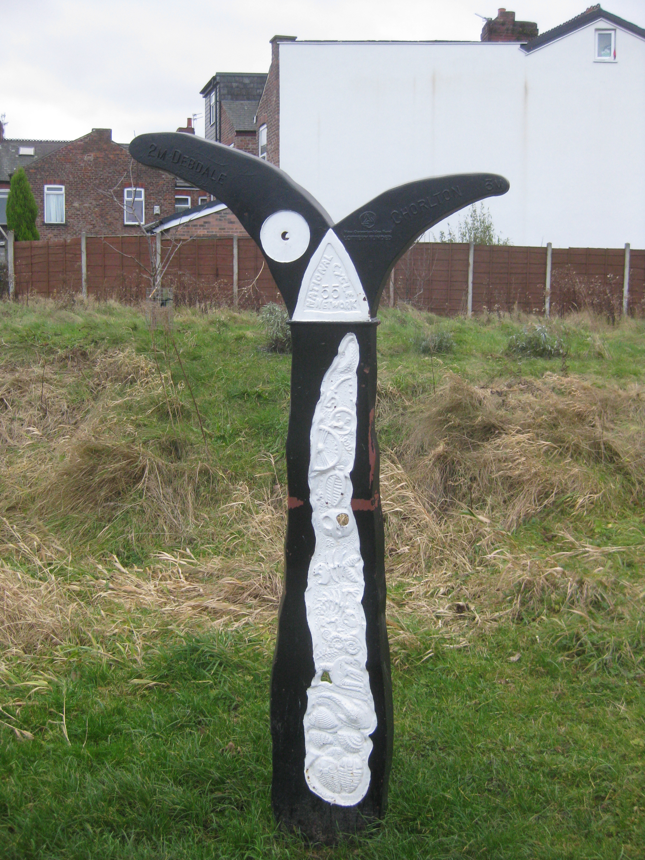
.jpg)
_-_geograph.org.uk_-_1243745.jpg)
_Gartness_Loch_Lomond_20190907_0120.jpg)
_Glen_Ogle.jpg)
_Kingussie_Railway_Station_20190920_0126.jpg)
_Markinch_20190825_0119.jpg)
_Musselburgh.jpg)
.jpg)
_Pillar_of_Hercules_Cafe_20190825_0112.jpg)
_Livingston_20191030_0143.jpg)